more stats
3.8 miles
Distance
678 ft
Climb
-1,748 ft
Descent
01:24:03
Avg time
-1,070 ft
Altitude change
4,351 ft
Altitude min
5,512 ft
Altitude max
5,421 ft
Altitude start
4,350 ft
Altitude end
-5.3%
Grade
-55.5%
Grade max
41.3%
Grade min
1 mile
Distance climb
2 miles
Distance down
1,591 ft
Distance flat
01:24:03
Avg time

Razors Edge Details

  • Activities
    • Mountain Bike
    • Hike
    • Trail Running
  • Riding Area
  • Difficulty Rating
  • Voted Difficulty
    Black Diamond (8 votes)
  • Local Popularity
    70 in Mountain Biking [+]
    • 50 in Trail Running
    • 75 in Hiking
  • Global Ranking
    #839 in Mountain Biking [+]
    • #64078 in Trail Running
    • #1724 in Hiking
  • Trail Type
    Singletrack
  • Bike Type
    AM
  • Direction
    Downhill Primary
    Popular Direction Shown
  • Climb Difficulty
    Black Diamond
  • Physical Rating
    Hard
  • Dogs Allowed
    Yes
  • TTFs on Trail
    Rock Face

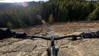
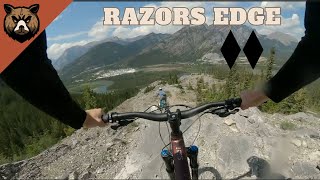
An incredible trail with stellar views and exciting terrain that puts it in a class of its own. Razors Edge is like no other ride in the Bow Valley. It’s a BIG all mountain trail that utilizes the distinct and rugged terrain found in Quaite Valley. Accessible via Quaite Valley and Prairie View, Razors starts innocently enough. The first section of undulating singletrack running along a bench cut is one of the easier sections to navigate on this ride. Ascending gradually out of the thick forest and up to the first of many ridge lines, the trail only gets more intense. On the way up you’ll be greeted with short, but steep sections of slab; while climbing and descending. Once on the ridge, the riding gets very technical. The narrow sections of ridge made up of rock, boulders and slab will keep one on their toes, while the descents down the longer sections of slab foretell of the riding yet to come.

What makes this ride so unique is the final section of exposed, steep and open ridge. Expect long and steep sections of slab and in some cases very loose rocks. Incredible views of the surrounding mountains and valley below make this ride not only scenic, but spectacular. The trail builder has really nailed it with this trail, offering something for the more advanced rider that currently does not compare to any other rides in the Bow Valley.

Read more: http://www.bikepirate.com/all-mtn-trails/razors-edge/#ixzz3FfyuPInn

Recent Activity on Trail

Past Week
  • 9 rides
  • 12 miles average
6 Months
  • 13 rides
  • 11 miles avg distance
All
  • 341 rides
  • Last: Jun 19, 2026
c1c2c3c4
January
February
March
April
May
June
July
August
September
October
November
December
update trails status or condition

Razors Edge Trail Reports

statusdatedescription
Aug 2, 2025 @ 4:14pm
Aug 2, 2025
It's in great shape. No issues.
Nov 9, 2024 @ 9:00am
Nov 9, 2024
Riding amazing. Quate access is muddy
Oct 5, 2024 @ 2:58pm
Oct 5, 2024
Sep 21, 2024 @ 3:08pm
Sep 21, 2024
Roots are a little slick in the trees on the traverse over to the summit also rocks near the top are a little damp but easy to find good lines.
Aug 1, 2024 @ 5:43pm
Aug 1, 2024
Very dry and loose.
more »
Status:
on Aug 2, 2025
Ideal
Avg: 4.47 (73 votes)
Your vote: 0

view (2,950)
close
3D
Trail Conditions
  • Unknown
  • Snow Groomed
  • Snow Packed
  • Snow Covered
  • Snow Cover Partial
  • Freeze/thaw Cycle
  • Icy
  • Prevalent Mud
  • Wet
  • Variable
  • Ideal
  • Dry
  • Very Dry
Trail Flow (Ridden Direction)
Trailforks scans users ridelogs to determine the most popular direction each trail is ridden. A good flowing trail network will have most trails flowing in a single direction according to their intension.
The colour categories are based on what percentage of riders are riding a trail in its intended direction.
  • > 96%
  • > 90%
  • > 80%
  • > 70%
  • > 50%
  • < 50%
  • bi-directional trail
  • no data
Trail Last Ridden
Trailforks scans ridelogs to determine the last time a trail was ridden.
  • < 2 days
  • < 1 week
  • < 2 weeks
  • < 1 month
  • < 6 months
  • > 6 months
Trail Ridden Direction
The intended direction a trail should be ridden.
  • Downhill Only
  • Downhill Primary
  • Both Directions
  • Uphill Primary
  • Uphill Only
  • One Direction
Contribute Details
Colors indicate trail is missing specified detail.
  • Description
  • Photos
  • Description & Photos
  • Videos
Trail Popularity ?
Trailforks scans ridelogs to determine which trails are ridden the most in the last 9 months. Trails are compared with nearby trails in the same city region with a possible 25 colour shades. Think of this as a heatmap, more rides = more kinetic energy = warmer colors.
  • most popular
  • popular
  • less popular
  • not popular
ATV/ORV/OHV Filter
Max Vehicle Width
inches
US Cell Coverage
Legend
cell carrier legend

Radar Time
Activity Recordings
Trailforks uses anonymized public activity data. ?
Activity Recordings
Trailforks uses anonymized public activity data. ?
Personal Heatmap
Activity Types
all / none
Options
2
Date range month
Winter Trails
Warning A routing network for winter maps does not exist. Selecting trails using the winter trails layer has been disabled.
Missing Trails
Most Popular
Least Popular
Trails are colored based on popularity. The more popular a trail is, the more red. Less popular trails trend towards green.
Jump Magnitude Heatmap
Heatmap of where riders jump on trails. Zoom in to see individual jumps, click circles to view jump details.
BC Backroad Status

Service Road Atlas is a free to use, community-driven service for viewing and creating reports on the numerous back-country service roads around B.C. and Alberta.

map legend
Slope Aspect
Direction the slope faces
Flat N NE E SE S SW W NW
Trails Deemphasized
Trails are shown in grey.
disable
Only show trails with no bike usage.
Enable
Suggested Layers
Based on selected activity type

    Save the current map location and zoom level as your default home location whenever this page is loaded.

    Save
        Directions to razors-edge trailhead (51.042680, -115.090160)

        Photos

        153 more »
        3,084 |
        Sep 23, 2014 @ 10:30am
        Sep 23, 2014
        3,646 |
        Aug 16, 2014 @ 10:12pm
        Aug 16, 2014
        19 |
        Jun 13, 2026 @ 6:46am
        Jun 13, 2026
        97 |
        Oct 12, 2024 @ 7:23pm
        Oct 12, 2024

        Videos

        38 more »
        youtuber I was WARNED // Attempting The Hardest Local...
        15:56 | 3163 | Jun 17, 2020 , Canmore
        Riding the Legendary Razors Edge – Bow...
        14:26 | 91 | Nov 13, 2025 , Canmore
        Average Dude Rides The Razors Edge in Canmore
        27:31 | 174 | Jul 15, 2025 , Canmore
        youtuber How Not to Ride Razors Edge | Alberta Double...
        17:15 | 548 | Sep 7, 2024 , Canmore

        Routes with this trail

        4.0 11 miles 1,902 ft 7 Loop
        razors edge loop from parking lot
        5.0 12 miles 3,102 ft 5
        Jewell Pass Prairie View and Razors Edge
        1.0 162 miles 19,314 ft 106 Loop
        Think you've got what it takes to tackle this monster ride? This is the ultimate link-up of single track...

        12 Reviews & Comments


        We hope you've been enjoying Trailforks!

        Create a FREE account to view trail comments and much more.

        • By mtnbikermitchTF Pro & contributors
        • #16638 - 55,778 views

        Frequently Asked Questions About Razors Edge

        Where is Razors Edge located?
        Razors Edge is located in Bow Valley Wildland Provincial Park, Canmore, Alberta, Canada. It is part of the Bow Valley Wildland Provincial Park trail network. The trailhead is located at coordinates 51.04268, -115.09016.
        How hard is Razors Edge?
        Razors Edge is rated as Double Black Diamond difficulty. The physical rating is Hard. The average grade is 5.3%. The climb difficulty is rated Black Diamond.
        What is the elevation gain for Razors Edge?
        Razors Edge has 207 m of elevation gain. The trail has 533 m of elevation descent. The elevation ranges from 1,326 m to 1,680 m.
        Is Razors Edge a point to point trail?
        Razors Edge is not a point to point trail. The direction is Downhill Primary. The trail type is singletrack.

        Hit the Trail

        Open in App

        Get this trail on your phone instantly.
        open trail in app

        Download Trail

        Save to wishlist, Garmin & download.
        save the trail

        Find Related Routes

        Find routes and users activities that include this trail.
        find routes for this trail

        You must enter a description before submitting.