more stats
899 ft
Distance
96 ft
Climb
-8 ft
Descent
00:05:26
Avg time
92 ft
Altitude change
184 ft
Altitude min
276 ft
Altitude max
184 ft
Altitude start
276 ft
Altitude end
10.2%
Grade
-3.6%
Grade max
45.7%
Grade min
548 ft
Distance climb
184 ft
Distance down
135 ft
Distance flat
00:05:26
Avg time

Red Belly Details

  • Activities
    • Mountain Bike
    • E-Bike
  • Riding Area
    Smithfield
    Cairns
  • Difficulty Rating
  • Local Popularity
    100 in Mountain Biking [+]
    • 100 in E-Biking
  • Global Ranking
    #21591 in Mountain Biking [+]
    • #3147 in E-Biking
  • Trail Type
    Singletrack
  • Bike Type
    AM, XC
  • Direction
    One Direction
    Popular Direction Shown
  • Climb Difficulty
    Blue
  • Physical Rating
    Moderate
  • eBike Allowed
    Yes up to Class 1
  • TTFs on Trail
    Berm, Jump

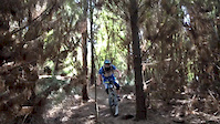
One of Smithfields newer trails, has a very smooth flowy climb with multiple switchbacks that leads into a fast flowy decent with long berms and a medium sized rock jump near the end of the trail.

Access Info

Trail starts after the trail merge of Flat Snake and Black Snake, then through several fast berms. Red Belly is the trail to the right or you can continue along Flat Snake to the left. Both trails link back to the McGregor Road trailhead carpark

Disclaimer

This trail becomes very slippery in the wet, ride cautiously.

Local Trail Association
Traditionally Indigenous Territory

Recent Activity on Trail

Past Week
  • 3 rides
  • 4 miles average
6 Months
  • 45 rides
  • 6 miles avg distance
All
  • 886 rides
  • Last: Jun 14, 2026
c1c2c3c4
January
February
March
April
May
June
July
August
September
October
November
December
update trails status or condition

Red Belly Trail Reports

statusdatedescription
May 17, 2026 @ 7:26am (Australia/Brisbane)
May 16, 2026
reporter
Mar 5, 2026 @ 1:03pm (America/Los_Angeles)
Mar 5, 2026
reporter Closed for weather event - muddy conditions Trails will need to be inspected before reopening
Jan 16, 2026 @ 9:28am (Australia/Brisbane)
Jan 15, 2026
Tree down RB climb
Dec 31, 2025 @ 4:48pm (Australia/Brisbane)
Dec 30, 2025
reporter Trees down climb
Dec 31, 2025 @ 8:50am (Australia/Brisbane)
Dec 30, 2025
reporter
more »
Status:
on May 17, 2026
Wet
Avg: 4.19 (4 votes)
Your vote: 0

view (8,059)
close
3D
Trail Conditions
  • Unknown
  • Snow Groomed
  • Snow Packed
  • Snow Covered
  • Snow Cover Partial
  • Freeze/thaw Cycle
  • Icy
  • Prevalent Mud
  • Wet
  • Variable
  • Ideal
  • Dry
  • Very Dry
Trail Flow (Ridden Direction)
Trailforks scans users ridelogs to determine the most popular direction each trail is ridden. A good flowing trail network will have most trails flowing in a single direction according to their intension.
The colour categories are based on what percentage of riders are riding a trail in its intended direction.
  • > 96%
  • > 90%
  • > 80%
  • > 70%
  • > 50%
  • < 50%
  • bi-directional trail
  • no data
Trail Last Ridden
Trailforks scans ridelogs to determine the last time a trail was ridden.
  • < 2 days
  • < 1 week
  • < 2 weeks
  • < 1 month
  • < 6 months
  • > 6 months
Trail Ridden Direction
The intended direction a trail should be ridden.
  • Downhill Only
  • Downhill Primary
  • Both Directions
  • Uphill Primary
  • Uphill Only
  • One Direction
Contribute Details
Colors indicate trail is missing specified detail.
  • Description
  • Photos
  • Description & Photos
  • Videos
Trail Popularity ?
Trailforks scans ridelogs to determine which trails are ridden the most in the last 9 months. Trails are compared with nearby trails in the same city region with a possible 25 colour shades. Think of this as a heatmap, more rides = more kinetic energy = warmer colors.
  • most popular
  • popular
  • less popular
  • not popular
ATV/ORV/OHV Filter
Max Vehicle Width
inches
US Cell Coverage
Legend
cell carrier legend

Radar Time
Activity Recordings
Trailforks uses anonymized public activity data. ?
Activity Recordings
Trailforks uses anonymized public activity data. ?
Personal Heatmap
Activity Types
all / none
Options
2
Date range month
Winter Trails
Warning A routing network for winter maps does not exist. Selecting trails using the winter trails layer has been disabled.
Missing Trails
Most Popular
Least Popular
Trails are colored based on popularity. The more popular a trail is, the more red. Less popular trails trend towards green.
Jump Magnitude Heatmap
Heatmap of where riders jump on trails. Zoom in to see individual jumps, click circles to view jump details.
BC Backroad Status

Service Road Atlas is a free to use, community-driven service for viewing and creating reports on the numerous back-country service roads around B.C. and Alberta.

map legend
Slope Aspect
Direction the slope faces
Flat N NE E SE S SW W NW
Trails Deemphasized
Trails are shown in grey.
disable
Only show trails with no bike usage.
Enable
Suggested Layers
Based on selected activity type

    Save the current map location and zoom level as your default home location whenever this page is loaded.

    Save
        Directions to red-belly trailhead (-16.818230, 145.681270)

        Photos

        0 more »
        38 |
        Jan 15, 2026 @ 3:30pm
        Jan 15, 2026
        76 |
        Dec 31, 2025 @ 3:46pm
        Dec 31, 2025
        26 |
        Dec 31, 2025 @ 3:46pm
        Dec 31, 2025

        Videos

        2 more »
        David McMillan - Majura Pines
        0:28 | 5263 | Jul 11, 2010 , Cairns
        Churchill Pines - Ellis HayesHills
        0:19 | 320 | Jan 20, 2014 , Cairns

        Reviews / Comments

        No reviews yet, be the first to write a review or ask a question.
        Use trail reports to comment on trail conditions.


        We hope you've been enjoying Trailforks!

        Create a FREE account to view trail comments and much more.

        Frequently Asked Questions About Red Belly

        Where is Red Belly located?
        Red Belly is located in Smithfield, Cairns, Australia. It is part of the Smithfield trail network. The trailhead is located at coordinates -16.81823, 145.68127.
        How hard is Red Belly?
        Red Belly is rated as Blue difficulty. The physical rating is Moderate. The average grade is 10.2%. The climb difficulty is rated Blue.
        What is the elevation gain for Red Belly?
        Red Belly has 96 ft of elevation gain. The trail has 8 ft of elevation descent. The elevation ranges from 184 ft to 276 ft.
        Is Red Belly a point to point trail?
        Yes, Red Belly is a point to point trail. The direction is One Direction. The trail type is singletrack.

        Hit the Trail

        Open in App

        Get this trail on your phone instantly.
        open trail in app

        Download Trail

        Save to wishlist, Garmin & download.
        save the trail

        Find Related Routes

        Find routes and users activities that include this trail.
        find routes for this trail

        You must enter a description before submitting.