more stats
1.1 miles
Distance
18 ft
Climb
-1,009 ft
Descent
00:08:00
Avg time
-990 ft
Altitude change
7,133 ft
Altitude min
8,137 ft
Altitude max
8,123 ft
Altitude start
7,133 ft
Altitude end
-16.6%
Grade
-56%
Grade max
6.5%
Grade min
440 ft
Distance climb
5,272 ft
Distance down
236 ft
Distance flat
00:08:00
Avg time

Red Bull Details

  • Activities
    • Mountain Bike
  • Riding Area
    Park City Mountain Resort
    Park City, Utah
  • AKA
    Ski Team Trail, Ski School
  • Difficulty Rating
  • Voted Difficulty
    Black Diamond (15 votes)
  • Local Popularity
    65 in Mountain Biking
  • Global Ranking
    #22360 in Mountain Biking
  • Trail Type
    Singletrack
  • Bike Type
    DH, AM, XC
  • Physical Rating
    Moderate
  • Trail Visibility
    Sometimes hard to follow
  • Season
    April-October
  • Dogs Allowed
    Yes
  • eBike Allowed
  • TTFs on Trail
    Drop, Jump
  • Ride in Rain
    Yes
  • Year Opened
    2008

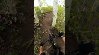
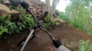
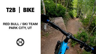
Red Bull (AKA Ski School or Ski Team) is an unmarked trail but has been around longer than most of the others on the mountain. Its one of the steeper and more tech descents littered with a good variety of fast and narrow singletrack, rocky/rutted loose sections and rooty fun all sprinkled with pretty steep sections. CAUTION: THERE ARE TRAIL CROSSINGS. DO NOT BLINDLY RIP DOWN THIS TRAIL.

Access Info

Ride to where Jenny's meets Mid Mountain trail at the top of the Pay Day lift. Riders left of the lift you'll see where they store the rails/boxes for the season. Go past those features and eventually you'll see a packed in path leading left into the woods on the spine of one of the big gravel water bars.

This trail is unsanctioned.

Traditionally Indigenous Territory

Recent Activity on Trail

Past Week
  • 6 rides
  • 14 miles average
6 Months
  • 22 rides
  • 13 miles avg distance
All
  • 314 rides
  • Last: Jun 20, 2026
c1c2c3c4
January
February
March
April
May
June
July
August
September
October
November
December
update trails status or condition

Red Bull Trail Reports

statusdatedescription
Jun 20, 2026 @ 10:46pm (America/Denver)
2 hours
Needs a haircut.
Jun 18, 2026 @ 5:45pm (America/Denver)
2 days
dusty but it goes
Nov 14, 2025 @ 2:52pm (America/Denver)
Nov 14, 2025
1st corner after upper Jennis jct: Large tree down across trail, blocking trail
Nov 2, 2025 @ 8:36am (America/Denver)
Nov 2, 2025
Muddy and slippy after 10am. Tree down just below highest Jenni's crossing.
Oct 26, 2025 @ 8:59am (America/Denver)
Oct 26, 2025
Best I've seen it in 2025
more »
Status:
on Jun 20, 2026
Dry
Avg: 4.51 (30 votes)
Your vote: 0

view (2,680)
close
3D
Trail Conditions
  • Unknown
  • Snow Groomed
  • Snow Packed
  • Snow Covered
  • Snow Cover Partial
  • Freeze/thaw Cycle
  • Icy
  • Prevalent Mud
  • Wet
  • Variable
  • Ideal
  • Dry
  • Very Dry
Trail Flow (Ridden Direction)
Trailforks scans users ridelogs to determine the most popular direction each trail is ridden. A good flowing trail network will have most trails flowing in a single direction according to their intension.
The colour categories are based on what percentage of riders are riding a trail in its intended direction.
  • > 96%
  • > 90%
  • > 80%
  • > 70%
  • > 50%
  • < 50%
  • bi-directional trail
  • no data
Trail Last Ridden
Trailforks scans ridelogs to determine the last time a trail was ridden.
  • < 2 days
  • < 1 week
  • < 2 weeks
  • < 1 month
  • < 6 months
  • > 6 months
Trail Ridden Direction
The intended direction a trail should be ridden.
  • Downhill Only
  • Downhill Primary
  • Both Directions
  • Uphill Primary
  • Uphill Only
  • One Direction
Contribute Details
Colors indicate trail is missing specified detail.
  • Description
  • Photos
  • Description & Photos
  • Videos
Trail Popularity ?
Trailforks scans ridelogs to determine which trails are ridden the most in the last 9 months. Trails are compared with nearby trails in the same city region with a possible 25 colour shades. Think of this as a heatmap, more rides = more kinetic energy = warmer colors.
  • most popular
  • popular
  • less popular
  • not popular
ATV/ORV/OHV Filter
Max Vehicle Width
inches
US Cell Coverage
Legend
cell carrier legend

Radar Time
Activity Recordings
Trailforks uses anonymized public activity data. ?
Activity Recordings
Trailforks uses anonymized public activity data. ?
Personal Heatmap
Activity Types
all / none
Options
2
Date range month
Winter Trails
Warning A routing network for winter maps does not exist. Selecting trails using the winter trails layer has been disabled.
Missing Trails
Most Popular
Least Popular
Trails are colored based on popularity. The more popular a trail is, the more red. Less popular trails trend towards green.
Jump Magnitude Heatmap
Heatmap of where riders jump on trails. Zoom in to see individual jumps, click circles to view jump details.
BC Backroad Status

Service Road Atlas is a free to use, community-driven service for viewing and creating reports on the numerous back-country service roads around B.C. and Alberta.

map legend
Slope Aspect
Direction the slope faces
Flat N NE E SE S SW W NW
Trails Deemphasized
Trails are shown in grey.
disable
Only show trails with no bike usage.
Enable
Suggested Layers
Based on selected activity type

    Save the current map location and zoom level as your default home location whenever this page is loaded.

    Save
        Directions to red-bull trailhead (40.632800, -111.512610)

        Photos

        10 more »
        131 |
        Aug 11, 2023 @ 2:05pm
        Aug 11, 2023
        149 |
        Jun 16, 2023 @ 6:51am
        Jun 16, 2023
        211 |
        Oct 24, 2022 @ 12:30am
        Oct 24, 2022
        185 |
        Oct 24, 2022 @ 12:29am
        Oct 24, 2022

        Videos

        17 more »
        Red Bull - Park City, UT - MTB Trail...
        0:39 | 278 | Jul 7, 2025 , Park City
        Silverqueen // Redbull // Crescent Mine Grade...
        16:05 | 639 | Aug 21, 2022 , Park City
        First Time On A Double Black, Its $@%# Scary |...
        7:01 | 997 | Jul 30, 2021 , Park City
        Red Bull / Ski Team – Park City, UT  |  T2B...
        4:29 | 774 | Jun 29, 2021 , Park City

        Routes with this trail

        4.0 5 miles 998 ft 17
        A good climb to an awesome descent. Easy loop to do in a couple of hours.
        5 miles 38 ft 11 Point to Point
        This is a series of blue trails.
        44 miles 8,121 ft 64
        complete all day all mountain ride

        26 Reviews & Comments


        We hope you've been enjoying Trailforks!

        Create a FREE account to view trail comments and much more.

        • #31145 - 15,983 views

        Frequently Asked Questions About Red Bull

        Where is Red Bull located?
        Red Bull is located in Park City Mountain Resort, Park City, Utah, United States. It is part of the Park City Mountain Resort trail network. The trailhead is located at coordinates 40.6328, -111.51261.
        How hard is Red Bull?
        Red Bull is rated as Double Black Diamond difficulty. The physical rating is Moderate. The average grade is 16.6%.
        What is the elevation gain for Red Bull?
        Red Bull has 6 m of elevation gain. The trail has 307 m of elevation descent. The elevation ranges from 2,174 m to 2,480 m.
        How long is Red Bull?
        Red Bull is 1.8 km long. The trail type is singletrack.

        Hit the Trail

        Open in App

        Get this trail on your phone instantly.
        open trail in app

        Download Trail

        Save to wishlist, Garmin & download.
        save the trail

        Find Related Routes

        Find routes and users activities that include this trail.
        find routes for this trail

        You must enter a description before submitting.