more stats
1.5 miles
Distance
15 ft
Climb
-750 ft
Descent
00:15:57
Avg time
-736 ft
Altitude change
1,868 ft
Altitude min
2,615 ft
Altitude max
2,604 ft
Altitude start
1,870 ft
Altitude end
-9.5%
Grade
-38.4%
Grade max
9%
Grade min
541 ft
Distance climb
1 mile
Distance down
502 ft
Distance flat
00:15:57
Avg time

Red Mountain Rush Details

  • Activities
    • Mountain Bike
    • Hike
    • Trail Running
  • Riding Area
    Hawes
    Mesa, Arizona
  • AKA
    Red Mtn Rush, RMR
  • Difficulty Rating
  • Voted Difficulty
    Blue (25 votes)
  • Local Popularity
    95 in Mountain Biking [+]
    • 70 in Trail Running
    • 65 in Hiking
  • Global Ranking
    #3250 in Mountain Biking [+]
    • #273 in Trail Running
    • #1368 in Hiking
  • Hiking SAC Scale
    T1 Hiking
  • Trail Exposure
    Normal
  • Trail Type
    Singletrack
  • Bike Type
    XC
  • Direction
    Downhill Primary
    Popular Direction Shown
  • Climb Difficulty
    Black Diamond
  • Physical Rating
    Hard
  • Trail Visibility
    Always easy to follow
  • Dogs Allowed
    Yes
  • eBike Allowed
  • Year Opened
    2021
  • Land Owner
    Tonto National Forest

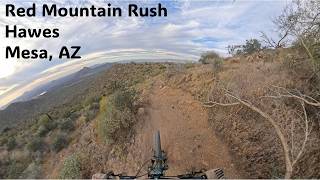
Primarily a downhill trail with a fair amount of flow. Some small rock features up top. This trail is a solid double-blue, but Trailforks doesn't have that rating capability, so it is rated higher in difficulty on the map to help prevent lesser skilled riders from getting in over their head.

Local Trail Association
Traditionally Indigenous Territory

Recent Activity on Trail

Past Week
  • 14 rides
  • 12 miles average
6 Months
  • 676 rides
  • 14 miles avg distance
All
  • 4,153 rides
  • Last: Jun 25, 2026
c1c2c3c4
January
February
March
April
May
June
July
August
September
October
November
December
update trails status or condition

Red Mountain Rush Trail Reports

statusdatedescription
May 5, 2026 @ 3:05pm (America/Phoenix)
May 5, 2026
Very dry and loose at the top sections, be very carful conditions are getting worse with every ride. Other than that the trail is running good.
Apr 22, 2026 @ 6:42pm (America/Phoenix)
Apr 22, 2026
reporter
Tread maintenance.
Mar 14, 2026 @ 4:11pm (America/Phoenix)
Mar 14, 2026
Designate as one way downhill. Very fast ride that has blind corners. Locals know but visitors don’t. Safety is the reason
Feb 15, 2026 @ 12:04pm (Pacific/Midway)
Feb 15, 2026
Feb 12, 2026 @ 3:49pm (America/Phoenix)
Feb 12, 2026
Very dry and loose at the top, ride with caution. Other than that bottom half is really good
more »
Status:
on May 5, 2026
Very Dry
Avg: 4.6 (71 votes)
Your vote: 0

view (23,831)
close
3D
Trail Conditions
  • Unknown
  • Snow Groomed
  • Snow Packed
  • Snow Covered
  • Snow Cover Partial
  • Freeze/thaw Cycle
  • Icy
  • Prevalent Mud
  • Wet
  • Variable
  • Ideal
  • Dry
  • Very Dry
Trail Flow (Ridden Direction)
Trailforks scans users ridelogs to determine the most popular direction each trail is ridden. A good flowing trail network will have most trails flowing in a single direction according to their intension.
The colour categories are based on what percentage of riders are riding a trail in its intended direction.
  • > 96%
  • > 90%
  • > 80%
  • > 70%
  • > 50%
  • < 50%
  • bi-directional trail
  • no data
Trail Last Ridden
Trailforks scans ridelogs to determine the last time a trail was ridden.
  • < 2 days
  • < 1 week
  • < 2 weeks
  • < 1 month
  • < 6 months
  • > 6 months
Trail Ridden Direction
The intended direction a trail should be ridden.
  • Downhill Only
  • Downhill Primary
  • Both Directions
  • Uphill Primary
  • Uphill Only
  • One Direction
Contribute Details
Colors indicate trail is missing specified detail.
  • Description
  • Photos
  • Description & Photos
  • Videos
Trail Popularity ?
Trailforks scans ridelogs to determine which trails are ridden the most in the last 9 months. Trails are compared with nearby trails in the same city region with a possible 25 colour shades. Think of this as a heatmap, more rides = more kinetic energy = warmer colors.
  • most popular
  • popular
  • less popular
  • not popular
ATV/ORV/OHV Filter
Max Vehicle Width
inches
US Cell Coverage
Legend
cell carrier legend

Radar Time
Activity Recordings
Trailforks uses anonymized public activity data. ?
Activity Recordings
Trailforks uses anonymized public activity data. ?
Personal Heatmap
Activity Types
all / none
Options
2
Date range month
Winter Trails
Warning A routing network for winter maps does not exist. Selecting trails using the winter trails layer has been disabled.
Missing Trails
Most Popular
Least Popular
Trails are colored based on popularity. The more popular a trail is, the more red. Less popular trails trend towards green.
Jump Magnitude Heatmap
Heatmap of where riders jump on trails. Zoom in to see individual jumps, click circles to view jump details.
BC Backroad Status

Service Road Atlas is a free to use, community-driven service for viewing and creating reports on the numerous back-country service roads around B.C. and Alberta.

map legend
Slope Aspect
Direction the slope faces
Flat N NE E SE S SW W NW
Trails Deemphasized
Trails are shown in grey.
disable
Only show trails with no bike usage.
Enable
Suggested Layers
Based on selected activity type

    Save the current map location and zoom level as your default home location whenever this page is loaded.

    Save
        Directions to red-mountain-rush trailhead (33.505120, -111.644060)

        Photos

        40 more »
        683 |
        Apr 3, 2021 @ 4:23pm
        Apr 3, 2021
        616 |
        Apr 3, 2021 @ 9:49am
        Apr 3, 2021
        59 |
        Dec 26, 2025 @ 1:34pm
        Dec 26, 2025
        71 |
        Dec 9, 2025 @ 3:52pm
        Dec 9, 2025

        Videos

        28 more »
        youtuber First ride on my 'NEW' Bike! - RIDING IN AMERICA!
        15:03 | 570 | Apr 27, 2023 , Mesa
        youtuber FLOW at it's Finest with views just as GOOD! -...
        12:41 | 1116 | Apr 20, 2022 , Mesa
        One of Arizona's Best Mountain Bike Descents |...
        7:54 | 57 | Mar 7, 2026 , Mesa
        Red Mountain Rush
        12:25 | 95 | Jan 25, 2026 , Mesa

        Routes with this trail

        4.4 14 miles 2,082 ft 9 Loop
        Three fast and flowy downhills, a sprinkling of tech, optional jumps, and huge banked turns. This...
        5.0 15 miles 2,358 ft 8 Loop
        This is a good loop that allows you to hit 3 of the best DH runs at Hawes ( , Rush, and ). Starts and ends...
        4.0 18 miles 2,803 ft 13
        Hawes Introduction Mountain Biking

        45 Reviews & Comments


        We hope you've been enjoying Trailforks!

        Create a FREE account to view trail comments and much more.

        Nearby Trails

        • By schillingsworthTF Pro TRAILFORKS HTA & contributors
        • #240754 - 14,357 views

        Frequently Asked Questions About Red Mountain Rush

        Where is Red Mountain Rush located?
        Red Mountain Rush is located in Hawes, Mesa, Arizona, United States. It is part of the Hawes trail network. The trailhead is located at coordinates 33.50512, -111.64406.
        How hard is Red Mountain Rush?
        Red Mountain Rush is rated as Black Diamond difficulty. The physical rating is Hard. The average grade is 9.5%. The climb difficulty is rated Black Diamond.
        What is the elevation gain for Red Mountain Rush?
        Red Mountain Rush has 15 ft of elevation gain. The trail has 750 ft of elevation descent. The elevation ranges from 1,868 ft to 2,615 ft.
        Is Red Mountain Rush a point to point trail?
        Red Mountain Rush is not a point to point trail. The direction is Downhill Primary. The trail type is singletrack.

        Hit the Trail

        Open in App

        Get this trail on your phone instantly.
        open trail in app

        Download Trail

        Save to wishlist, Garmin & download.
        save the trail

        Find Related Routes

        Find routes and users activities that include this trail.
        find routes for this trail

        You must enter a description before submitting.