more stats
1.8 miles
Distance
-436 ft
Descent
00:30:17
Avg time
-436 ft
Altitude change
3,946 ft
Altitude min
4,382 ft
Altitude max
4,382 ft
Altitude start
3,947 ft
Altitude end
-4.5%
Grade
-17.8%
Grade max
0.3%
Grade min
2 miles
Distance down
443 ft
Distance flat
00:30:17
Avg time

Red Run Trail Details

  • Activities
    • Mountain Bike
    • Hike
    • Trail Running
  • Riding Area
    Tea Creek Area
    Marlinton, West Virginia
  • Ref Number
    #439
  • Difficulty Rating
  • Local Popularity
    75 in Mountain Biking [+]
    • 5 in Trail Running
    • 90 in Hiking
  • Global Ranking
    #101089 in Mountain Biking [+]
    • #315703 in Trail Running
    • #325953 in Hiking
  • Hiking SAC Scale
    T2 Mountain Hiking
  • Trail Type
    Singletrack
  • Bike Type
    AM, XC
  • Direction
    Both Directions
    Popular Direction Shown
  • Physical Rating
    Hard
  • Dogs Allowed
    Yes
  • eBike Allowed
  • TTFs on Trail
    Rock Garden
  • Land Owner

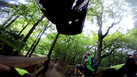
This advanced singletrack trail features raw, technical Slatyfork Spruce terrain with timeless rock gardens, log bridges, and root obstacles. One of the most rugged rides in the Mon, it descends 450 feet to the Right Fork Tea Creek Trail. Right out of the gate, users encounter a challenging root and rock garden that’s a scenic walk but a tough maneuver on a bike. The first section is flat, with a slope that gradually increases. However, riders have their work cut out to maintain speed through the twists, turns, and physical rock gardens. This loop is a Tea Creek Area favorite amongst advanced riders.

Access Info

Gauley Mountain Trail, Right Fork Tea Creek Trail

Trail Supporters

  • USFS
    Land Manager
Local Trail Association
Traditionally Indigenous Territory

Recent Activity on Trail

Past Week
  • 0 rides
  •  
6 Months
  • 0 rides
  •  
All
  • 3 rides
  • Last: Oct 5, 2025
c1c2c3c4
January
February
March
April
May
June
July
August
September
October
November
December
update trails status or condition

Red Run Trail Trail Reports

statusdatedescription
Oct 5, 2025 @ 7:48pm (America/New_York)
Oct 5, 2025
1 Tree bundle down midway through the trail. Need a brush run
Mar 3, 2024 @ 4:16am
Mar 3, 2024
Many small downed trees and limbs removed to clear the trail. A few areas were scoured from heavy rainfall but ready for action.
more »
Status:
on Oct 5, 2025
Dry
Avg: 3.86 (2 votes)
Your vote: 0

view (37)
close
3D
Trail Conditions
  • Unknown
  • Snow Groomed
  • Snow Packed
  • Snow Covered
  • Snow Cover Partial
  • Freeze/thaw Cycle
  • Icy
  • Prevalent Mud
  • Wet
  • Variable
  • Ideal
  • Dry
  • Very Dry
Trail Flow (Ridden Direction)
Trailforks scans users ridelogs to determine the most popular direction each trail is ridden. A good flowing trail network will have most trails flowing in a single direction according to their intension.
The colour categories are based on what percentage of riders are riding a trail in its intended direction.
  • > 96%
  • > 90%
  • > 80%
  • > 70%
  • > 50%
  • < 50%
  • bi-directional trail
  • no data
Trail Last Ridden
Trailforks scans ridelogs to determine the last time a trail was ridden.
  • < 2 days
  • < 1 week
  • < 2 weeks
  • < 1 month
  • < 6 months
  • > 6 months
Trail Ridden Direction
The intended direction a trail should be ridden.
  • Downhill Only
  • Downhill Primary
  • Both Directions
  • Uphill Primary
  • Uphill Only
  • One Direction
Contribute Details
Colors indicate trail is missing specified detail.
  • Description
  • Photos
  • Description & Photos
  • Videos
Trail Popularity ?
Trailforks scans ridelogs to determine which trails are ridden the most in the last 9 months. Trails are compared with nearby trails in the same city region with a possible 25 colour shades. Think of this as a heatmap, more rides = more kinetic energy = warmer colors.
  • most popular
  • popular
  • less popular
  • not popular
ATV/ORV/OHV Filter
Max Vehicle Width
inches
US Cell Coverage
Legend
cell carrier legend

Radar Time
Activity Recordings
Trailforks uses anonymized public activity data. ?
Activity Recordings
Trailforks uses anonymized public activity data. ?
Personal Heatmap
Activity Types
all / none
Options
2
Date range month
Winter Trails
Warning A routing network for winter maps does not exist. Selecting trails using the winter trails layer has been disabled.
Missing Trails
Most Popular
Least Popular
Trails are colored based on popularity. The more popular a trail is, the more red. Less popular trails trend towards green.
Jump Magnitude Heatmap
Heatmap of where riders jump on trails. Zoom in to see individual jumps, click circles to view jump details.
BC Backroad Status

Service Road Atlas is a free to use, community-driven service for viewing and creating reports on the numerous back-country service roads around B.C. and Alberta.

map legend
Slope Aspect
Direction the slope faces
Flat N NE E SE S SW W NW
Trails Deemphasized
Trails are shown in grey.
disable
Only show trails with no bike usage.
Enable
Suggested Layers
Based on selected activity type

    Save the current map location and zoom level as your default home location whenever this page is loaded.

    Save
        Directions to red-run-trail trailhead (38.362430, -80.152670)

        Photos

        0 more »
        53 |
        Oct 5, 2025 @ 4:48pm
        Oct 5, 2025

        Videos

        1 more »
        Aston Hill - Red Run
        2:12 | 822 | Sep 23, 2014 , Marlinton

        Routes with this trail

        5.0 21 miles 2,946 ft 5 Loop
        Starting at Campground, ascend to the top Trailhead (FR 135), then follow for about a mile to reach , one...
        15 miles 1,505 ft 7
        This ride incorporates two of the larger advanced loops in the Tea Creek System, offering riders two...
        43 miles 5,338 ft 18
        This route, designated an IMBA EPIC, is a challenging backcountry ride on the Monongahela National Forest...

        Reviews / Comments

        No reviews yet, be the first to write a review or ask a question.
        Use trail reports to comment on trail conditions.


        We hope you've been enjoying Trailforks!

        Create a FREE account to view trail comments and much more.

        • By rsdobbins & contributors
        • #8431 - 1,876 views

        Frequently Asked Questions About Red Run Trail

        Where is Red Run Trail located?
        Red Run Trail is located in Tea Creek Area, Marlinton, West Virginia, United States. It is part of the Tea Creek Area trail network. The trailhead is located at coordinates 38.36243, -80.15267.
        How hard is Red Run Trail?
        Red Run Trail is rated as Black Diamond difficulty. The physical rating is Hard. The average grade is 4.5%.
        What is the elevation gain for Red Run Trail?
        The trail has 436 ft of elevation descent. The elevation ranges from 3,946 ft to 4,382 ft.
        Is Red Run Trail a point to point trail?
        Red Run Trail is not a point to point trail. The direction is Both Directions. The trail type is singletrack.

        Hit the Trail

        Open in App

        Get this trail on your phone instantly.
        open trail in app

        Download Trail

        Save to wishlist, Garmin & download.
        save the trail

        Find Related Routes

        Find routes and users activities that include this trail.
        find routes for this trail

        You must enter a description before submitting.