more stats
1.8 miles
Distance
64 ft
Climb
-534 ft
Descent
00:14:31
Avg time
-472 ft
Altitude change
565 ft
Altitude min
1,053 ft
Altitude max
1,037 ft
Altitude start
564 ft
Altitude end
-4.9%
Grade
-23.1%
Grade max
12.7%
Grade min
1,168 ft
Distance climb
1 mile
Distance down
1,253 ft
Distance flat
00:14:31
Avg time

Redback Details

  • Activities
    • Mountain Bike
    • Horse
    • Hike
    • Trail Running
  • Riding Area
    Sterling Forest State Park
    Tuxedo, New York
  • Difficulty Rating
  • Local Popularity
    80 in Mountain Biking [+]
    • 95 in Trail Running
    • 75 in Hiking
    • 5 in Horseback
  • Global Ranking
    #24768 in Mountain Biking [+]
    • #24650 in Trail Running
    • #82906 in Hiking
    • #2055 in Horseback
  • Hiking SAC Scale
    T1 Hiking
  • Trail Type
    Mixed
  • Bike Type
    AM, XC, Fat
  • Direction
    Both Directions
  • Climb Difficulty
    Blue
  • Physical Rating
    Moderate
  • Trail Visibility
    Always easy to follow
  • Season
    All but free/thaw and heavy rain
  • Dogs Allowed
    Yes
  • eBike Allowed
  • TTFs on Trail
    Rock Face, Rock Garden, Roller Coaster, Skinny, Wallride
  • Year Opened
    2015
  • Land Owner

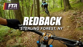
This part of Redback was rebuilt between the fall of 2015 and spring of 2017. The original trail followed a woods road for its entirety. The new sections run adjacent to the same road system, still using portions of it.

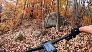
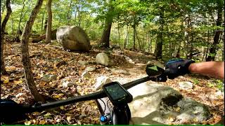
Leaving the parking lot at Souh Gate Road the first section of rebuilt trail trail quickly leaves the old road and climbs gradually for about 1/3 mile before rejoining the road. Soon after the trail passes its junction with the Munsee Eagle Trail and then leaves the road on the right. The trail continues to climb for another 1/3 mile on a new section before again rejoining the road for another short piece. The trail then leaves the road to the left and descends gradually for about 1/4 mile on single track and then again rejoins the road. Following the road the trail passes the ruins of the Redback Mine.

After passing the mine, the trail leaves the road to the left and climbs to its junction with the Hutchinson Trail. At the junction Hutchinson continues straight. The Redback 'hike-a-bike' Trail, which is not reccomended for bikes is on the left.

Trail Supporters
Local Trail Association
Traditionally Indigenous Territory

Recent Activity on Trail

Past Week
  • 15 rides
  • 10 miles average
6 Months
  • 140 rides
  • 10 miles avg distance
All
  • 1,725 rides
  • Last: Jun 17, 2026
c1c2c3c4
January
February
March
April
May
June
July
August
September
October
November
December
update trails status or condition

Redback Trail Reports

Status:
on Jun 13, 2026
Ideal
Avg: 4.62 (10 votes)
Your vote: 0

view (7,972)
close
3D
Trail Conditions
  • Unknown
  • Snow Groomed
  • Snow Packed
  • Snow Covered
  • Snow Cover Partial
  • Freeze/thaw Cycle
  • Icy
  • Prevalent Mud
  • Wet
  • Variable
  • Ideal
  • Dry
  • Very Dry
Trail Flow (Ridden Direction)
Trailforks scans users ridelogs to determine the most popular direction each trail is ridden. A good flowing trail network will have most trails flowing in a single direction according to their intension.
The colour categories are based on what percentage of riders are riding a trail in its intended direction.
  • > 96%
  • > 90%
  • > 80%
  • > 70%
  • > 50%
  • < 50%
  • bi-directional trail
  • no data
Trail Last Ridden
Trailforks scans ridelogs to determine the last time a trail was ridden.
  • < 2 days
  • < 1 week
  • < 2 weeks
  • < 1 month
  • < 6 months
  • > 6 months
Trail Ridden Direction
The intended direction a trail should be ridden.
  • Downhill Only
  • Downhill Primary
  • Both Directions
  • Uphill Primary
  • Uphill Only
  • One Direction
Contribute Details
Colors indicate trail is missing specified detail.
  • Description
  • Photos
  • Description & Photos
  • Videos
Trail Popularity ?
Trailforks scans ridelogs to determine which trails are ridden the most in the last 9 months. Trails are compared with nearby trails in the same city region with a possible 25 colour shades. Think of this as a heatmap, more rides = more kinetic energy = warmer colors.
  • most popular
  • popular
  • less popular
  • not popular
ATV/ORV/OHV Filter
Max Vehicle Width
inches
US Cell Coverage
Legend
cell carrier legend

Radar Time
Activity Recordings
Trailforks uses anonymized public activity data. ?
Activity Recordings
Trailforks uses anonymized public activity data. ?
Personal Heatmap
Activity Types
all / none
Options
2
Date range month
Winter Trails
Warning A routing network for winter maps does not exist. Selecting trails using the winter trails layer has been disabled.
Missing Trails
Most Popular
Least Popular
Trails are colored based on popularity. The more popular a trail is, the more red. Less popular trails trend towards green.
Jump Magnitude Heatmap
Heatmap of where riders jump on trails. Zoom in to see individual jumps, click circles to view jump details.
BC Backroad Status

Service Road Atlas is a free to use, community-driven service for viewing and creating reports on the numerous back-country service roads around B.C. and Alberta.

map legend
Slope Aspect
Direction the slope faces
Flat N NE E SE S SW W NW
Trails Deemphasized
Trails are shown in grey.
disable
Only show trails with no bike usage.
Enable
Suggested Layers
Based on selected activity type

    Save the current map location and zoom level as your default home location whenever this page is loaded.

    Save
        Directions to redback-67062 trailhead (41.186410, -74.241480)

        Photos

        44 more »
        39 |
        Nov 19, 2025 @ 12:41pm
        Nov 19, 2025
        43 |
        Nov 19, 2025 @ 12:40pm
        Nov 19, 2025
        86 |
        Sep 28, 2023 @ 4:27am
        Sep 28, 2023
        176 |
        Apr 2, 2022 @ 4:11pm
        Apr 2, 2022

        Videos

        4 more »
        youtuber Redback – Sterling Forest State Park, Tuxedo...
        3:23 | 295 | Nov 7, 2023 , Tuxedo
        Redback Trail - 1st Entering Park Nov 10, 2021
        3:10 | 320 | Nov 12, 2021 , Tuxedo
        Sterling Forest Mountain Biking Oct 14, 2021
        41:35 | 200 | Oct 16, 2021 , Tuxedo
        Red Back Trail - Sterling Forrest, NY -...
        1379 | Dec 17, 2016 , Tuxedo

        Routes with this trail

        8 miles 1,062 ft 10 Loop
        From South Gate, you can ride both directions.
        5.0 7 miles 942 ft 10 Loop
        Route from s parking lot, rides well in both directions.
        4.0 18 miles 1,720 ft 4 Loop
        This is the route from Shepherds Lake in Ringwood State Park, to the Munsee Eagle Trail in Sterling Forest.

        5 Reviews & Comments


        We hope you've been enjoying Trailforks!

        Create a FREE account to view trail comments and much more.

        Frequently Asked Questions About Redback

        Where is Redback located?
        Redback is located in Sterling Forest State Park, Tuxedo, New York, United States. It is part of the Sterling Forest State Park trail network. The trailhead is located at coordinates 41.18641, -74.24148.
        How hard is Redback?
        Redback is rated as Blue difficulty. The physical rating is Moderate. The average grade is 4.9%. The climb difficulty is rated Blue.
        What is the elevation gain for Redback?
        Redback has 64 ft of elevation gain. The trail has 534 ft of elevation descent. The elevation ranges from 565 ft to 1,053 ft.
        Is Redback a point to point trail?
        Redback is not a point to point trail. The direction is Both Directions. The trail type is mixed.

        Hit the Trail

        Open in App

        Get this trail on your phone instantly.
        open trail in app

        Download Trail

        Save to wishlist, Garmin & download.
        save the trail

        Find Related Routes

        Find routes and users activities that include this trail.
        find routes for this trail

        You must enter a description before submitting.