more stats
1,594 ft
Distance
-187 ft
Descent
00:01:33
Avg time
-187 ft
Altitude change
614 ft
Altitude min
801 ft
Altitude max
801 ft
Altitude start
614 ft
Altitude end
-11.7%
Grade
-30.9%
Grade max
-1.5%
Grade min
1,417 ft
Distance down
151 ft
Distance flat
00:01:33
Avg time

Relish Upper Details

  • Activities
    • Mountain Bike
    • E-Bike
  • Riding Area
  • Difficulty Rating
  • Local Popularity
    95 in Mountain Biking [+]
    • 90 in E-Biking
  • Global Ranking
    #807 in Mountain Biking [+]
    • #16111 in E-Biking
  • Trail Type
    Singletrack
  • Bike Type
    AM, XC
  • Direction
    One Direction
    Popular Direction Shown
  • Physical Rating
    Moderate
  • Trail Visibility
    Always easy to follow
  • eBike Allowed
    Yes up to Class 1
  • Year Opened
    2022
  • Land Owner
    Birse Community Trust

For a long time, The ATA has been working with landowners to look at the addition of a trail in Birse Forest. Ellie, a long standing ATA volunteer, and Aboyne's Trail Lead, has worked with Birse Community Trust - BCT to consider how best to develop the existing trail network in line with both BCT and The ATA core values.

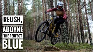
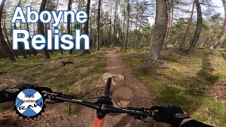
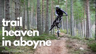
With the recent storms and subsequent damage, it's fair to say that Chutney has seen more traffic. So, it was as good a time as any to set this plan into action and give Chutney a brother... Relish!

After some planning between The ATA and the landowners, DMBinS and North East Adventure Tourism were able to support both in planning, and financially to get the project off the ground. With funding in place, the growing legends from Crc Scot were able to come in and lay down a fun, flowy, blue trail. It offers something gentle for those growing their mtb confidence, but also includes cheeky pops and sends for those with a creative eye and the skills to send it. Regardless of your mtb ability, "Relish" is sure to leave you with big smiles and the craving for laps laps laps!!!

This has been a fantastic bit of team work, from all involved, especially the understanding and forward thinking from BCT, but it would not have been possible with the support, funding and direction from DMBinS and North East Adventure Tourism . MASSIVE thanks to all of you... Legends!!

Recent Activity on Trail

Past Week
  • 0 rides
  •  
6 Months
  • 20 rides
  • 12 miles avg distance
All
  • 207 rides
  • Last: Jun 22, 2026
c1c2c3c4
January
February
March
April
May
June
July
August
September
October
November
December
update trails status or condition

Relish Upper Trail Reports

statusdatedescription
Oct 7, 2025 @ 6:03pm (Europe/London)
Oct 7, 2025
Base of tree near the fire road has been pulled up, you can still get past on the left
Sep 7, 2025 @ 10:43am
Sep 7, 2025
Jul 26, 2025 @ 2:19pm
Jul 26, 2025
Jun 25, 2025 @ 6:04pm
Jun 25, 2025
Aug 29, 2024 @ 3:22pm
Aug 29, 2024
Some waterdamage in the upper section of the trail. Otherwise all good
more »
Status:
on Oct 7, 2025
Avg: 4.44 (6 votes)
Your vote: 0

view (3,128)
close
3D
Trail Conditions
  • Unknown
  • Snow Groomed
  • Snow Packed
  • Snow Covered
  • Snow Cover Partial
  • Freeze/thaw Cycle
  • Icy
  • Prevalent Mud
  • Wet
  • Variable
  • Ideal
  • Dry
  • Very Dry
Trail Flow (Ridden Direction)
Trailforks scans users ridelogs to determine the most popular direction each trail is ridden. A good flowing trail network will have most trails flowing in a single direction according to their intension.
The colour categories are based on what percentage of riders are riding a trail in its intended direction.
  • > 96%
  • > 90%
  • > 80%
  • > 70%
  • > 50%
  • < 50%
  • bi-directional trail
  • no data
Trail Last Ridden
Trailforks scans ridelogs to determine the last time a trail was ridden.
  • < 2 days
  • < 1 week
  • < 2 weeks
  • < 1 month
  • < 6 months
  • > 6 months
Trail Ridden Direction
The intended direction a trail should be ridden.
  • Downhill Only
  • Downhill Primary
  • Both Directions
  • Uphill Primary
  • Uphill Only
  • One Direction
Contribute Details
Colors indicate trail is missing specified detail.
  • Description
  • Photos
  • Description & Photos
  • Videos
Trail Popularity ?
Trailforks scans ridelogs to determine which trails are ridden the most in the last 9 months. Trails are compared with nearby trails in the same city region with a possible 25 colour shades. Think of this as a heatmap, more rides = more kinetic energy = warmer colors.
  • most popular
  • popular
  • less popular
  • not popular
ATV/ORV/OHV Filter
Max Vehicle Width
inches
US Cell Coverage
Legend
cell carrier legend

Radar Time
Activity Recordings
Trailforks uses anonymized public activity data. ?
Activity Recordings
Trailforks uses anonymized public activity data. ?
Personal Heatmap
Activity Types
all / none
Options
2
Date range month
Winter Trails
Warning A routing network for winter maps does not exist. Selecting trails using the winter trails layer has been disabled.
Missing Trails
Most Popular
Least Popular
Trails are colored based on popularity. The more popular a trail is, the more red. Less popular trails trend towards green.
Jump Magnitude Heatmap
Heatmap of where riders jump on trails. Zoom in to see individual jumps, click circles to view jump details.
BC Backroad Status

Service Road Atlas is a free to use, community-driven service for viewing and creating reports on the numerous back-country service roads around B.C. and Alberta.

map legend
Slope Aspect
Direction the slope faces
Flat N NE E SE S SW W NW
Trails Deemphasized
Trails are shown in grey.
disable
Only show trails with no bike usage.
Enable
Suggested Layers
Based on selected activity type

    Save the current map location and zoom level as your default home location whenever this page is loaded.

    Save
        Directions to relish-upper trailhead (57.048350, -2.748870)

        Photos

        0 more »
        30 |
        Oct 7, 2025 @ 10:03am
        Oct 7, 2025

        Videos

        5 more »
        youtuber Relish, Aboyne MTB: The Perfect Warm-Up Trail
        0:59 | 135 | Nov 1, 2024 , Aboyne
        Aboyne - Relish (Upper & Lower)
        0:44 | 106 | Aug 10, 2024 , Aboyne
        youtuber Mountain Biking in Aboyne is Magic!
        14:58 | 221 | Feb 26, 2023 , Aboyne
        The Relish, Aboyne - April 2022
        0:31 | 435 | Apr 19, 2022 , Aboyne

        Routes with this trail

        28 miles 3,490 ft 9 Point to Point Race
        Race course for the Full route in the TransDeeside Enduro - Round #2 - Aberdeenshire Enduro Series 2022...
        16 miles 3,031 ft 19 Loop Race
        Aboyne Enduro 2023 - Full Route. Run by DoonThaBrae Events
        15 miles 2,653 ft 15 Loop Race
        Aboyne Enduro 2023 - Lite Route. Run by DoonThaBrae Events

        1 Review & Comments


        We hope you've been enjoying Trailforks!

        Create a FREE account to view trail comments and much more.

        • By gav-sTF Pro & contributors
        • #523691 - 3,077 views

        Frequently Asked Questions About Relish Upper

        Where is Relish Upper located?
        Relish Upper is located in Balfour Forest, Aboyne, United Kingdom. It is part of the Balfour Forest trail network. The trailhead is located at coordinates 57.04835, -2.74887.
        How hard is Relish Upper?
        Relish Upper is rated as Blue difficulty. The physical rating is Moderate. The average grade is 11.7%.
        What is the elevation gain for Relish Upper?
        The trail has 187 ft of elevation descent. The elevation ranges from 614 ft to 801 ft.
        Is Relish Upper a point to point trail?
        Yes, Relish Upper is a point to point trail. The direction is One Direction. The trail type is singletrack.

        Hit the Trail

        Open in App

        Get this trail on your phone instantly.
        open trail in app

        Download Trail

        Save to wishlist, Garmin & download.
        save the trail

        Find Related Routes

        Find routes and users activities that include this trail.
        find routes for this trail

        You must enter a description before submitting.