

Open in App
Get this trail on your phone instantly.

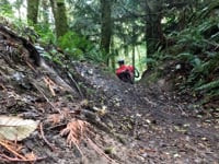
This legacy trail predates the bike park and only received some minor improvements to be included in the bike park. It is a fun intermediate level, hand built trail. It features exposed roots and optional lines.
This trail was historically used by moto riders and you may encounter them here as it is part of a route some local riders still use.
Width: 48" Ave. / 42" Min.
Camber: to 24%
Slope: Down to 34% / Up n/a
12" drops
54" bridge
| c1 | c2 | c3 | c4 |
|---|---|---|---|
January | February | March | April |
May | June | July | August |
September | October | November | December |

Service Road Atlas is a free to use, community-driven service for viewing and creating reports on the numerous back-country service roads around B.C. and Alberta.
Save the current map location and zoom level as your default home location whenever this page is loaded.
SaveWe hope you've been enjoying Trailforks!
Create a FREE account to view trail comments and much more.
You must enter a description before submitting.

