more stats
1.0 mile
Distance
50 ft
Climb
-886 ft
Descent
00:08:00
Avg time
-838 ft
Altitude change
1,167 ft
Altitude min
2,006 ft
Altitude max
2,006 ft
Altitude start
1,168 ft
Altitude end
-15.4%
Grade
-64.3%
Grade max
18.9%
Grade min
410 ft
Distance climb
4,829 ft
Distance down
220 ft
Distance flat
00:08:00
Avg time

Revenant Details

  • Activities
    • Mountain Bike
    • E-Bike
  • Riding Area
    Finale Outdoor Region
    Finale Ligure
  • Ref Number
    #356
  • Difficulty Rating
  • Voted Difficulty
    Red (7 votes)
  • Local Popularity
    100 in Mountain Biking [+]
    • 100 in E-Biking
  • Global Ranking
    #95 in Mountain Biking [+]
    • #1617 in E-Biking
  • Trail Type
    Singletrack
  • Bike Type
    AM
  • Climb Difficulty
    Green
  • Physical Rating
    Moderate
  • Trail Visibility
    Always easy to follow
  • Season
    All-year round
  • Dogs Allowed
    Yes
  • eBike Allowed
    Yes up to Class 1
  • Land Owner
    Finale Outdoor Region

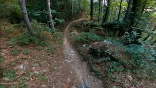
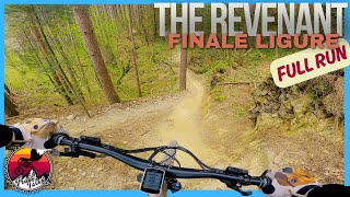
A little more than 1 km, it is the perfect end to an already great trail as Isallo Extasi is. It starts at the end of the tarmac road that leads to the Ferrata degli Artisti and features some gullies, exposed sections, roots and steep bits.
It ends up close to where Toboga di Canova does.

source: ...
Access Info

Exit the E80 highway in Pietra Ligure. Keep going towards the sea and you'll get to Pietra Ligure. You'll then be able to drive toward the mountains in order to reach Val Maremola towns and trails.
Other option would be the E80 exit in Finale Ligure. Keep going towards the sea until you catch the SS1 Via Aurelia and move west until Pietra Ligure.

Disclaimer

Lines can change quickly all of a sudden and you'll also find some exposed sections. Given its nature, the trail can change after weather happenings and season changes. Always pay attention

Trail Supporters
Local Trail Association

Recent Activity on Trail

Past Week
  • 7 rides
  • 27 miles average
6 Months
  • 392 rides
  • 26 miles avg distance
All
  • 1,810 rides
  • Last: Jun 28, 2026
c1c2c3c4
January
February
March
April
May
June
July
August
September
October
November
December
Status:
on Jun 10, 2026
Dry
Avg: 4.77 (79 votes)
Your vote: 0

view (11,153)
close
3D
Trail Conditions
  • Unknown
  • Snow Groomed
  • Snow Packed
  • Snow Covered
  • Snow Cover Partial
  • Freeze/thaw Cycle
  • Icy
  • Prevalent Mud
  • Wet
  • Variable
  • Ideal
  • Dry
  • Very Dry
Trail Flow (Ridden Direction)
Trailforks scans users ridelogs to determine the most popular direction each trail is ridden. A good flowing trail network will have most trails flowing in a single direction according to their intension.
The colour categories are based on what percentage of riders are riding a trail in its intended direction.
  • > 96%
  • > 90%
  • > 80%
  • > 70%
  • > 50%
  • < 50%
  • bi-directional trail
  • no data
Trail Last Ridden
Trailforks scans ridelogs to determine the last time a trail was ridden.
  • < 2 days
  • < 1 week
  • < 2 weeks
  • < 1 month
  • < 6 months
  • > 6 months
Trail Ridden Direction
The intended direction a trail should be ridden.
  • Downhill Only
  • Downhill Primary
  • Both Directions
  • Uphill Primary
  • Uphill Only
  • One Direction
Contribute Details
Colors indicate trail is missing specified detail.
  • Description
  • Photos
  • Description & Photos
  • Videos
Trail Popularity ?
Trailforks scans ridelogs to determine which trails are ridden the most in the last 9 months. Trails are compared with nearby trails in the same city region with a possible 25 colour shades. Think of this as a heatmap, more rides = more kinetic energy = warmer colors.
  • most popular
  • popular
  • less popular
  • not popular
ATV/ORV/OHV Filter
Max Vehicle Width
inches
US Cell Coverage
Legend
cell carrier legend

Radar Time
Activity Recordings
Trailforks uses anonymized public activity data. ?
Activity Recordings
Trailforks uses anonymized public activity data. ?
Personal Heatmap
Activity Types
all / none
Options
2
Date range month
Winter Trails
Warning A routing network for winter maps does not exist. Selecting trails using the winter trails layer has been disabled.
Missing Trails
Most Popular
Least Popular
Trails are colored based on popularity. The more popular a trail is, the more red. Less popular trails trend towards green.
Jump Magnitude Heatmap
Heatmap of where riders jump on trails. Zoom in to see individual jumps, click circles to view jump details.
BC Backroad Status

Service Road Atlas is a free to use, community-driven service for viewing and creating reports on the numerous back-country service roads around B.C. and Alberta.

map legend
Slope Aspect
Direction the slope faces
Flat N NE E SE S SW W NW
Trails Deemphasized
Trails are shown in grey.
disable
Only show trails with no bike usage.
Enable
Suggested Layers
Based on selected activity type

    Save the current map location and zoom level as your default home location whenever this page is loaded.

    Save
        Directions to revenant trailhead (44.206290, 8.202920)

        Photos

        300 more »
        93 |
        May 10, 2025 @ 8:17am
        May 10, 2025
        48 |
        May 10, 2025 @ 8:17am
        May 10, 2025
        60 |
        May 10, 2025 @ 8:17am
        May 10, 2025
        71 |
        May 10, 2025 @ 8:17am
        May 10, 2025

        Videos

        10 more »
        youtuber Revenant - Finale Ligure | Finale Outdoor Region
        4:43 | 334 | Dec 18, 2023 , Finale Ligure
        youtuber Full MTB Descent | Revenant Trail Finale...
        5:15 | 187 | May 17, 2025 , Finale Ligure
        Finale Ligure eMTBing - Trail Revenant (top one!)
        97 | Jun 7, 2025 , Finale Ligure
        Finale Ligure eMTBing - Hot on the tail on...
        8:05 | 60 | Jul 18, 2025 , Finale Ligure

        Trail Lists

        Routes with this trail

        34 miles 8,391 ft 13
        Quäl Dich Du Sau - Trailguides Pfälzerwald präsentieren euch ein Trailfest und eine herrlich Quälerei...
        33 miles 8,773 ft 16 Loop Race
        Percorso 2026 della gara del Valmaremola 54 chilomnetri
        49 miles 9,497 ft 18 Loop Race
        Race course for the Bluegrass Trophy of Nations 2022

        19 Reviews & Comments


        We hope you've been enjoying Trailforks!

        Create a FREE account to view trail comments and much more.

        Frequently Asked Questions About Revenant

        Where is Revenant located?
        Revenant is located in Finale Outdoor Region, Finale Ligure, Italy. It is part of the Finale Outdoor Region trail network. The trailhead is located at coordinates 44.20629, 8.20292.
        How hard is Revenant?
        Revenant is rated as Blue difficulty. The physical rating is Moderate. The average grade is 15.4%. The climb difficulty is rated Green.
        What is the elevation gain for Revenant?
        Revenant has 15 m of elevation gain. The trail has 270 m of elevation descent. The elevation ranges from 356 m to 611 m.
        How long is Revenant?
        Revenant is 1.7 km long. The trail type is singletrack.

        Hit the Trail

        Open in App

        Get this trail on your phone instantly.
        open trail in app

        Download Trail

        Save to wishlist, Garmin & download.
        save the trail

        Find Related Routes

        Find routes and users activities that include this trail.
        find routes for this trail

        You must enter a description before submitting.