more stats
2,014 ft
Distance
3 ft
Climb
-184 ft
Descent
00:07:38
Avg time
-181 ft
Altitude change
269 ft
Altitude min
453 ft
Altitude max
453 ft
Altitude start
272 ft
Altitude end
-9%
Grade
-29.3%
Grade max
2.9%
Grade min
56 ft
Distance climb
1,591 ft
Distance down
325 ft
Distance flat
00:07:38
Avg time

Rhody-O Details

  • Activities
    • Mountain Bike
    • Hike
    • Trail Running
  • Riding Area
    Diamond Hill
    Cumberland, Rhode Island
  • Difficulty Rating
  • Local Popularity
    95 in Mountain Biking [+]
    • 75 in Trail Running
    • 5 in Hiking
  • Global Ranking
    #48655 in Mountain Biking [+]
    • #86811 in Trail Running
    • #214789 in Hiking
  • Trail Type
    Singletrack
  • Bike Type
    DH
  • Direction
    Downhill Only
  • Physical Rating
    Hard
  • Dogs Allowed
    Yes
  • TTFs on Trail
    Drop, Jump, Rock Face

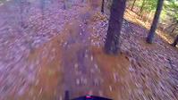
Rhody-O is another one of the original 'Freeride' trails and was the second trail built at DH. The trail descends the fall line on the north side of the quarry through pumpy terrain. You hit a 4-5ft drop about 1/3 of the way down the trail, then pedal across a flat. The trail then descends down a steep roller to a bench cut, then hits two, 2-3 foot drops right in a row before hitting a berm to another hip/ roller finally leading you into a small gap/ stepdown at the bottom of the hill. Great trail

Local Trail Association
Traditionally Indigenous Territory

Recent Activity on Trail

Past Week
  • 1 rides
  • 5 miles average
6 Months
  • 46 rides
  • 7 miles avg distance
All
  • 637 rides
  • Last: Jun 13, 2026
c1c2c3c4
January
February
March
April
May
June
July
August
September
October
November
December
update trails status or condition

Rhody-O Trail Reports

statusdatedescription
Apr 24, 2026 @ 3:41pm (America/New_York)
Apr 24, 2026
Mar 22, 2026 @ 10:42am (America/New_York)
Mar 22, 2026
Jul 19, 2024 @ 1:19pm
Jul 19, 2024
Large tree down on rhody-0, right after the first large roller/drop where it touches white climb
Aug 13, 2023 @ 7:56am
Aug 13, 2023
Some of the rock faces were wet. but no brakes = no problem on those. Trail was a lot of fun.
Aug 5, 2023 @ 6:52am
Aug 5, 2023
LOTs of new clipping, plus some repair of the drop / roller. Running amazing, now!
more »
Status:
on Apr 24, 2026
Ideal
Avg: 4.11 (11 votes)
Your vote: 0

view (3,379)
close
3D
Trail Conditions
  • Unknown
  • Snow Groomed
  • Snow Packed
  • Snow Covered
  • Snow Cover Partial
  • Freeze/thaw Cycle
  • Icy
  • Prevalent Mud
  • Wet
  • Variable
  • Ideal
  • Dry
  • Very Dry
Trail Flow (Ridden Direction)
Trailforks scans users ridelogs to determine the most popular direction each trail is ridden. A good flowing trail network will have most trails flowing in a single direction according to their intension.
The colour categories are based on what percentage of riders are riding a trail in its intended direction.
  • > 96%
  • > 90%
  • > 80%
  • > 70%
  • > 50%
  • < 50%
  • bi-directional trail
  • no data
Trail Last Ridden
Trailforks scans ridelogs to determine the last time a trail was ridden.
  • < 2 days
  • < 1 week
  • < 2 weeks
  • < 1 month
  • < 6 months
  • > 6 months
Trail Ridden Direction
The intended direction a trail should be ridden.
  • Downhill Only
  • Downhill Primary
  • Both Directions
  • Uphill Primary
  • Uphill Only
  • One Direction
Contribute Details
Colors indicate trail is missing specified detail.
  • Description
  • Photos
  • Description & Photos
  • Videos
Trail Popularity ?
Trailforks scans ridelogs to determine which trails are ridden the most in the last 9 months. Trails are compared with nearby trails in the same city region with a possible 25 colour shades. Think of this as a heatmap, more rides = more kinetic energy = warmer colors.
  • most popular
  • popular
  • less popular
  • not popular
ATV/ORV/OHV Filter
Max Vehicle Width
inches
US Cell Coverage
Legend
cell carrier legend

Radar Time
Activity Recordings
Trailforks uses anonymized public activity data. ?
Activity Recordings
Trailforks uses anonymized public activity data. ?
Personal Heatmap
Activity Types
all / none
Options
2
Date range month
Winter Trails
Warning A routing network for winter maps does not exist. Selecting trails using the winter trails layer has been disabled.
Missing Trails
Most Popular
Least Popular
Trails are colored based on popularity. The more popular a trail is, the more red. Less popular trails trend towards green.
Jump Magnitude Heatmap
Heatmap of where riders jump on trails. Zoom in to see individual jumps, click circles to view jump details.
BC Backroad Status

Service Road Atlas is a free to use, community-driven service for viewing and creating reports on the numerous back-country service roads around B.C. and Alberta.

map legend
Slope Aspect
Direction the slope faces
Flat N NE E SE S SW W NW
Trails Deemphasized
Trails are shown in grey.
disable
Only show trails with no bike usage.
Enable
Suggested Layers
Based on selected activity type

    Save the current map location and zoom level as your default home location whenever this page is loaded.

    Save
        Directions to rhodyo trailhead (42.004420, -71.427000)

        Photos

        7 more »
        269 |
        Jan 10, 2023 @ 6:46pm
        Jan 10, 2023
        395 |
        Mar 22, 2021 @ 12:59am
        Mar 22, 2021
        413 |
        Sep 27, 2020 @ 5:51am
        Sep 27, 2020
        733 |
        Dec 14, 2016 @ 2:05pm
        Dec 14, 2016

        Videos

        3 more »
        Rhody-O, Iafrate 2012
        0:16 | 1196 | Oct 30, 2014 , Cumberland
        2016 Diamond Hill Enduro - Stage 3
        0:38 | 644 | Apr 25, 2016 , Cumberland
        DHill - Rhody-O
        0:22 | 904 | Nov 25, 2014 , Cumberland

        Routes with this trail

        5 miles 900 ft 12
        This is the "enduro" loop for the 2023 Fun Ride
        3.0 6 miles 802 ft 14
        A little bit of everything for everyone
        2.0 5 miles 902 ft 14
        RINEMBA Fun Ride for 2022. Enduro Loop.

        1 Review & Comments


        We hope you've been enjoying Trailforks!

        Create a FREE account to view trail comments and much more.

        Frequently Asked Questions About Rhody-O

        Where is Rhody-O located?
        Rhody-O is located in Diamond Hill, Cumberland, Rhode Island, United States. It is part of the Diamond Hill trail network. The trailhead is located at coordinates 42.00442, -71.427.
        How hard is Rhody-O?
        Rhody-O is rated as Double Black Diamond difficulty. The physical rating is Hard. The average grade is 9%.
        What is the elevation gain for Rhody-O?
        Rhody-O has 3 ft of elevation gain. The trail has 184 ft of elevation descent. The elevation ranges from 269 ft to 453 ft.
        Is Rhody-O a point to point trail?
        Yes, Rhody-O is a point to point trail. The direction is Downhill Only. The trail type is singletrack.

        Hit the Trail

        Open in App

        Get this trail on your phone instantly.
        open trail in app

        Download Trail

        Save to wishlist, Garmin & download.
        save the trail

        Find Related Routes

        Find routes and users activities that include this trail.
        find routes for this trail

        You must enter a description before submitting.