more stats
1,696 ft
Distance
-127 ft
Descent
434 ft
High Point
-127 ft
Altitude change
307 ft
Altitude min
434 ft
Altitude start
308 ft
Altitude end
-7.5%
Grade
-17.6%
Grade max
1.5%
Grade min
16 ft
Distance climb
1,473 ft
Distance down
207 ft
Distance flat

Rhythm & Berms Details

  • Activities
    • Mountain Bike
    • E-Bike
    • Adaptive Bike
  • Riding Area
    MTB Tehaleh
    Bonney Lake, Washington
  • Difficulty Rating
  • Voted Difficulty
    Green (1 vote)
  • Local Popularity
    70 in Mountain Biking [+]
    • 60 in E-Biking
  • Trail Type
    Singletrack
  • Bike Type
    DH, AM, XC, Adaptive MTB
  • Climb Difficulty
    Blue
  • Physical Rating
    Easy
  • Trail Visibility
    Always easy to follow
  • eBike Allowed
    Yes up to Class 1
  • TTFs on Trail
    Berm

2024 Singletracks Mountain Bike News Best New Beginner Trail

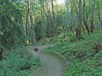
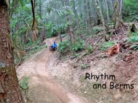
This beginner oriented flow trail is the gateway to all 3 of the freeride/jump trails. After the split, you get a dirt roller-coaster with an emphasis on cornering.
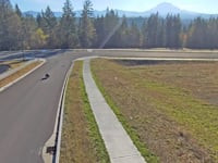
Adaptive Bike Info
aMTB Blue Rating: Intermediate features and steeper terrain.

Camber: Up to 17%
Trail Width: 60" Average, 48" Minimum
Slope: Down to 18%, Up n/a

Adaptive Evaluation Form

View PDF

Local Trail Association
Traditionally Indigenous Territory

Recent Activity on Trail

Past Week
  • 7 rides
  • 7 miles average
6 Months
  • 107 rides
  • 9 miles avg distance
All
  • 420 rides
  • Last: Jun 17, 2026
c1c2c3c4
January
February
March
April
May
June
July
August
September
October
November
December
update trails status or condition

Rhythm & Berms Trail Reports

statusdatedescription
May 27, 2026 @ 6:12pm (America/Vancouver)
May 27, 2026
Funnest berms around E Pierce county! A little chattery in spots - not gravelly - due to just ruts and breaking in the clay, but I was on a...
Apr 28, 2026 @ 8:47pm (America/Los_Angeles)
Apr 28, 2026
Apr 4, 2026 @ 11:38am (America/Vancouver)
Apr 4, 2026
Mar 3, 2026 @ 4:17pm (America/Los_Angeles)
Mar 3, 2026
Feb 23, 2026 @ 1:53pm (America/Los_Angeles)
Feb 23, 2026
Blew off this trail, bacon/pancakes, PBJ, and the climb trail. Tree down on lower rhythm n berm
more »
Status:
on May 27, 2026
Ideal
Avg: 4.45 (5 votes)
Your vote: 0

view (1,659)
close
3D
Trail Conditions
  • Unknown
  • Snow Groomed
  • Snow Packed
  • Snow Covered
  • Snow Cover Partial
  • Freeze/thaw Cycle
  • Icy
  • Prevalent Mud
  • Wet
  • Variable
  • Ideal
  • Dry
  • Very Dry
Trail Flow (Ridden Direction)
Trailforks scans users ridelogs to determine the most popular direction each trail is ridden. A good flowing trail network will have most trails flowing in a single direction according to their intension.
The colour categories are based on what percentage of riders are riding a trail in its intended direction.
  • > 96%
  • > 90%
  • > 80%
  • > 70%
  • > 50%
  • < 50%
  • bi-directional trail
  • no data
Trail Last Ridden
Trailforks scans ridelogs to determine the last time a trail was ridden.
  • < 2 days
  • < 1 week
  • < 2 weeks
  • < 1 month
  • < 6 months
  • > 6 months
Trail Ridden Direction
The intended direction a trail should be ridden.
  • Downhill Only
  • Downhill Primary
  • Both Directions
  • Uphill Primary
  • Uphill Only
  • One Direction
Contribute Details
Colors indicate trail is missing specified detail.
  • Description
  • Photos
  • Description & Photos
  • Videos
Trail Popularity ?
Trailforks scans ridelogs to determine which trails are ridden the most in the last 9 months. Trails are compared with nearby trails in the same city region with a possible 25 colour shades. Think of this as a heatmap, more rides = more kinetic energy = warmer colors.
  • most popular
  • popular
  • less popular
  • not popular
ATV/ORV/OHV Filter
Max Vehicle Width
inches
US Cell Coverage
Legend
cell carrier legend

Radar Time
Activity Recordings
Trailforks uses anonymized public activity data. ?
Activity Recordings
Trailforks uses anonymized public activity data. ?
Personal Heatmap
Activity Types
all / none
Options
2
Date range month
Winter Trails
Warning A routing network for winter maps does not exist. Selecting trails using the winter trails layer has been disabled.
Missing Trails
Most Popular
Least Popular
Trails are colored based on popularity. The more popular a trail is, the more red. Less popular trails trend towards green.
Jump Magnitude Heatmap
Heatmap of where riders jump on trails. Zoom in to see individual jumps, click circles to view jump details.
BC Backroad Status

Service Road Atlas is a free to use, community-driven service for viewing and creating reports on the numerous back-country service roads around B.C. and Alberta.

map legend
Slope Aspect
Direction the slope faces
Flat N NE E SE S SW W NW
Trails Deemphasized
Trails are shown in grey.
disable
Only show trails with no bike usage.
Enable
Suggested Layers
Based on selected activity type

    Save the current map location and zoom level as your default home location whenever this page is loaded.

    Save
        Directions to rhythm--berms trailhead (47.122970, -122.212580)

        Photos

        3 more »
        73 |
        Apr 16, 2024 @ 2:34pm
        Apr 16, 2024
        38 |
        Jan 24, 2025 @ 10:10am
        Jan 24, 2025
        32 |
        Jan 24, 2025 @ 10:05am
        Jan 24, 2025

        Videos

        4 more »
        Skydio Tracking Descent
        0:58 | 66 | Feb 28, 2025 , Bonney Lake
        New Life for an Old Catrike Speed
        3:23 | 191 | Jul 2, 2024 , Bonney Lake
        youtuber Tehaleh | Another New Trail System in Washington!
        19:56 | 117 | Jun 24, 2024 , Bonney Lake
        Rhythm and Berms--Trek at Tehaleh
        2:25 | 118 | Jun 20, 2024 , Bonney Lake

        6 Reviews & Comments


        We hope you've been enjoying Trailforks!

        Create a FREE account to view trail comments and much more.

        Frequently Asked Questions About Rhythm & Berms

        Where is Rhythm & Berms located?
        Rhythm & Berms is located in MTB Tehaleh, Bonney Lake, Washington, United States. It is part of the MTB Tehaleh trail network. The trailhead is located at coordinates 47.12297, -122.21258.
        How hard is Rhythm & Berms?
        Rhythm & Berms is rated as Green difficulty. The physical rating is Easy. The average grade is 7.5%. The climb difficulty is rated Blue.
        What is the elevation gain for Rhythm & Berms?
        The trail has 127 ft of elevation descent. The elevation ranges from 307 ft to 434 ft.
        How long is Rhythm & Berms?
        Rhythm & Berms is 1,696 ft long. The trail type is singletrack.

        Hit the Trail

        Open in App

        Get this trail on your phone instantly.
        open trail in app

        Download Trail

        Save to wishlist, Garmin & download.
        save the trail

        Find Related Routes

        Find routes and users activities that include this trail.
        find routes for this trail

        You must enter a description before submitting.