more stats
2.5 miles
Distance
564 ft
Climb
-255 ft
Descent
00:29:46
Avg time
308 ft
Altitude change
4,725 ft
Altitude min
5,259 ft
Altitude max
4,732 ft
Altitude start
5,039 ft
Altitude end
2.3%
Grade
-46.6%
Grade max
49.9%
Grade min
2 miles
Distance climb
3,448 ft
Distance down
1,552 ft
Distance flat
00:29:46
Avg time

Ridgeback – R3 Details

  • Activities
    • Mountain Bike
    • E-Bike
    • Winter Fat Bike
    • Horse
    • Hike
    • Trail Running
  • Riding Area
    Station Flats
    Bragg Creek, Alberta
  • AKA
    Ridgeback, R3
  • Difficulty Rating
  • Voted Difficulty
    Blue (1 vote)
  • Local Popularity
    65 in Mountain Biking [+]
    • 85 in E-Biking
    • 90 in Trail Running
    • 50 in Hiking
    • 5 in Horseback
  • Global Ranking
    #42615 in Mountain Biking [+]
    • #12662 in E-Biking
    • #48869 in Trail Running
    • #114786 in Hiking
    • #1374 in Horseback
  • Trail Type
    Singletrack
  • Bike Type
    AM, XC, Fat
  • Direction
    Both Directions
    Popular In Reverse
  • Climb Difficulty
    Blue
  • Physical Rating
    Moderate
  • Dogs Allowed
    Yes
  • eBike Allowed
    Yes up to Class 1
  • TTFs on Trail
    Bridge
  • Year Opened
    2009
  • Land Owner
    Alberta Forestry and Parks

Ridgeback is one of the trails in Kananaskis built and maintained by the Calgary Mountain Bike Alliance. It's a mix of machine-built and hand-built construction, designed to provide an alternative to the perpetual wetness of the Tom Snow trail.

Ridgeback and Tom Snow come together at three points, dividing both trails into four sections, all of which are good in either direction. The parts of Tom Snow that Ridgeback bypasses are almost always wet & muddy.

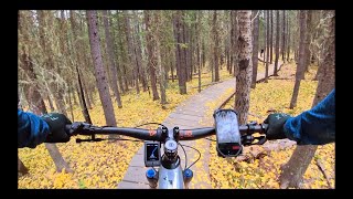
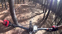
R3 is the longest and hilliest section of Ridgeback. The middle part runs along the ridge which features some rocky sections. The descent to the south features a number of bermed corners and a section of boardwalk.

Access Info

Access from Bobcat or Snakes & Ladders if coming from West Bragg Creek via Ranger Summit, from Ridgeback R1 & R2 to the south (from Station Flats) or from R4 & Moose Packers to the north. Note that Snakes & Ladders joins Ridgeback R3 in the middle, at the north end of the ridge.

Trail Supporters

  • 2009 - 2010
    Builder
Local Trail Association

Recent Activity on Trail

Past Week
  • 1 rides
  • 14.6 km average
6 Months
  • 7 rides
  • 20.5 km avg distance
All
  • 347 rides
  • Last: Jun 26, 2026
c1c2c3c4
January
February
March
April
May
June
July
August
September
October
November
December
update trails status or condition

Ridgeback – R3 Trail Reports

statusdatedescription
May 9, 2026 @ 12:13pm (America/Edmonton)
May 9, 2026
May 8, 2026 @ 5:58pm (America/Edmonton)
May 8, 2026
Four locations with downed trees between Ladders and Bobcat. Trail is dry.
Feb 13, 2026 @ 12:10pm (America/Edmonton)
Feb 13, 2026
Dec 16, 2025 @ 6:40pm (America/Edmonton)
Dec 16, 2025
Snowy and icy near Bobcat end. Bone dry north of logging road crossing. A few trees down.
Nov 10, 2025 @ 3:51pm (America/Edmonton)
Nov 10, 2025
So many down trees. Top of ridge down to Ridgeback 4 is unrideable. I was able to remove 8 smaller diameter trees but about 15 large diameter...
more »
Status:
on May 9, 2026
Dry
Avg: 3.94 (28 votes)
Your vote: 0

view (2,022)
close
3D
Trail Conditions
  • Unknown
  • Snow Groomed
  • Snow Packed
  • Snow Covered
  • Snow Cover Partial
  • Freeze/thaw Cycle
  • Icy
  • Prevalent Mud
  • Wet
  • Variable
  • Ideal
  • Dry
  • Very Dry
Trail Flow (Ridden Direction)
Trailforks scans users ridelogs to determine the most popular direction each trail is ridden. A good flowing trail network will have most trails flowing in a single direction according to their intension.
The colour categories are based on what percentage of riders are riding a trail in its intended direction.
  • > 96%
  • > 90%
  • > 80%
  • > 70%
  • > 50%
  • < 50%
  • bi-directional trail
  • no data
Trail Last Ridden
Trailforks scans ridelogs to determine the last time a trail was ridden.
  • < 2 days
  • < 1 week
  • < 2 weeks
  • < 1 month
  • < 6 months
  • > 6 months
Trail Ridden Direction
The intended direction a trail should be ridden.
  • Downhill Only
  • Downhill Primary
  • Both Directions
  • Uphill Primary
  • Uphill Only
  • One Direction
Contribute Details
Colors indicate trail is missing specified detail.
  • Description
  • Photos
  • Description & Photos
  • Videos
Trail Popularity ?
Trailforks scans ridelogs to determine which trails are ridden the most in the last 9 months. Trails are compared with nearby trails in the same city region with a possible 25 colour shades. Think of this as a heatmap, more rides = more kinetic energy = warmer colors.
  • most popular
  • popular
  • less popular
  • not popular
ATV/ORV/OHV Filter
Max Vehicle Width
inches
US Cell Coverage
Legend
cell carrier legend

Radar Time
Activity Recordings
Trailforks uses anonymized public activity data. ?
Activity Recordings
Trailforks uses anonymized public activity data. ?
Personal Heatmap
Activity Types
all / none
Options
2
Date range month
Winter Trails
Warning A routing network for winter maps does not exist. Selecting trails using the winter trails layer has been disabled.
Missing Trails
Most Popular
Least Popular
Trails are colored based on popularity. The more popular a trail is, the more red. Less popular trails trend towards green.
Jump Magnitude Heatmap
Heatmap of where riders jump on trails. Zoom in to see individual jumps, click circles to view jump details.
BC Backroad Status

Service Road Atlas is a free to use, community-driven service for viewing and creating reports on the numerous back-country service roads around B.C. and Alberta.

map legend
Slope Aspect
Direction the slope faces
Flat N NE E SE S SW W NW
Trails Deemphasized
Trails are shown in grey.
disable
Only show trails with no bike usage.
Enable
Suggested Layers
Based on selected activity type

    Save the current map location and zoom level as your default home location whenever this page is loaded.

    Save
        Directions to ridgeback--r3 trailhead (50.910920, -114.710300)

        Photos

        35 more »
        565 |
        Sep 26, 2016 @ 1:03pm
        Sep 26, 2016
        407 |
        Sep 26, 2016 @ 1:03pm
        Sep 26, 2016
        643 |
        Jul 4, 2013 @ 2:26pm
        Jul 4, 2013
        149 |
        Jun 20, 2021 @ 7:35am
        Jun 20, 2021

        Videos

        4 more »
        Tom Snow to Ridgeback 3, Bragg Creek.
        21:07 | 646 | Oct 10, 2020 , Bragg Creek
        GoPro: Downhill Mountain Biking in Ridgeback...
        967 | Oct 21, 2015 , Bragg Creek
        Edmonton Pinoy MTB, Downhill Mountain Biking...
        805 | Oct 19, 2015 , Bragg Creek
        Ridgeback 3 from YYCMTB
        0:29 | 312 | May 11, 2017 , Bragg Creek

        Routes with this trail

        4.8 13 miles 2,246 ft 7 Loop
        A fun easy loop. I recommend riding counter clockwise. This is also the route for the 2016 Provincial XC...
        4.0 13 miles 2,322 ft 14 Loop
        A loop to do Snakes and Ladders from WBC parking lot.
        11 miles 1,643 ft 7 Loop
        BBB: Bobcat Brew Boundary Ranger > Bobcat > R3 > S&L > Strange Brew > Boundary To maximize...

        1 Review & Comments


        We hope you've been enjoying Trailforks!

        Create a FREE account to view trail comments and much more.

        Frequently Asked Questions About Ridgeback – R3

        Where is Ridgeback – R3 located?
        Ridgeback – R3 is located in Station Flats, Bragg Creek, Alberta, Canada. It is part of the Station Flats trail network. The trailhead is located at coordinates 50.91092, -114.7103.
        How hard is Ridgeback – R3?
        Ridgeback – R3 is rated as Blue difficulty. The physical rating is Moderate. The average grade is 2.3%. The climb difficulty is rated Blue.
        What is the elevation gain for Ridgeback – R3?
        Ridgeback – R3 has 564 ft of elevation gain. The trail has 255 ft of elevation descent. The elevation ranges from 4,725 ft to 5,259 ft.
        Is Ridgeback – R3 a point to point trail?
        Ridgeback – R3 is not a point to point trail. The direction is Both Directions. The trail type is singletrack.

        Hit the Trail

        Open in App

        Get this trail on your phone instantly.
        open trail in app

        Download Trail

        Save to wishlist, Garmin & download.
        save the trail

        Find Related Routes

        Find routes and users activities that include this trail.
        find routes for this trail

        You must enter a description before submitting.