more stats
2.8 miles
Distance
137 ft
Climb
-2,499 ft
Descent
01:10:27
Avg time
-2,362 ft
Altitude change
3,031 ft
Altitude min
5,417 ft
Altitude max
5,417 ft
Altitude start
3,054 ft
Altitude end
-15.8%
Grade
-72.7%
Grade max
28.5%
Grade min
1,900 ft
Distance climb
2 miles
Distance down
735 ft
Distance flat
01:10:27
Avg time

Rifugio Buzzoni Details

  • Activities
    • Mountain Bike
    • E-Bike
    • Hike
    • Trail Running
  • Riding Area
  • Difficulty Rating
  • Local Popularity
    65 in Mountain Biking [+]
    • 65 in E-Biking
    • 75 in Trail Running
    • 60 in Hiking
  • Global Ranking
    #16240 in Mountain Biking [+]
    • #48103 in E-Biking
    • #72178 in Trail Running
    • #89421 in Hiking
  • Hiking SAC Scale
    T2 Mountain Hiking
  • Trail Type
    Singletrack
  • Bike Type
    DH, AM, XC
  • Direction
    Downhill Primary
    Popular Direction Shown
  • Climb Difficulty
    Black Diamond
  • Physical Rating
    Moderate
  • Trail Visibility
    Always easy to follow
  • Alpine Trail
    Yes
  • Dogs Allowed
    Yes
  • TTFs on Trail
    Berm, Bridge, Rock Garden, Roller Coaster, Skinny, Other

singletrack to Rifugio Buzzoni

Livello tecnico: AM, Enduro
Tipo di Terreno: Sentiero, Sterrato, Asfalto
Fontane: Alla partenza e molteplici lungo il percorso
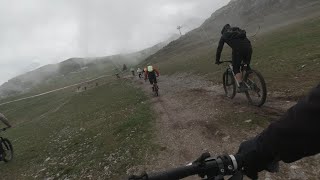
Giunti alla cabinovia la salita non termina, continueremo a salire seguendo la cementata che conduce al centro dello sci di fondo, appena prima del centro svolteremo a sinistra e seguiremo la pista da sci che conduce all'arrivo della seggiovia della valtorta.
Una volta giunti all'arrivo della seggiovia inizierà la prima parte della discesa. In questo primo tratto dopo aver superato un primo tratto pianeggiante inizierà un lungo susseguirsi di sali e scendi su un bellissimo singletrail molto veloce sino ad arrivare all'imbocco del passo del toro dove troveremo dei cartelli che indicano il rifugio Buzzoni

Dal passo del Gandazzo, seguire le indicazioni del segnavia verso il rifugio buzzoni: la prima parte fino al rifugio si presenta con un bellissimo sentiero semplice e largo.
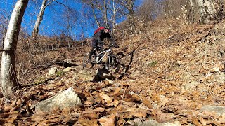
Una volta giunti al rifugio continueremo a scendere seguendo le indicazioni per Introbio e Barzio sino all'alpe Te: questo tratto risulta alternato da tratti molto tecnici con altri piú flow, intervallati da piccoli tornantini e su un fondo molto sassoso.
All'alpe Te svolteremo a sinistra seguendo le indicazioni per Barzio e inizieremo ad affrontare un tratto inizialmente molto veloce che piano piano diventa estremamente tecnico, in alcuni tratti saremo costretti a scendere dalle nostre bici per superare alcuni ostacoli.
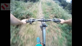
Al termine della discesa arriveremo nei pressi di un ponticello in legno dopo il quale affronteremo un tratto in salita con catene, non vi è alcun tipo di problema nell'affrontarlo e superato inizieremo la discesa finale, molto veloce, sino a ritornare al parcheggio della cabinovia

source: ...
Access Info

Piani di Bobbio, passo Gandazzo
Baite nava di sopra

Disclaimer

Sometimes very closed by vegetations during spring and summer months, be careful to pedestrians.

Recent Activity on Trail

Past Week
  • 0 rides
  •  
6 Months
  • 0 rides
  •  
All
  • 1 rides
  • Last: Oct 3, 2025
c1c2c3c4
January
February
March
April
May
June
July
August
September
October
November
December
update trails status or condition

Rifugio Buzzoni Trail Reports

statusdatedescription
Aug 17, 2025 @ 7:17am
Aug 17, 2025
May 24, 2025 @ 12:44pm
May 24, 2025
Condizioni molto “natural”, Diversi tratti da fare necessariamente a mano, Uno anche particolarmente impegnativo, dato il dissesto e la...
Sep 21, 2024 @ 8:53am
Sep 21, 2024
Jul 15, 2023 @ 3:42am
Jul 15, 2023
May 21, 2023 @ 3:14am
May 21, 2023
reporter
more »
Status:
on Aug 17, 2025
Ideal
Avg: 3.89 (4 votes)
Your vote: 0

view (32)
close
3D
Trail Conditions
  • Unknown
  • Snow Groomed
  • Snow Packed
  • Snow Covered
  • Snow Cover Partial
  • Freeze/thaw Cycle
  • Icy
  • Prevalent Mud
  • Wet
  • Variable
  • Ideal
  • Dry
  • Very Dry
Trail Flow (Ridden Direction)
Trailforks scans users ridelogs to determine the most popular direction each trail is ridden. A good flowing trail network will have most trails flowing in a single direction according to their intension.
The colour categories are based on what percentage of riders are riding a trail in its intended direction.
  • > 96%
  • > 90%
  • > 80%
  • > 70%
  • > 50%
  • < 50%
  • bi-directional trail
  • no data
Trail Last Ridden
Trailforks scans ridelogs to determine the last time a trail was ridden.
  • < 2 days
  • < 1 week
  • < 2 weeks
  • < 1 month
  • < 6 months
  • > 6 months
Trail Ridden Direction
The intended direction a trail should be ridden.
  • Downhill Only
  • Downhill Primary
  • Both Directions
  • Uphill Primary
  • Uphill Only
  • One Direction
Contribute Details
Colors indicate trail is missing specified detail.
  • Description
  • Photos
  • Description & Photos
  • Videos
Trail Popularity ?
Trailforks scans ridelogs to determine which trails are ridden the most in the last 9 months. Trails are compared with nearby trails in the same city region with a possible 25 colour shades. Think of this as a heatmap, more rides = more kinetic energy = warmer colors.
  • most popular
  • popular
  • less popular
  • not popular
ATV/ORV/OHV Filter
Max Vehicle Width
inches
US Cell Coverage
Legend
cell carrier legend

Radar Time
Activity Recordings
Trailforks uses anonymized public activity data. ?
Activity Recordings
Trailforks uses anonymized public activity data. ?
Personal Heatmap
Activity Types
all / none
Options
2
Date range month
Winter Trails
Warning A routing network for winter maps does not exist. Selecting trails using the winter trails layer has been disabled.
Missing Trails
Most Popular
Least Popular
Trails are colored based on popularity. The more popular a trail is, the more red. Less popular trails trend towards green.
Jump Magnitude Heatmap
Heatmap of where riders jump on trails. Zoom in to see individual jumps, click circles to view jump details.
BC Backroad Status

Service Road Atlas is a free to use, community-driven service for viewing and creating reports on the numerous back-country service roads around B.C. and Alberta.

map legend
Slope Aspect
Direction the slope faces
Flat N NE E SE S SW W NW
Trails Deemphasized
Trails are shown in grey.
disable
Only show trails with no bike usage.
Enable
Suggested Layers
Based on selected activity type

    Save the current map location and zoom level as your default home location whenever this page is loaded.

    Save
        Directions to rifugio-buzzoni trailhead (45.982170, 9.498090)

        Photos

        0 more »
        42 |
        May 21, 2023 @ 3:15am
        May 21, 2023
        39 |
        May 21, 2023 @ 3:15am
        May 21, 2023

        Videos

        3 more »
        Raduno MTB ai Piani di Bobbio
        32:45 | 213 | May 29, 2023 , Barzio
        MTB - Piani Bobbio e discesa dal Rif. Buzzoni
        10:48 | 392 | May 18, 2023 , Barzio
        Rifugio Buzzoni - Barzio (MTB)
        10:03 | 306 | Sep 23, 2022 , Barzio

        2 Reviews & Comments


        We hope you've been enjoying Trailforks!

        Create a FREE account to view trail comments and much more.

        • By maooosnowTF Pro NORTHNLINE & contributors
        • #481849 - 1,013 views

        Frequently Asked Questions About Rifugio Buzzoni

        Where is Rifugio Buzzoni located?
        Rifugio Buzzoni is located in Piani di Bobbio, Barzio, Italy. It is part of the Piani di Bobbio trail network. The trailhead is located at coordinates 45.98217, 9.49809.
        How hard is Rifugio Buzzoni?
        Rifugio Buzzoni is rated as Red difficulty. The physical rating is Moderate. The average grade is 15.8%. The climb difficulty is rated Black Diamond.
        What is the elevation gain for Rifugio Buzzoni?
        Rifugio Buzzoni has 42 m of elevation gain. The trail has 762 m of elevation descent. The elevation ranges from 924 m to 1,651 m.
        Is Rifugio Buzzoni a point to point trail?
        Rifugio Buzzoni is not a point to point trail. The direction is Downhill Primary. The trail type is singletrack.

        Hit the Trail

        Open in App

        Get this trail on your phone instantly.
        open trail in app

        Download Trail

        Save to wishlist, Garmin & download.
        save the trail

        Find Related Routes

        Find routes and users activities that include this trail.
        find routes for this trail

        You must enter a description before submitting.