more stats
3,937 ft
Distance
19 ft
Climb
-623 ft
Descent
746 ft
High Point
-604 ft
Altitude change
140 ft
Altitude min
746 ft
Altitude start
141 ft
Altitude end
-15.3%
Grade
-70.5%
Grade max
13.4%
Grade min
410 ft
Distance climb
2,917 ft
Distance down
610 ft
Distance flat

Rimrock – Lower Details

  • Activities
    • Mountain Bike
    • E-Bike
    • Hike
  • Riding Area
  • Difficulty Rating
  • Local Popularity
    45 in Mountain Biking [+]
    • 50 in E-Biking
    • 95 in Hiking
  • Global Ranking
    #24723 in Mountain Biking [+]
    • #76749 in E-Biking
    • #28821 in Hiking
  • Hiking SAC Scale
    T1 Hiking
  • Trail Type
    Singletrack
  • Bike Type
    AM
  • eBike Allowed
    Yes up to Class 1
  • TTFs on Trail
    Berm, Bridge, Drop, Jump, Gap Jump, Rock Face, Rock Garden
  • Year Opened
    2024
  • Land Owner
    Pan Pac Forest Products

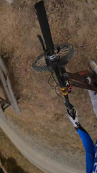
A hand built, descending, narrow single trail. Steeps in places. The trail follows the side of the ridge down, lots of steep dropping switchbacks. Riders need to ride with care. There are large drop-offs in parts at the edge of the trail. The Trail utilises natural features (stumps, limestone rocks, slips, gullies). Natural terrain is preserved as much as possible.Benching is kept to a minimum. Some low berms and catchers.First half has a technical, busy feel. Later stages are more open and faster. Some sections of trail are very narrow, especially on steep faces. The trail finishes with a digger built section with an optional line to some gap jumps.

Access Info

HBMTB Club Membership or MTB Visitor Permit required.

Local Trail Association

Recent Activity on Trail

Past Week
  • 0 rides
  •  
6 Months
  • 3 rides
  • 22.7 km avg distance
All
  • 35 rides
  • Last: Jun 14, 2026
c1c2c3c4
January
February
March
April
May
June
July
August
September
October
November
December
update trails status or condition

Rimrock – Lower Trail Reports

no reports have been added for Rimrock – Lower yet, add a trail report.
Trail reports are used to indicate a trails current condition and inform builders and other riders about any issues on a trail.
Status:
Avg: 4.24 (2 votes)
Your vote: 0

view (174)
close
3D
Trail Conditions
  • Unknown
  • Snow Groomed
  • Snow Packed
  • Snow Covered
  • Snow Cover Partial
  • Freeze/thaw Cycle
  • Icy
  • Prevalent Mud
  • Wet
  • Variable
  • Ideal
  • Dry
  • Very Dry
Trail Flow (Ridden Direction)
Trailforks scans users ridelogs to determine the most popular direction each trail is ridden. A good flowing trail network will have most trails flowing in a single direction according to their intension.
The colour categories are based on what percentage of riders are riding a trail in its intended direction.
  • > 96%
  • > 90%
  • > 80%
  • > 70%
  • > 50%
  • < 50%
  • bi-directional trail
  • no data
Trail Last Ridden
Trailforks scans ridelogs to determine the last time a trail was ridden.
  • < 2 days
  • < 1 week
  • < 2 weeks
  • < 1 month
  • < 6 months
  • > 6 months
Trail Ridden Direction
The intended direction a trail should be ridden.
  • Downhill Only
  • Downhill Primary
  • Both Directions
  • Uphill Primary
  • Uphill Only
  • One Direction
Contribute Details
Colors indicate trail is missing specified detail.
  • Description
  • Photos
  • Description & Photos
  • Videos
Trail Popularity ?
Trailforks scans ridelogs to determine which trails are ridden the most in the last 9 months. Trails are compared with nearby trails in the same city region with a possible 25 colour shades. Think of this as a heatmap, more rides = more kinetic energy = warmer colors.
  • most popular
  • popular
  • less popular
  • not popular
ATV/ORV/OHV Filter
Max Vehicle Width
inches
US Cell Coverage
Legend
cell carrier legend

Radar Time
Activity Recordings
Trailforks uses anonymized public activity data. ?
Activity Recordings
Trailforks uses anonymized public activity data. ?
Personal Heatmap
Activity Types
all / none
Options
2
Date range month
Winter Trails
Warning A routing network for winter maps does not exist. Selecting trails using the winter trails layer has been disabled.
Missing Trails
Most Popular
Least Popular
Trails are colored based on popularity. The more popular a trail is, the more red. Less popular trails trend towards green.
Jump Magnitude Heatmap
Heatmap of where riders jump on trails. Zoom in to see individual jumps, click circles to view jump details.
BC Backroad Status

Service Road Atlas is a free to use, community-driven service for viewing and creating reports on the numerous back-country service roads around B.C. and Alberta.

map legend
Slope Aspect
Direction the slope faces
Flat N NE E SE S SW W NW
Trails Deemphasized
Trails are shown in grey.
disable
Only show trails with no bike usage.
Enable
Suggested Layers
Based on selected activity type

    Save the current map location and zoom level as your default home location whenever this page is loaded.

    Save
        Directions to rimrock--lower trailhead (-39.376400, 176.843580)

        Photos

        1 more »
        52 |
        Jul 8, 2024 @ 2:08am
        Jul 8, 2024

        Videos

        2 more »
        Rim Rock 2024 // Pan Pac MTB
        11:38 | 120 | Sep 22, 2024 , Napier
        Rimrock
        4:00 | 69 | Jul 8, 2024 , Napier

        Reviews / Comments

        No reviews yet, be the first to write a review or ask a question.
        Use trail reports to comment on trail conditions.


        We hope you've been enjoying Trailforks!

        Create a FREE account to view trail comments and much more.

        • By JunoNZTF Pro HBMTBC & contributors
        • #742784 - 388 views

        Frequently Asked Questions About Rimrock – Lower

        Where is Rimrock – Lower located?
        Rimrock – Lower is located in Pan Pac MTB Park, Napier, New Zealand. It is part of the Pan Pac MTB Park trail network. The trailhead is located at coordinates -39.3764, 176.84358.
        How hard is Rimrock – Lower?
        Rimrock – Lower is rated as Black Diamond difficulty. The average grade is 15.3%.
        What is the elevation gain for Rimrock – Lower?
        Rimrock – Lower has 19 ft of elevation gain. The trail has 623 ft of elevation descent. The elevation ranges from 140 ft to 746 ft.
        How long is Rimrock – Lower?
        Rimrock – Lower is 3,937 ft long. The trail type is singletrack.

        Hit the Trail

        Open in App

        Get this trail on your phone instantly.
        open trail in app

        Download Trail

        Save to wishlist, Garmin & download.
        save the trail

        Find Related Routes

        Find routes and users activities that include this trail.
        find routes for this trail

        You must enter a description before submitting.