more stats
5.7 miles
Distance
268 ft
Climb
-1,776 ft
Descent
00:37:54
Avg time
-1,508 ft
Altitude change
6,358 ft
Altitude min
8,036 ft
Altitude max
7,865 ft
Altitude start
6,358 ft
Altitude end
-5%
Grade
-37.9%
Grade max
22.8%
Grade min
4,314 ft
Distance climb
5 miles
Distance down
2,024 ft
Distance flat
00:37:54
Avg time

Ringtail Details

  • Activities
    • Mountain Bike
    • Winter Fat Bike
    • Hike
    • Trail Running
  • Riding Area
    Neslon Ranch Open Space
    Roxborough, Colorado
  • Difficulty Rating
  • Voted Difficulty
    Blue (1 vote)
  • Local Popularity
    90 in Mountain Biking [+]
    • 5 in Trail Running
    • 85 in Hiking
  • Global Ranking
    #44979 in Mountain Biking [+]
    • #34601 in Trail Running
    • #21924 in Hiking
  • Trail Type
    Singletrack
  • Bike Type
    AM, XC, Fat
  • Direction
    Both Directions
  • Climb Difficulty
    Blue
  • Physical Rating
    Moderate
  • Trail Visibility
    Always easy to follow
  • Dogs Allowed
    Yes
  • eBike Allowed

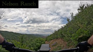
After a few switchbacks and a small amount of climbing, to gain the ridge, enjoy a couple miles of rolling single track within pine and aspen forest with many columbines (mid summer) blossoming. The trail switches between the north and south sides of the ridge before turning north for the multi-mile vertical descent. Foliage changes to gamble oak and the trail conditions change to a mix of rocky, loose gravel and clay with several switchbacks. You can't miss the incredible views of the rocks at Roxborough State Park. The remainder of the trail is tight single track running through a grassland area with wildflowers during summer and beautiful sumac in the fall.

Access Info

Parking is available in the lot (free) just south of 67 on Rampart Range Rd or in the the Indian Creek Campground lot (pay). From the Rampart Range lot, either ride the road down to the Indian Creek Lot or take FS 512 on the north side of 67. From the Indian Creek Lot, take Stevens Gulch Lower trail which begins just north of the bathroom. Either of these routes will take you up to a cleared area where the Ringtail trail begins.

Trail Supporters

  • USFS
    Land Manager
Local Trail Association

Recent Activity on Trail

Past Week
  • 0 rides
  •  
6 Months
  • 12 rides
  • 22 miles avg distance
All
  • 111 rides
  • Last: Jun 17, 2026
c1c2c3c4
January
February
March
April
May
June
July
August
September
October
November
December
update trails status or condition

Ringtail Trail Reports

statusdatedescription
Feb 15, 2026 @ 11:48am (America/Denver)
Feb 15, 2026
Almost all dry, just a few spots of mud or snow/snirt.
Jun 28, 2025 @ 8:25am
Jun 28, 2025
Loose and dry on lower half
Sep 12, 2023 @ 9:06am
Sep 12, 2023
Great shape right now.
Aug 12, 2023 @ 4:17am
Aug 12, 2023
Enjoy this
Jun 23, 2023 @ 10:30am
Jun 23, 2023
Sunny exposed already dried particularly on the Ringtail side facing East. Ringtail is very overgrown on the East slopes. Although tacky, lowest...
more »
Status:
on Feb 15, 2026
Ideal
Avg: 3.99 (5 votes)
Your vote: 0

view (794)
close
3D
Trail Conditions
  • Unknown
  • Snow Groomed
  • Snow Packed
  • Snow Covered
  • Snow Cover Partial
  • Freeze/thaw Cycle
  • Icy
  • Prevalent Mud
  • Wet
  • Variable
  • Ideal
  • Dry
  • Very Dry
Trail Flow (Ridden Direction)
Trailforks scans users ridelogs to determine the most popular direction each trail is ridden. A good flowing trail network will have most trails flowing in a single direction according to their intension.
The colour categories are based on what percentage of riders are riding a trail in its intended direction.
  • > 96%
  • > 90%
  • > 80%
  • > 70%
  • > 50%
  • < 50%
  • bi-directional trail
  • no data
Trail Last Ridden
Trailforks scans ridelogs to determine the last time a trail was ridden.
  • < 2 days
  • < 1 week
  • < 2 weeks
  • < 1 month
  • < 6 months
  • > 6 months
Trail Ridden Direction
The intended direction a trail should be ridden.
  • Downhill Only
  • Downhill Primary
  • Both Directions
  • Uphill Primary
  • Uphill Only
  • One Direction
Contribute Details
Colors indicate trail is missing specified detail.
  • Description
  • Photos
  • Description & Photos
  • Videos
Trail Popularity ?
Trailforks scans ridelogs to determine which trails are ridden the most in the last 9 months. Trails are compared with nearby trails in the same city region with a possible 25 colour shades. Think of this as a heatmap, more rides = more kinetic energy = warmer colors.
  • most popular
  • popular
  • less popular
  • not popular
ATV/ORV/OHV Filter
Max Vehicle Width
inches
US Cell Coverage
Legend
cell carrier legend

Radar Time
Activity Recordings
Trailforks uses anonymized public activity data. ?
Activity Recordings
Trailforks uses anonymized public activity data. ?
Personal Heatmap
Activity Types
all / none
Options
2
Date range month
Winter Trails
Warning A routing network for winter maps does not exist. Selecting trails using the winter trails layer has been disabled.
Missing Trails
Most Popular
Least Popular
Trails are colored based on popularity. The more popular a trail is, the more red. Less popular trails trend towards green.
Jump Magnitude Heatmap
Heatmap of where riders jump on trails. Zoom in to see individual jumps, click circles to view jump details.
BC Backroad Status

Service Road Atlas is a free to use, community-driven service for viewing and creating reports on the numerous back-country service roads around B.C. and Alberta.

map legend
Slope Aspect
Direction the slope faces
Flat N NE E SE S SW W NW
Trails Deemphasized
Trails are shown in grey.
disable
Only show trails with no bike usage.
Enable
Suggested Layers
Based on selected activity type

    Save the current map location and zoom level as your default home location whenever this page is loaded.

    Save
        Directions to ringtail-79421 trailhead (39.389970, -105.101700)

        Photos

        23 more »
        214 |
        Nov 11, 2021 @ 9:12pm
        Nov 11, 2021
        179 |
        Nov 11, 2021 @ 9:12pm
        Nov 11, 2021
        225 |
        Nov 11, 2021 @ 9:11pm
        Nov 11, 2021
        297 |
        Aug 9, 2020 @ 7:35pm
        Aug 9, 2020

        Videos

        1 more »
        Ringtail - Half Hour Blue Flow Descent -...
        12:35 | 133 | Jun 7, 2024 , Roxborough

        Routes with this trail

        5.0 38 miles 7,683 ft 12
        An amazing loop that has it all. Great climbs, epic views, rippin descents, a variety of wildlife, lots of...
        19 miles 3,450 ft 3
        The long version of the Roxborough loop. Climbing roundup instead of .
        2.5 20 miles 3,626 ft 10
        CCW, skirts the upper part of Roxy State Park.

        7 Reviews & Comments


        We hope you've been enjoying Trailforks!

        Create a FREE account to view trail comments and much more.

        • By toddTF Pro Trailforks & contributors
        • #79421 - 4,593 views

        Frequently Asked Questions About Ringtail

        Where is Ringtail located?
        Ringtail is located in Neslon Ranch Open Space, Roxborough, Colorado, United States. It is part of the Neslon Ranch Open Space trail network. The trailhead is located at coordinates 39.38997, -105.1017.
        How hard is Ringtail?
        Ringtail is rated as Blue difficulty. The physical rating is Moderate. The average grade is 5%. The climb difficulty is rated Blue.
        What is the elevation gain for Ringtail?
        Ringtail has 268 ft of elevation gain. The trail has 1,776 ft of elevation descent. The elevation ranges from 6,358 ft to 8,036 ft.
        Is Ringtail a point to point trail?
        Ringtail is not a point to point trail. The direction is Both Directions. The trail type is singletrack.

        Hit the Trail

        Open in App

        Get this trail on your phone instantly.
        open trail in app

        Download Trail

        Save to wishlist, Garmin & download.
        save the trail

        Find Related Routes

        Find routes and users activities that include this trail.
        find routes for this trail

        You must enter a description before submitting.