more stats
2.1 miles
Distance
257 ft
Climb
-412 ft
Descent
00:20:43
Avg time
-156 ft
Altitude change
7,355 ft
Altitude min
7,703 ft
Altitude max
7,510 ft
Altitude start
7,356 ft
Altitude end
-1.4%
Grade
-24.5%
Grade max
19.5%
Grade min
4,623 ft
Distance climb
1 mile
Distance down
551 ft
Distance flat
00:20:43
Avg time

Rip and Tear Details

  • Activities
    • Mountain Bike
    • Gravel Bike
    • Adaptive Bike
    • Winter Fat Bike
    • Hike
    • Trail Running
  • Riding Area
    Galena Lodge
    Ketchum, Idaho
  • Difficulty Rating
  • Voted Difficulty
    Blue (1 vote)
  • Local Popularity
    95 in Mountain Biking [+]
    • 5 in Trail Running
    • 70 in Hiking
  • Global Ranking
    #37644 in Mountain Biking [+]
    • #137087 in Trail Running
    • #96349 in Hiking
  • Hiking SAC Scale
    T2 Mountain Hiking
  • Trail Type
    Singletrack
  • Bike Type
    AM, XC, Fat, Adaptive MTB, CX, Gravel
  • Direction
    Downhill Primary[+]
    Popular Direction Shown
    • Downhill Primary for Gravel Biking
  • Climb Difficulty
    Blue
  • Physical Rating
    Moderate
  • Trail Visibility
    Always easy to follow
  • Season
    June-Oct
  • Dogs Allowed
    Yes
  • eBike Allowed
  • TTFs on Trail
    Berm, Drop, Jump
  • Land Owner
    USFS

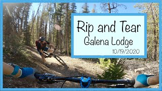
Rip and Tear is an intermediate trail that contains lots of flow. It can be ridden in a variety of ways. You can ride it as a loop (clockwise is best), from the Spring Creek junction down into Gladiator, or from the Spring Creek junction down to Galena View loop. The section between Spring Creek junction and Honeymoon Yurt (on FSR 190) is recommended downhill biking only as it has big berms, jumps, and rollers not suitable for climbing or hiking.

Hikers are recommended to use Rip and Tear trail to hike to and from their yurts up on the ridge.

Like all of the singletrack trails at Galena, the Rip and Tear Trail is open to two-way traffic and shared use by hikers, horseback riders, runners, and bicyclists. Watch for and yield to others - on this and all trails. All Galena singletrack trails are closed to E-Bikes.

Access Info

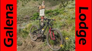
Access from Gladiator, Spring Creek, Shortcut, FSR 190, or the Lodge.

Disclaimer

The USFS has implemented the Big Wood Travel Plan which includes decommissioning many old mining roads in the area.

Adaptive Bike Info
aMTB Green Rating: Beginner features and moderate terrain.

Some obstacles exist but this remains a popular trail for aMTB riders due to its wide trail tread and gentle grade.

Trail Supporters

  • USFS
    Land Manager
Local Trail Association
Traditionally Indigenous Territory

Recent Activity on Trail

Past Week
  • 5 rides
  • 6 miles average
6 Months
  • 14 rides
  • 7 miles avg distance
All
  • 311 rides
  • Last: Jun 24, 2026
c1c2c3c4
January
February
March
April
May
June
July
August
September
October
November
December
update trails status or condition

Rip and Tear Trail Reports

statusdatedescription
Jun 2, 2026 @ 11:35am (America/Boise)
Jun 2, 2026
Clear according to BCRD. Its really too bad that they aren't crossposting as conditions change.
May 16, 2026 @ 11:00am (America/Boise)
May 16, 2026
Rode this as part of the grinder loop. A lot of downfall over the trail, some easy to hop over but some was big enough to need to fully get off...
Oct 30, 2025 @ 2:15pm (America/Boise)
Oct 30, 2025
Snow covered and will not melt out until spring.
Jun 30, 2025 @ 7:00pm
Jun 30, 2025
May 25, 2025 @ 2:42pm
May 25, 2025
Still a fair amount of snow and downed trees, worth bringing a saw
more »
Status:
on Jun 2, 2026
Ideal
Avg: 4.22 (12 votes)
Your vote: 0

view (1,432)
close
3D
Trail Conditions
  • Unknown
  • Snow Groomed
  • Snow Packed
  • Snow Covered
  • Snow Cover Partial
  • Freeze/thaw Cycle
  • Icy
  • Prevalent Mud
  • Wet
  • Variable
  • Ideal
  • Dry
  • Very Dry
Trail Flow (Ridden Direction)
Trailforks scans users ridelogs to determine the most popular direction each trail is ridden. A good flowing trail network will have most trails flowing in a single direction according to their intension.
The colour categories are based on what percentage of riders are riding a trail in its intended direction.
  • > 96%
  • > 90%
  • > 80%
  • > 70%
  • > 50%
  • < 50%
  • bi-directional trail
  • no data
Trail Last Ridden
Trailforks scans ridelogs to determine the last time a trail was ridden.
  • < 2 days
  • < 1 week
  • < 2 weeks
  • < 1 month
  • < 6 months
  • > 6 months
Trail Ridden Direction
The intended direction a trail should be ridden.
  • Downhill Only
  • Downhill Primary
  • Both Directions
  • Uphill Primary
  • Uphill Only
  • One Direction
Contribute Details
Colors indicate trail is missing specified detail.
  • Description
  • Photos
  • Description & Photos
  • Videos
Trail Popularity ?
Trailforks scans ridelogs to determine which trails are ridden the most in the last 9 months. Trails are compared with nearby trails in the same city region with a possible 25 colour shades. Think of this as a heatmap, more rides = more kinetic energy = warmer colors.
  • most popular
  • popular
  • less popular
  • not popular
ATV/ORV/OHV Filter
Max Vehicle Width
inches
US Cell Coverage
Legend
cell carrier legend

Radar Time
Activity Recordings
Trailforks uses anonymized public activity data. ?
Activity Recordings
Trailforks uses anonymized public activity data. ?
Personal Heatmap
Activity Types
all / none
Options
2
Date range month
Winter Trails
Warning A routing network for winter maps does not exist. Selecting trails using the winter trails layer has been disabled.
Missing Trails
Most Popular
Least Popular
Trails are colored based on popularity. The more popular a trail is, the more red. Less popular trails trend towards green.
Jump Magnitude Heatmap
Heatmap of where riders jump on trails. Zoom in to see individual jumps, click circles to view jump details.
BC Backroad Status

Service Road Atlas is a free to use, community-driven service for viewing and creating reports on the numerous back-country service roads around B.C. and Alberta.

map legend
Slope Aspect
Direction the slope faces
Flat N NE E SE S SW W NW
Trails Deemphasized
Trails are shown in grey.
disable
Only show trails with no bike usage.
Enable
Suggested Layers
Based on selected activity type

    Save the current map location and zoom level as your default home location whenever this page is loaded.

    Save
        Directions to rip-and-tear trailhead (43.883590, -114.653180)

        Photos

        11 more »
        9 |
        Jun 7, 2026 @ 7:48pm
        Jun 7, 2026
        49 |
        Aug 12, 2025 @ 12:07pm
        Aug 12, 2025
        187 |
        Sep 24, 2020 @ 12:12pm
        Sep 24, 2020
        159 |
        Aug 3, 2019 @ 3:55pm
        Aug 3, 2019

        Videos

        3 more »
        Idaho Flow Trail || Rip and Tear ||...
        0:55 | 382 | Jun 25, 2022 , Ketchum
        Rip and Tear- Galena Lodge
        4:07 | 519 | Nov 16, 2020 , Ketchum
        If Heaven Has Flow Trails! Mountain Biking...
        30:44 | 256 | Aug 9, 2020 , Ketchum

        Routes with this trail

        Queen's Stage 1 Archived
        43 miles 3,841 ft 4 Race
        First stage of the Queens Stage Race of Rebecca's Private Idaho. For more info use the link on this page.

        5 Reviews & Comments


        We hope you've been enjoying Trailforks!

        Create a FREE account to view trail comments and much more.

        • By jandashetlerTF Pro & contributors
        • #54201 - 3,320 views

        Frequently Asked Questions About Rip and Tear

        Where is Rip and Tear located?
        Rip and Tear is located in Galena Lodge, Ketchum, Idaho, United States. It is part of the Galena Lodge trail network. The trailhead is located at coordinates 43.88359, -114.65318.
        How hard is Rip and Tear?
        Rip and Tear is rated as Blue difficulty. The physical rating is Moderate. The average grade is 1.4%. The climb difficulty is rated Blue.
        What is the elevation gain for Rip and Tear?
        Rip and Tear has 257 ft of elevation gain. The trail has 412 ft of elevation descent. The elevation ranges from 7,355 ft to 7,703 ft.
        Is Rip and Tear a point to point trail?
        Rip and Tear is not a point to point trail. The direction is Downhill Primary. The trail type is singletrack.

        Hit the Trail

        Open in App

        Get this trail on your phone instantly.
        open trail in app

        Download Trail

        Save to wishlist, Garmin & download.
        save the trail

        Find Related Routes

        Find routes and users activities that include this trail.
        find routes for this trail

        You must enter a description before submitting.