more stats
1.4 miles
Distance
186 ft
Climb
-219 ft
Descent
00:17:53
Avg time
-32 ft
Altitude change
383 ft
Altitude min
564 ft
Altitude max
421 ft
Altitude start
390 ft
Altitude end
-0.4%
Grade
-24.5%
Grade max
19.6%
Grade min
3,091 ft
Distance climb
3,268 ft
Distance down
1,079 ft
Distance flat
00:17:53
Avg time

River Track Details

  • Activities
    • Mountain Bike
    • E-Bike
    • Trail Running
  • Riding Area
    Hunua Trails
    Auckland
  • Difficulty Rating
  • Local Popularity
    50 in Mountain Biking [+]
    • 45 in E-Biking
  • Global Ranking
    #86453 in Mountain Biking [+]
    • #80469 in E-Biking
  • Trail Type
    Singletrack
  • Bike Type
    XC
  • Climb Difficulty
    Blue
  • Physical Rating
    Moderate
  • Trail Visibility
    Always easy to follow
  • Dogs Allowed
    Yes
  • eBike Allowed
  • TTFs on Trail
    Bridge, Other
  • Ride in Rain
    Yes

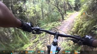
This track cuts out 2km of road and replaces with sweet single-track through regenerating bush. Some of the track is open and flowing while other sections are tight and steep.

there is a river crossing nearly at the end.

source: Auckland MTB
Local Trail Association
  • trail association logo
  • Please consider joining or donating to the local trail association to support
    trail development & maintenance.

Recent Activity on Trail

Past Week
  • 1 rides
  • 16 miles average
6 Months
  • 11 rides
  • 14 miles avg distance
All
  • 106 rides
  • Last: Jun 26, 2026
c1c2c3c4
January
February
March
April
May
June
July
August
September
October
November
December
update trails status or condition

River Track Trail Reports

statusdatedescription
Nov 19, 2025 @ 5:07pm (Pacific/Auckland)
Nov 18, 2025
Oct 16, 2025 @ 12:00pm (Pacific/Auckland)
Oct 15, 2025
Hunua Ranges Regional Park pest control project: closed for a major pest control operation. All tracks will remain closed while we carry out a...
Nov 24, 2023 @ 5:07pm
Nov 24, 2023
Track bypass and infrastructure protection works completed
Nov 4, 2023 @ 7:31pm
Nov 4, 2023
no signage to say its closed but theres a digger / massive piles of gravel where the new diversion is being made but not yet finished. suggest...
Sep 22, 2023 @ 3:34pm
Sep 22, 2023
more »
Status:
on Nov 19, 2025
Avg: 3.85 (8 votes)
Your vote: 0

view (780)
close
3D
Trail Conditions
  • Unknown
  • Snow Groomed
  • Snow Packed
  • Snow Covered
  • Snow Cover Partial
  • Freeze/thaw Cycle
  • Icy
  • Prevalent Mud
  • Wet
  • Variable
  • Ideal
  • Dry
  • Very Dry
Trail Flow (Ridden Direction)
Trailforks scans users ridelogs to determine the most popular direction each trail is ridden. A good flowing trail network will have most trails flowing in a single direction according to their intension.
The colour categories are based on what percentage of riders are riding a trail in its intended direction.
  • > 96%
  • > 90%
  • > 80%
  • > 70%
  • > 50%
  • < 50%
  • bi-directional trail
  • no data
Trail Last Ridden
Trailforks scans ridelogs to determine the last time a trail was ridden.
  • < 2 days
  • < 1 week
  • < 2 weeks
  • < 1 month
  • < 6 months
  • > 6 months
Trail Ridden Direction
The intended direction a trail should be ridden.
  • Downhill Only
  • Downhill Primary
  • Both Directions
  • Uphill Primary
  • Uphill Only
  • One Direction
Contribute Details
Colors indicate trail is missing specified detail.
  • Description
  • Photos
  • Description & Photos
  • Videos
Trail Popularity ?
Trailforks scans ridelogs to determine which trails are ridden the most in the last 9 months. Trails are compared with nearby trails in the same city region with a possible 25 colour shades. Think of this as a heatmap, more rides = more kinetic energy = warmer colors.
  • most popular
  • popular
  • less popular
  • not popular
ATV/ORV/OHV Filter
Max Vehicle Width
inches
US Cell Coverage
Legend
cell carrier legend

Radar Time
Activity Recordings
Trailforks uses anonymized public activity data. ?
Activity Recordings
Trailforks uses anonymized public activity data. ?
Personal Heatmap
Activity Types
all / none
Options
2
Date range month
Winter Trails
Warning A routing network for winter maps does not exist. Selecting trails using the winter trails layer has been disabled.
Missing Trails
Most Popular
Least Popular
Trails are colored based on popularity. The more popular a trail is, the more red. Less popular trails trend towards green.
Jump Magnitude Heatmap
Heatmap of where riders jump on trails. Zoom in to see individual jumps, click circles to view jump details.
BC Backroad Status

Service Road Atlas is a free to use, community-driven service for viewing and creating reports on the numerous back-country service roads around B.C. and Alberta.

map legend
Slope Aspect
Direction the slope faces
Flat N NE E SE S SW W NW
Trails Deemphasized
Trails are shown in grey.
disable
Only show trails with no bike usage.
Enable
Suggested Layers
Based on selected activity type

    Save the current map location and zoom level as your default home location whenever this page is loaded.

    Save
        Directions to river-track-23449 trailhead (-37.101240, 175.154770)

        Photos

        5 more »
        92 |
        May 1, 2021 @ 1:24pm
        May 1, 2021
        74 |
        Jan 22, 2021 @ 10:02pm
        Jan 22, 2021
        34 |
        Apr 14, 2023 @ 1:01am
        Apr 14, 2023
        36 |
        Apr 14, 2023 @ 1:01am
        Apr 14, 2023

        Videos

        1 more »
        Hunua River Track MTB
        7:19 | 1869 | Oct 21, 2018 , Auckland

        Routes with this trail

        12 miles 1,699 ft 10 Loop
        Good 20km Loop taking most of the Hunua Tracks

        1 Review & Comments


        We hope you've been enjoying Trailforks!

        Create a FREE account to view trail comments and much more.

        • By mbl77TF Pro PCBC & contributors
        • #23449 - 2,489 views

        Frequently Asked Questions About River Track

        Where is River Track located?
        River Track is located in Hunua Trails, Auckland, New Zealand. It is part of the Hunua Trails trail network. The trailhead is located at coordinates -37.10124, 175.15477.
        How hard is River Track?
        River Track is rated as Blue difficulty. The physical rating is Moderate. The average grade is 0.4%. The climb difficulty is rated Blue.
        What is the elevation gain for River Track?
        River Track has 186 ft of elevation gain. The trail has 219 ft of elevation descent. The elevation ranges from 383 ft to 564 ft.
        How long is River Track?
        River Track is 1.4 miles long. The trail type is singletrack.

        Hit the Trail

        Open in App

        Get this trail on your phone instantly.
        open trail in app

        Download Trail

        Save to wishlist, Garmin & download.
        save the trail

        Find Related Routes

        Find routes and users activities that include this trail.
        find routes for this trail

        You must enter a description before submitting.