more stats
2,451 ft
Distance
-138 ft
Descent
00:02:59
Avg time
-139 ft
Altitude change
1,114 ft
Altitude min
1,253 ft
Altitude max
1,253 ft
Altitude start
1,115 ft
Altitude end
-5.7%
Grade
-24.4%
Grade max
0.9%
Grade min
2,113 ft
Distance down
292 ft
Distance flat
00:02:59
Avg time

Rock Soft Details

  • Activities
    • Mountain Bike
    • E-Bike
    • Adaptive Bike
  • Riding Area
    Coler Mountain Bike Preserve
    Bentonville, Arkansas
  • Difficulty Rating
  • Voted Difficulty
    Black Diamond (4 votes)
  • Local Popularity
    70 in Mountain Biking [+]
    • 80 in E-Biking
  • Global Ranking
    #3228 in Mountain Biking [+]
    • #1483 in E-Biking
  • Trail Type
    Singletrack
  • Bike Type
  • Direction
    Downhill Only
    Popular Direction Shown
  • Dogs Allowed
    Yes
  • eBike Allowed
    Yes up to Class 1

No community description for Rock Soft trail has been added yet!

AI Generated Description

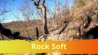
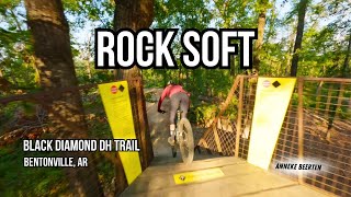
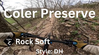
Rock Soft is a highly rated 2,451 ft popular black diamond difficulty singletrack trail located near Bentonville Arkansas. This mountain bike primary trail can be used downhill only. Adaptive MTB rating: amtb blue. On average it takes 2 minutes to complete this trail.

Adaptive Bike Info
aMTB Blue Rating: Intermediate features and steeper terrain.

With near future updates and practice some aMTB's will be able to solo this trail, but bring a support rider first few times.

Local Trail Association

Recent Activity on Trail

Past Week
  • 6 rides
  • 13 miles average
6 Months
  • 145 rides
  • 13 miles avg distance
All
  • 1,387 rides
  • Last: Jun 13, 2026
c1c2c3c4
January
February
March
April
May
June
July
August
September
October
November
December
Status:
on Jun 3, 2026
Variable
Avg: 4.17 (24 votes)
Your vote: 0

view (16,817)
close
3D
Trail Conditions
  • Unknown
  • Snow Groomed
  • Snow Packed
  • Snow Covered
  • Snow Cover Partial
  • Freeze/thaw Cycle
  • Icy
  • Prevalent Mud
  • Wet
  • Variable
  • Ideal
  • Dry
  • Very Dry
Trail Flow (Ridden Direction)
Trailforks scans users ridelogs to determine the most popular direction each trail is ridden. A good flowing trail network will have most trails flowing in a single direction according to their intension.
The colour categories are based on what percentage of riders are riding a trail in its intended direction.
  • > 96%
  • > 90%
  • > 80%
  • > 70%
  • > 50%
  • < 50%
  • bi-directional trail
  • no data
Trail Last Ridden
Trailforks scans ridelogs to determine the last time a trail was ridden.
  • < 2 days
  • < 1 week
  • < 2 weeks
  • < 1 month
  • < 6 months
  • > 6 months
Trail Ridden Direction
The intended direction a trail should be ridden.
  • Downhill Only
  • Downhill Primary
  • Both Directions
  • Uphill Primary
  • Uphill Only
  • One Direction
Contribute Details
Colors indicate trail is missing specified detail.
  • Description
  • Photos
  • Description & Photos
  • Videos
Trail Popularity ?
Trailforks scans ridelogs to determine which trails are ridden the most in the last 9 months. Trails are compared with nearby trails in the same city region with a possible 25 colour shades. Think of this as a heatmap, more rides = more kinetic energy = warmer colors.
  • most popular
  • popular
  • less popular
  • not popular
ATV/ORV/OHV Filter
Max Vehicle Width
inches
US Cell Coverage
Legend
cell carrier legend

Radar Time
Activity Recordings
Trailforks uses anonymized public activity data. ?
Activity Recordings
Trailforks uses anonymized public activity data. ?
Personal Heatmap
Activity Types
all / none
Options
2
Date range month
Winter Trails
Warning A routing network for winter maps does not exist. Selecting trails using the winter trails layer has been disabled.
Missing Trails
Most Popular
Least Popular
Trails are colored based on popularity. The more popular a trail is, the more red. Less popular trails trend towards green.
Jump Magnitude Heatmap
Heatmap of where riders jump on trails. Zoom in to see individual jumps, click circles to view jump details.
BC Backroad Status

Service Road Atlas is a free to use, community-driven service for viewing and creating reports on the numerous back-country service roads around B.C. and Alberta.

map legend
Slope Aspect
Direction the slope faces
Flat N NE E SE S SW W NW
Trails Deemphasized
Trails are shown in grey.
disable
Only show trails with no bike usage.
Enable
Suggested Layers
Based on selected activity type

    Save the current map location and zoom level as your default home location whenever this page is loaded.

    Save
        Directions to rock-soft trailhead (36.391390, -94.236500)

        Photos

        3 more »
        239 |
        Jun 16, 2021 @ 4:54pm
        Jun 16, 2021
        277 |
        Jun 16, 2021 @ 4:52pm
        Jun 16, 2021
        542 |
        May 23, 2020 @ 3:42pm
        May 23, 2020

        Videos

        10 more »
        Rock Soft, Coler Mountain Bike Preserve,...
        0:37 | 132 | Feb 21, 2025 , Bentonville
        ROCK SOFT - Black DH trail at Coler MTB Preserve
        3:21 | 208 | Sep 5, 2024 , Bentonville
        Rock Soft | Full Trail Coler Preserve Mountain...
        2:39 | 157 | May 19, 2024 , Bentonville
        Rock Soft - The Hub - Coler Preserve
        2:49 | 108 | May 4, 2024 , Bentonville

        Routes with this trail

        5.0 138 miles 12,933 ft 95
        This is the route Payson McElveen posted on his strava for the Bentonville trail challenge 2021.
        7 miles 830 ft 9
        This route starts from the North parking lot at Coler MTB Preserve and hits all of the key trails outside...
        7 miles 908 ft 20 Point to Point
        Fun loop at Coler Mountain Bike Preserve with some of the biggest DH trails in Bentonville. A lot of...

        7 Reviews & Comments


        We hope you've been enjoying Trailforks!

        Create a FREE account to view trail comments and much more.

        • By toddTF Pro Trailforks & contributors
        • #109806 - 4,784 views

        Frequently Asked Questions About Rock Soft

        Where is Rock Soft located?
        Rock Soft is located in Coler Mountain Bike Preserve, Bentonville, Arkansas, United States. It is part of the Coler Mountain Bike Preserve trail network. The trailhead is located at coordinates 36.39139, -94.2365.
        How hard is Rock Soft?
        Rock Soft is rated as Black Diamond difficulty. The average grade is 5.7%.
        What is the elevation gain for Rock Soft?
        The trail has 138 ft of elevation descent. The elevation ranges from 1,114 ft to 1,253 ft.
        Is Rock Soft a point to point trail?
        Yes, Rock Soft is a point to point trail. The direction is Downhill Only. The trail type is singletrack.

        Hit the Trail

        Open in App

        Get this trail on your phone instantly.
        open trail in app

        Download Trail

        Save to wishlist, Garmin & download.
        save the trail

        Find Related Routes

        Find routes and users activities that include this trail.
        find routes for this trail

        You must enter a description before submitting.