more stats
2.7 miles
Distance
180 ft
Climb
-1,307 ft
Descent
00:18:12
Avg time
-1,127 ft
Altitude change
2,005 ft
Altitude min
3,136 ft
Altitude max
3,135 ft
Altitude start
2,009 ft
Altitude end
-7.808%
Grade
-39.37%
Grade max
28.139%
Grade min
2,589 ft
Distance climb
2 miles
Distance down
551 ft
Distance flat
00:18:12
Avg time

ROCKnRolla Details

  • Activities
    • Mountain Bike
    • E-Bike
  • Riding Area
  • Difficulty Rating
  • Voted Difficulty
    Blue (7 votes)
  • Local Popularity
    100 in Mountain Biking [+]
    • 100 in E-Biking
  • Global Ranking
    #328 in Mountain Biking [+]
    • #1743 in E-Biking
  • Trail Type
    Machine Groomed
  • Bike Type
    AM, XC
  • Direction
    Downhill Only
    Popular Direction Shown
  • Climb Difficulty
    Green
  • Physical Rating
    Easy
  • Dogs Allowed
    Yes
  • eBike Allowed
    Yes up to Class 1
  • Land Owner
    Enduro Trails Bielsko-Biała

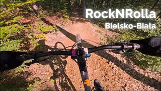
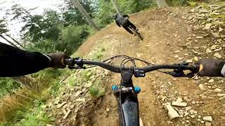
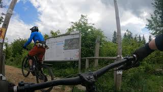
Najdłuższa i najbardziej urozmaicona trasa w kompleksie. Zaczyna się przy górnej stacji kolei gondolowej na Szyndzielni i zjeżdża na Przełęcz Sipa (Kozia) i dalej prowadzi krótkim podjazdem do schroniska na Koziej Górze (stąd można wybrać jedną z pięciu innych tras i zjechać dalej, aż na Błonia lub do Cygańskiego Lasu). Trasa ta w górnej części posiada spore i czasem dosyć strome bandy a w środkowej i dolnej sporo miejsc pozwalających „polatać” (wszystkie da się też przejechać bez odrywania od ziemi). Na trasie są także trzy punkty widokowe, pierwszy pozwala zobaczyć Kotlinę Żywiecką, drugi Bielsko, zaś z trzeciego widać zbocza Magurki a czasami na horyzoncie Tatry.

żródło:https://endurotrails.pl/trasy/trasy-niebieskie/rocknrolla

Bike Park

Recent Activity on Trail

Past Week
  • 6 rides
  • 42.0 km average
6 Months
  • 56 rides
  • 32.1 km avg distance
All
  • 724 rides
  • Last: Jun 23, 2026
c1c2c3c4
January
February
March
April
May
June
July
August
September
October
November
December
update trails status or condition

ROCKnRolla Trail Reports

statusdatedescription
Jun 9, 2026 @ 9:57am (Europe/Warsaw)
Jun 9, 2026
Trasa już nie jest flow. Ostatni remont był za Gierka. Bardzo niebezpieczne bandy pełne luźnych kamieni. Bywają też ogromne kamienie na...
Apr 21, 2026 @ 9:41pm (Europe/Warsaw)
Apr 21, 2026
Przeważnie sucho może zdarzyć się droga lekko wilgotna
Sep 26, 2025 @ 5:07pm (Europe/Warsaw)
Sep 26, 2025
nic, co by przeszkadzało w jeździe. kilka świeżych gałęzi i trochę liści. taka pora roku. niestety znowu pada.
Sep 26, 2025 @ 12:06pm (Europe/Bratislava)
Sep 26, 2025
Sep 22, 2025 @ 2:57pm (Europe/Warsaw)
Sep 22, 2025
Świeżo przedmuchana przez chłopaków
more »
Status:
on Jun 9, 2026
Dry
Avg: 4.58 (42 votes)
Your vote: 0

view (10,962)
close
3D
Trail Conditions
  • Unknown
  • Snow Groomed
  • Snow Packed
  • Snow Covered
  • Snow Cover Partial
  • Freeze/thaw Cycle
  • Icy
  • Prevalent Mud
  • Wet
  • Variable
  • Ideal
  • Dry
  • Very Dry
Trail Flow (Ridden Direction)
Trailforks scans users ridelogs to determine the most popular direction each trail is ridden. A good flowing trail network will have most trails flowing in a single direction according to their intension.
The colour categories are based on what percentage of riders are riding a trail in its intended direction.
  • > 96%
  • > 90%
  • > 80%
  • > 70%
  • > 50%
  • < 50%
  • bi-directional trail
  • no data
Trail Last Ridden
Trailforks scans ridelogs to determine the last time a trail was ridden.
  • < 2 days
  • < 1 week
  • < 2 weeks
  • < 1 month
  • < 6 months
  • > 6 months
Trail Ridden Direction
The intended direction a trail should be ridden.
  • Downhill Only
  • Downhill Primary
  • Both Directions
  • Uphill Primary
  • Uphill Only
  • One Direction
Contribute Details
Colors indicate trail is missing specified detail.
  • Description
  • Photos
  • Description & Photos
  • Videos
Trail Popularity ?
Trailforks scans ridelogs to determine which trails are ridden the most in the last 9 months. Trails are compared with nearby trails in the same city region with a possible 25 colour shades. Think of this as a heatmap, more rides = more kinetic energy = warmer colors.
  • most popular
  • popular
  • less popular
  • not popular
ATV/ORV/OHV Filter
Max Vehicle Width
inches
US Cell Coverage
Legend
cell carrier legend

Radar Time
Activity Recordings
Trailforks uses anonymized public activity data. ?
Activity Recordings
Trailforks uses anonymized public activity data. ?
Personal Heatmap
Activity Types
all / none
Options
2
Date range month
Winter Trails
Warning A routing network for winter maps does not exist. Selecting trails using the winter trails layer has been disabled.
Missing Trails
Most Popular
Least Popular
Trails are colored based on popularity. The more popular a trail is, the more red. Less popular trails trend towards green.
Jump Magnitude Heatmap
Heatmap of where riders jump on trails. Zoom in to see individual jumps, click circles to view jump details.
BC Backroad Status

Service Road Atlas is a free to use, community-driven service for viewing and creating reports on the numerous back-country service roads around B.C. and Alberta.

map legend
Slope Aspect
Direction the slope faces
Flat N NE E SE S SW W NW
Trails Deemphasized
Trails are shown in grey.
disable
Only show trails with no bike usage.
Enable
Suggested Layers
Based on selected activity type

    Save the current map location and zoom level as your default home location whenever this page is loaded.

    Save
        Directions to rocknrolla trailhead (49.759820, 19.001480)

        Photos

        13 more »
        281 |
        Sep 9, 2019 @ 12:10pm
        Sep 9, 2019
        284 |
        Sep 28, 2018 @ 12:33am
        Sep 28, 2018
        208 |
        Nov 11, 2023 @ 1:09am
        Nov 11, 2023
        250 |
        Nov 11, 2023 @ 1:09am
        Nov 11, 2023

        Videos

        12 more »
        Rock N Rolla  |  Full run
        11:42 | 174 | Sep 8, 2024 , Bielsko-Biała
        Enduro Trails Bielsko-Biala - Rockandrolla...
        10:31 | 108 | Jul 16, 2024 , Bielsko-Biała
        Rock'n'Rolla - najdłuższa trasa w...
        13:57 | 79 | Jul 7, 2024 , Bielsko-Biała
        [Enduro Trails] RockNRolla
        12:18 | 868 | May 28, 2021 , Bielsko-Biała

        7 Reviews & Comments


        We hope you've been enjoying Trailforks!

        Create a FREE account to view trail comments and much more.

        • By damiantraczTF Pro & contributors
        • #126228 - 9,765 views

        Frequently Asked Questions About ROCKnRolla

        Where is ROCKnRolla located?
        ROCKnRolla is located in Enduro Trails Bielsko-Biała, Bielsko-Biała, Poland. It is part of the Enduro Trails Bielsko-Biała trail network. The trailhead is located at coordinates 49.75982, 19.00148.
        How hard is ROCKnRolla?
        ROCKnRolla is rated as Blue difficulty. The physical rating is Easy. The average grade is 7.808%. The climb difficulty is rated Green.
        What is the elevation gain for ROCKnRolla?
        ROCKnRolla has 55 m of elevation gain. The trail has 398 m of elevation descent. The elevation ranges from 611 m to 956 m.
        Is ROCKnRolla a point to point trail?
        Yes, ROCKnRolla is a point to point trail. The direction is Downhill Only. The trail type is machine groomed.

        Hit the Trail

        Open in App

        Get this trail on your phone instantly.
        open trail in app

        Download Trail

        Save to wishlist, Garmin & download.
        save the trail

        Find Related Routes

        Find routes and users activities that include this trail.
        find routes for this trail

        You must enter a description before submitting.