more stats
4.6 miles
Distance
734 ft
Climb
-654 ft
Descent
01:00:37
Avg time
80 ft
Altitude change
5,001 ft
Altitude min
5,280 ft
Altitude max
5,051 ft
Altitude start
5,131 ft
Altitude end
0.333%
Grade
-58.489%
Grade max
52.477%
Grade min
2 miles
Distance climb
2 miles
Distance down
2,869 ft
Distance flat
01:00:37
Avg time

Rocky Tops Details

  • Activities
    • Mountain Bike
    • E-Bike
    • Adaptive Bike
    • Winter Fat Bike
    • Hike
    • Trail Running
  • Riding Area
    Navajo Rocks
    Moab, Utah
  • Difficulty Rating
  • Voted Difficulty
    Blue (3 votes)
  • Local Popularity
    95 in Mountain Biking [+]
    • 85 in Trail Running
    • 80 in Hiking
  • Global Ranking
    #17575 in Mountain Biking [+]
    • #2080 in Trail Running
    • #36965 in Hiking
  • Trail Type
    Singletrack
  • Bike Type
    AM, XC, Fat, Adaptive MTB
  • Direction
    One Direction
    Popular Direction Shown
  • Dogs Allowed
    Yes
  • eBike Allowed
  • Land Owner
    BLM

A mix of every kind of trail you can think of, rolled into one great ride.

Adaptive Bike Info
aMTB Black Rating: Advanced obstacles exist, some trail obstructions.

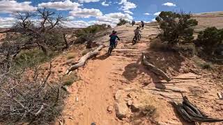
This is an adventure on an adaptive mountain bike. We took 2 bombers and did a lot of spotting for them on off cambered spots, rock crawls etc. Doable for a lower level spinal cord injury if you have good spotting, excellent line selection, great endurance and even better attitude. No points in the trail where you must get out of the bike or the bike is too wide.

Trail Supporters
Local Trail Association
Traditionally Indigenous Territory

Recent Activity on Trail

Past Week
  • 2 rides
  • 9 miles average
6 Months
  • 302 rides
  • 14 miles avg distance
All
  • 2,387 rides
  • Last: Jun 21, 2026
c1c2c3c4
January
February
March
April
May
June
July
August
September
October
November
December
update trails status or condition

Rocky Tops Trail Reports

statusdatedescription
Apr 29, 2026 @ 2:38pm (America/Denver)
Apr 29, 2026
Minor erosion (trail braiding, small ruts developings, brake bumps)
Apr 24, 2026 @ 11:20am (America/Denver)
Apr 24, 2026
Apr 4, 2026 @ 10:52am (America/Denver)
Apr 4, 2026
Great conditions. Some short sections with loose sand, but overall packed and tacky.
Mar 14, 2026 @ 9:47am (America/Denver)
Mar 14, 2026
Feb 14, 2026 @ 10:59am (America/Denver)
Feb 14, 2026
Sand is tacky
more »
Status:
on Apr 29, 2026
Avg: 4.13 (57 votes)
Your vote: 0

view (9,769)
close
3D
Trail Conditions
  • Unknown
  • Snow Groomed
  • Snow Packed
  • Snow Covered
  • Snow Cover Partial
  • Freeze/thaw Cycle
  • Icy
  • Prevalent Mud
  • Wet
  • Variable
  • Ideal
  • Dry
  • Very Dry
Trail Flow (Ridden Direction)
Trailforks scans users ridelogs to determine the most popular direction each trail is ridden. A good flowing trail network will have most trails flowing in a single direction according to their intension.
The colour categories are based on what percentage of riders are riding a trail in its intended direction.
  • > 96%
  • > 90%
  • > 80%
  • > 70%
  • > 50%
  • < 50%
  • bi-directional trail
  • no data
Trail Last Ridden
Trailforks scans ridelogs to determine the last time a trail was ridden.
  • < 2 days
  • < 1 week
  • < 2 weeks
  • < 1 month
  • < 6 months
  • > 6 months
Trail Ridden Direction
The intended direction a trail should be ridden.
  • Downhill Only
  • Downhill Primary
  • Both Directions
  • Uphill Primary
  • Uphill Only
  • One Direction
Contribute Details
Colors indicate trail is missing specified detail.
  • Description
  • Photos
  • Description & Photos
  • Videos
Trail Popularity ?
Trailforks scans ridelogs to determine which trails are ridden the most in the last 9 months. Trails are compared with nearby trails in the same city region with a possible 25 colour shades. Think of this as a heatmap, more rides = more kinetic energy = warmer colors.
  • most popular
  • popular
  • less popular
  • not popular
ATV/ORV/OHV Filter
Max Vehicle Width
inches
US Cell Coverage
Legend
cell carrier legend

Radar Time
Activity Recordings
Trailforks uses anonymized public activity data. ?
Activity Recordings
Trailforks uses anonymized public activity data. ?
Personal Heatmap
Activity Types
all / none
Options
2
Date range month
Winter Trails
Warning A routing network for winter maps does not exist. Selecting trails using the winter trails layer has been disabled.
Missing Trails
Most Popular
Least Popular
Trails are colored based on popularity. The more popular a trail is, the more red. Less popular trails trend towards green.
Jump Magnitude Heatmap
Heatmap of where riders jump on trails. Zoom in to see individual jumps, click circles to view jump details.
BC Backroad Status

Service Road Atlas is a free to use, community-driven service for viewing and creating reports on the numerous back-country service roads around B.C. and Alberta.

map legend
Slope Aspect
Direction the slope faces
Flat N NE E SE S SW W NW
Trails Deemphasized
Trails are shown in grey.
disable
Only show trails with no bike usage.
Enable
Suggested Layers
Based on selected activity type

    Save the current map location and zoom level as your default home location whenever this page is loaded.

    Save
        Directions to rocky-tops trailhead (38.640300, -109.749240)

        Photos

        74 more »
        940 |
        Apr 2, 2017 @ 7:37pm
        Apr 2, 2017
        890 |
        May 12, 2016 @ 9:03am
        May 12, 2016
        23 |
        Nov 25, 2025 @ 9:56pm
        Nov 25, 2025
        36 |
        Nov 25, 2025 @ 9:56pm
        Nov 25, 2025

        Videos

        8 more »
        youtuber Why I Love Riding Bikes - Solo Ride on Navajo...
        37:22 | 727 | Oct 9, 2019 , Moab
        youtuber Navajo Rocks 5 Trail Tour (Moab, Utah)...
        15:00 | 1252 | May 10, 2018 , Moab
        Rocky Tops
        32:23 | 117 | Apr 18, 2025 , Moab
        8 year old leading Rocky Tops at Navajo Rocks 1
        4:12 | 177 | Apr 21, 2024 , Moab

        Routes with this trail

        3.4 17 miles 1,596 ft 8 Loop
        All of Navajo Rocks goodness in the correct (Clockwise) direction. Sometimes referred to as "Chaco Loop".
        12 miles 1,060 ft 6
        Roam Retreat @ Moab Day 1: Navajo Rocks Wide variety of trails and great views. Good mix of dirt and...
        2.5 28 miles 2,215 ft 7 Loop
        Great Loop recommended by Larry the Legend.

        7 Reviews & Comments


        We hope you've been enjoying Trailforks!

        Create a FREE account to view trail comments and much more.

        Nearby Trails

        • By toddTF Pro Trailforks & contributors
        • #9043 - 9,042 views

        Frequently Asked Questions About Rocky Tops

        Where is Rocky Tops located?
        Rocky Tops is located in Navajo Rocks, Moab, Utah, United States. It is part of the Navajo Rocks trail network. The trailhead is located at coordinates 38.6403, -109.74924.
        How hard is Rocky Tops?
        Rocky Tops is rated as Blue difficulty. The average grade is 0.333%.
        What is the elevation gain for Rocky Tops?
        Rocky Tops has 734 ft of elevation gain. The trail has 654 ft of elevation descent. The elevation ranges from 5,001 ft to 5,280 ft.
        Is Rocky Tops a point to point trail?
        Yes, Rocky Tops is a point to point trail. The direction is One Direction. The trail type is singletrack.

        Hit the Trail

        Open in App

        Get this trail on your phone instantly.
        open trail in app

        Download Trail

        Save to wishlist, Garmin & download.
        save the trail

        Find Related Routes

        Find routes and users activities that include this trail.
        find routes for this trail

        You must enter a description before submitting.