more stats
8.5 miles
Distance
489 ft
Climb
-517 ft
Descent
01:35:02
Avg time
-28 ft
Altitude change
5,603 ft
Altitude min
5,886 ft
Altitude max
5,871 ft
Altitude start
5,843 ft
Altitude end
-0.1%
Grade
-13.6%
Grade max
18.7%
Grade min
3 miles
Distance climb
3 miles
Distance down
2 miles
Distance flat
01:35:02
Avg time

Rodeo Details

  • Activities
    • Mountain Bike
    • E-Bike
    • Winter Fat Bike
    • Hike
    • Trail Running
  • Riding Area
    Horsethief
    Moab, Utah
  • Difficulty Rating
  • Voted Difficulty
    Blue (1 vote)
  • Local Popularity
    90 in Mountain Biking [+]
    • 55 in Trail Running
    • 85 in Hiking
  • Global Ranking
    #3406 in Mountain Biking [+]
    • #295 in Trail Running
    • #1125 in Hiking
  • Hiking SAC Scale
    T1 Hiking
  • Trail Type
    Singletrack
  • Bike Type
    AM, XC, Fat
  • Climb Difficulty
    Blue
  • Physical Rating
    Moderate
  • Dogs Allowed
    Yes
  • eBike Allowed
    Yes up to Class 1
  • Year Opened
    2017
  • Land Owner
    BLM

NOTICE: Directional trail, ride clockwise.
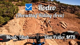
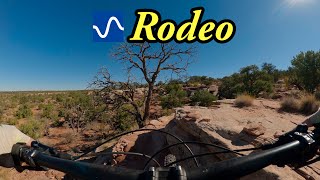
Rodeo is 8.2 miles of trail that twists and turns through pinion and juniper trees, up and down rock ledges with long views looking out to the Henry Mountains.
Note that there are no signed bail out points or intersecting trails on Rodeo until you are near the Horsethief Campground. Be prepared for over 8 miles of trail.

Access Info

Start from the southern Rodeo entrance that can be found on the Chisholm Trail.

Disclaimer

DIRECTIONAL - RIDE CLOCKWISE

Trail Supporters
Local Trail Association
Traditionally Indigenous Territory

Recent Activity on Trail

Past Week
  • 1 rides
  • 11 miles average
6 Months
  • 123 rides
  • 14 miles avg distance
All
  • 1,189 rides
  • Last: Jun 13, 2026
c1c2c3c4
January
February
March
April
May
June
July
August
September
October
November
December
Status:
on Apr 4, 2026
Ideal
Avg: 4.1 (50 votes)
Your vote: 0

view (3,770)
close
3D
Trail Conditions
  • Unknown
  • Snow Groomed
  • Snow Packed
  • Snow Covered
  • Snow Cover Partial
  • Freeze/thaw Cycle
  • Icy
  • Prevalent Mud
  • Wet
  • Variable
  • Ideal
  • Dry
  • Very Dry
Trail Flow (Ridden Direction)
Trailforks scans users ridelogs to determine the most popular direction each trail is ridden. A good flowing trail network will have most trails flowing in a single direction according to their intension.
The colour categories are based on what percentage of riders are riding a trail in its intended direction.
  • > 96%
  • > 90%
  • > 80%
  • > 70%
  • > 50%
  • < 50%
  • bi-directional trail
  • no data
Trail Last Ridden
Trailforks scans ridelogs to determine the last time a trail was ridden.
  • < 2 days
  • < 1 week
  • < 2 weeks
  • < 1 month
  • < 6 months
  • > 6 months
Trail Ridden Direction
The intended direction a trail should be ridden.
  • Downhill Only
  • Downhill Primary
  • Both Directions
  • Uphill Primary
  • Uphill Only
  • One Direction
Contribute Details
Colors indicate trail is missing specified detail.
  • Description
  • Photos
  • Description & Photos
  • Videos
Trail Popularity ?
Trailforks scans ridelogs to determine which trails are ridden the most in the last 9 months. Trails are compared with nearby trails in the same city region with a possible 25 colour shades. Think of this as a heatmap, more rides = more kinetic energy = warmer colors.
  • most popular
  • popular
  • less popular
  • not popular
ATV/ORV/OHV Filter
Max Vehicle Width
inches
US Cell Coverage
Legend
cell carrier legend

Radar Time
Activity Recordings
Trailforks uses anonymized public activity data. ?
Activity Recordings
Trailforks uses anonymized public activity data. ?
Personal Heatmap
Activity Types
all / none
Options
2
Date range month
Winter Trails
Warning A routing network for winter maps does not exist. Selecting trails using the winter trails layer has been disabled.
Missing Trails
Most Popular
Least Popular
Trails are colored based on popularity. The more popular a trail is, the more red. Less popular trails trend towards green.
Jump Magnitude Heatmap
Heatmap of where riders jump on trails. Zoom in to see individual jumps, click circles to view jump details.
BC Backroad Status

Service Road Atlas is a free to use, community-driven service for viewing and creating reports on the numerous back-country service roads around B.C. and Alberta.

map legend
Slope Aspect
Direction the slope faces
Flat N NE E SE S SW W NW
Trails Deemphasized
Trails are shown in grey.
disable
Only show trails with no bike usage.
Enable
Suggested Layers
Based on selected activity type

    Save the current map location and zoom level as your default home location whenever this page is loaded.

    Save
        Directions to rodeo-90347 trailhead (38.581850, -109.804190)

        Photos

        48 more »
        61 |
        Oct 23, 2025 @ 5:34pm
        Oct 23, 2025
        61 |
        Oct 23, 2025 @ 5:33pm
        Oct 23, 2025
        199 |
        May 13, 2023 @ 9:10pm
        May 13, 2023
        172 |
        May 13, 2023 @ 9:10pm
        May 13, 2023

        Videos

        3 more »
        Rodeo at the Horsethief Riding Area in Moab, Utah
        1:11:18 | 83 | Jan 24, 2026 , Moab
        youtuber Rodeo
        13:30 | 340 | Nov 22, 2024 , Moab
        Rodeo Trail
        2461 | May 25, 2017 , Moab

        Routes with this trail

        4.0 23 miles 1,733 ft 5
        GU Getaway Day 2 Full
        100 miles 9,372 ft 21 Loop

        23 Reviews & Comments


        We hope you've been enjoying Trailforks!

        Create a FREE account to view trail comments and much more.

        • By toddTF Pro Trailforks & contributors
        • #90347 - 12,635 views

        Frequently Asked Questions About Rodeo

        Where is Rodeo located?
        Rodeo is located in Horsethief, Moab, Utah, United States. It is part of the Horsethief trail network. The trailhead is located at coordinates 38.58185, -109.80419.
        How hard is Rodeo?
        Rodeo is rated as Blue difficulty. The physical rating is Moderate. The average grade is 0.1%. The climb difficulty is rated Blue.
        What is the elevation gain for Rodeo?
        Rodeo has 489 ft of elevation gain. The trail has 517 ft of elevation descent. The elevation ranges from 5,603 ft to 5,886 ft.
        How long is Rodeo?
        Rodeo is 8.5 miles long. The trail type is singletrack.

        Hit the Trail

        Open in App

        Get this trail on your phone instantly.
        open trail in app

        Download Trail

        Save to wishlist, Garmin & download.
        save the trail

        Find Related Routes

        Find routes and users activities that include this trail.
        find routes for this trail

        You must enter a description before submitting.