more stats
4,793 ft
Distance
34 ft
Climb
-273 ft
Descent
00:05:40
Avg time
-241 ft
Altitude change
1,772 ft
Altitude min
2,020 ft
Altitude max
2,013 ft
Altitude start
1,772 ft
Altitude end
-5.019%
Grade
-18.853%
Grade max
9.656%
Grade min
819 ft
Distance climb
3,974 ft
Distance down
00:05:40
Avg time

Roller Coaster Details

  • Activities
    • Mountain Bike
    • E-Bike
    • Hike
    • Trail Running
  • Riding Area
    Three Blind Mice
    Penticton, British Columbia
  • Difficulty Rating
  • Local Popularity
    90 in Mountain Biking [+]
    • 75 in E-Biking
    • 85 in Trail Running
    • 90 in Hiking
  • Global Ranking
    #46762 in Mountain Biking [+]
    • #49364 in E-Biking
    • #75051 in Trail Running
    • #54911 in Hiking
  • Trail Type
    Singletrack
  • Bike Type
    AM, XC
  • Direction
    Downhill Primary
    Popular Direction Shown
  • Dogs Allowed
    Yes
  • eBike Allowed
    Yes up to Class 1
  • TTFs on Trail
    Berm, Jump

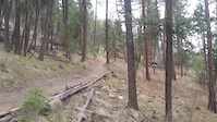
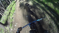
Best way to end a ride in the Mice. Open up the throttle and coast it out. Truely one of the few actual trails with flow in the Mice. Has the floatie step-down, step-up dubbed Compression Redemption and then it ties into Tsweet Tsue.
It also has a few little poppers along the way.

Access Info

From where-ever you are descending, if you cross Roller Coaster, your natural instinct will be to connect to it.

Local Trail Association

Recent Activity on Trail

Past Week
  • 1 rides
  • 11 miles average
6 Months
  • 40 rides
  • 12 miles avg distance
All
  • 664 rides
  • Last: Jun 18, 2026
c1c2c3c4
January
February
March
April
May
June
July
August
September
October
November
December
Status:
on Apr 21, 2026
Dry
Avg: 3.87 (17 votes)
Your vote: 0

view (3,592)
close
3D
Trail Conditions
  • Unknown
  • Snow Groomed
  • Snow Packed
  • Snow Covered
  • Snow Cover Partial
  • Freeze/thaw Cycle
  • Icy
  • Prevalent Mud
  • Wet
  • Variable
  • Ideal
  • Dry
  • Very Dry
Trail Flow (Ridden Direction)
Trailforks scans users ridelogs to determine the most popular direction each trail is ridden. A good flowing trail network will have most trails flowing in a single direction according to their intension.
The colour categories are based on what percentage of riders are riding a trail in its intended direction.
  • > 96%
  • > 90%
  • > 80%
  • > 70%
  • > 50%
  • < 50%
  • bi-directional trail
  • no data
Trail Last Ridden
Trailforks scans ridelogs to determine the last time a trail was ridden.
  • < 2 days
  • < 1 week
  • < 2 weeks
  • < 1 month
  • < 6 months
  • > 6 months
Trail Ridden Direction
The intended direction a trail should be ridden.
  • Downhill Only
  • Downhill Primary
  • Both Directions
  • Uphill Primary
  • Uphill Only
  • One Direction
Contribute Details
Colors indicate trail is missing specified detail.
  • Description
  • Photos
  • Description & Photos
  • Videos
Trail Popularity ?
Trailforks scans ridelogs to determine which trails are ridden the most in the last 9 months. Trails are compared with nearby trails in the same city region with a possible 25 colour shades. Think of this as a heatmap, more rides = more kinetic energy = warmer colors.
  • most popular
  • popular
  • less popular
  • not popular
ATV/ORV/OHV Filter
Max Vehicle Width
inches
US Cell Coverage
Legend
cell carrier legend

Radar Time
Activity Recordings
Trailforks uses anonymized public activity data. ?
Activity Recordings
Trailforks uses anonymized public activity data. ?
Personal Heatmap
Activity Types
all / none
Options
2
Date range month
Winter Trails
Warning A routing network for winter maps does not exist. Selecting trails using the winter trails layer has been disabled.
Missing Trails
Most Popular
Least Popular
Trails are colored based on popularity. The more popular a trail is, the more red. Less popular trails trend towards green.
Jump Magnitude Heatmap
Heatmap of where riders jump on trails. Zoom in to see individual jumps, click circles to view jump details.
BC Backroad Status

Service Road Atlas is a free to use, community-driven service for viewing and creating reports on the numerous back-country service roads around B.C. and Alberta.

map legend
Slope Aspect
Direction the slope faces
Flat N NE E SE S SW W NW
Trails Deemphasized
Trails are shown in grey.
disable
Only show trails with no bike usage.
Enable
Suggested Layers
Based on selected activity type

    Save the current map location and zoom level as your default home location whenever this page is loaded.

    Save
        Directions to roller-coaster-19030 trailhead (49.553140, -119.558760)

        Photos

        8 more »
        122 |
        Jul 19, 2020 @ 12:43pm
        Jul 19, 2020
        400 |
        Jan 13, 2016 @ 11:06am
        Jan 13, 2016
        76 |
        Jul 19, 2020 @ 12:44pm
        Jul 19, 2020
        62 |
        Jul 19, 2020 @ 12:43pm
        Jul 19, 2020

        Videos

        11 more »
        youtuber Compression Session Freedom Youth Crew
        3:00 | 404 | Jun 12, 2018 , Penticton
        Local Trail
        0:16 | 331 | Apr 3, 2014 , Penticton
        crazy trail
        4:37 | 1073 | May 20, 2011 , Penticton
        crazy ass trail
        2:56 | 217 | May 2, 2011 , Penticton

        Routes with this trail

        Lookout Loop Featured
        3.7 8 miles 1,154 ft 13 Loop
        A good intro to the Three Blind Mice trails. Easy up and back. Just follow the round blue signs that say...
        4.0 5 miles 202 ft 11 Shuttled
        So, you find yourself at the top of 3 Blind Mice, you may ask yourself the following questions. What's the...
        9 miles 1,666 ft 11
        One of our best and most well-ridden loops. Be sure to catch your breath and take in the view before you...

        Trail Products

        Reviews / Comments

        No reviews yet, be the first to write a review or ask a question.
        Use trail reports to comment on trail conditions.


        We hope you've been enjoying Trailforks!

        Create a FREE account to view trail comments and much more.

        • By smokeTF Pro Simpcw & contributors
        • #19030 - 4,659 views

        Frequently Asked Questions About Roller Coaster

        Where is Roller Coaster located?
        Roller Coaster is located in Three Blind Mice, Penticton, British Columbia, Canada. It is part of the Three Blind Mice trail network. The trailhead is located at coordinates 49.55314, -119.55876.
        How hard is Roller Coaster?
        Roller Coaster is rated as Blue difficulty. The average grade is 5.019%.
        What is the elevation gain for Roller Coaster?
        Roller Coaster has 34 ft of elevation gain. The trail has 273 ft of elevation descent. The elevation ranges from 1,772 ft to 2,020 ft.
        Is Roller Coaster a point to point trail?
        Roller Coaster is not a point to point trail. The direction is Downhill Primary. The trail type is singletrack.

        Hit the Trail

        Open in App

        Get this trail on your phone instantly.
        open trail in app

        Download Trail

        Save to wishlist, Garmin & download.
        save the trail

        Find Related Routes

        Find routes and users activities that include this trail.
        find routes for this trail

        You must enter a description before submitting.