more stats
1.3 miles
Distance
108 ft
Climb
-129 ft
Descent
00:13:20
Avg time
-21 ft
Altitude change
397 ft
Altitude min
450 ft
Altitude max
419 ft
Altitude start
397 ft
Altitude end
-0.3%
Grade
-15.3%
Grade max
25%
Grade min
2,067 ft
Distance climb
3,366 ft
Distance down
1,358 ft
Distance flat
00:13:20
Avg time

RollerFlowster Details

  • Activities
    • Mountain Bike
    • E-Bike
    • Winter Fat Bike
    • Hike
    • Trail Running
  • Riding Area
    Don Valley
    Toronto, Ontario
  • AKA
    Smith's Edge
  • Difficulty Rating
  • Voted Difficulty
    Double Black Diamond (9 votes)
  • Local Popularity
    100 in Mountain Biking [+]
    • 100 in E-Biking
    • 90 in Trail Running
    • 95 in Hiking
  • Global Ranking
    #306 in Mountain Biking [+]
    • #8290 in E-Biking
    • #150 in Trail Running
    • #781 in Hiking
  • Trail Type
    Singletrack
  • Bike Type
    AM, XC, Fat
  • Direction
    One Direction
    Popular Direction Shown
  • Climb Difficulty
    Black Diamond
  • Physical Rating
    Hard
  • Trail Visibility
    Always easy to follow
  • Season
    April - Dec
  • eBike Allowed
    Yes up to Class 1
  • TTFs on Trail
    Berm, Bridge, Drop, Jump, Gap Jump, Ladder Bridge, Log Ride, Roller Coaster, Wallride, Other
  • Year Opened
    2014
  • Land Owner

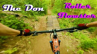
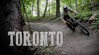
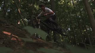
Flowy berms, a few small jumps, one medium jump with gap. Jumps have go-arounds. Narrow bench cut for some of the sections. Steep Climbs, Caution on rollers as puddles may accumulate at G-out and you enter them blind. After passing the Sunnybrook Hospital parking lot, the trail drops into a medium jump line. Followed by a mellow flat section that drops into a big flowy turn / straightaway section. Finishes with a 4-option DH exit. All options are steep and challenging.

This trail is unsanctioned.

Disclaimer

Due to elevated exposure and several blind features, trail "difficulty rating" has been bumped up one level above technical difficulty.

Recent Activity on Trail

Past Week
  • 29 rides
  • 13 miles average
6 Months
  • 198 rides
  • 14 miles avg distance
All
  • 3,893 rides
  • Last: Jun 20, 2026
c1c2c3c4
January
February
March
April
May
June
July
August
September
October
November
December
update trails status or condition

RollerFlowster Trail Reports

statusdatedescription
May 26, 2026 @ 8:25pm (America/Toronto)
May 26, 2026
Great
May 9, 2026 @ 7:07am (America/Toronto)
May 9, 2026
May 1, 2026 @ 2:18pm (America/Toronto)
May 1, 2026
Kudos to the trail fairies - amazing bridge work!!
Apr 21, 2026 @ 5:33pm (America/Toronto)
Apr 21, 2026
The trail fairies have outdone themselves this time. The new bridge is a work of art
Apr 4, 2026 @ 10:34am (America/Toronto)
Apr 4, 2026
Mud slide on first set of switchbacks. Trail between second and third switchbacks is gone. Large pile of mud covering little bridge between first...
more »
Status:
on May 26, 2026
Ideal
Avg: 4.45 (61 votes)
Your vote: 0

view (19,380)
close
3D
Trail Conditions
  • Unknown
  • Snow Groomed
  • Snow Packed
  • Snow Covered
  • Snow Cover Partial
  • Freeze/thaw Cycle
  • Icy
  • Prevalent Mud
  • Wet
  • Variable
  • Ideal
  • Dry
  • Very Dry
Trail Flow (Ridden Direction)
Trailforks scans users ridelogs to determine the most popular direction each trail is ridden. A good flowing trail network will have most trails flowing in a single direction according to their intension.
The colour categories are based on what percentage of riders are riding a trail in its intended direction.
  • > 96%
  • > 90%
  • > 80%
  • > 70%
  • > 50%
  • < 50%
  • bi-directional trail
  • no data
Trail Last Ridden
Trailforks scans ridelogs to determine the last time a trail was ridden.
  • < 2 days
  • < 1 week
  • < 2 weeks
  • < 1 month
  • < 6 months
  • > 6 months
Trail Ridden Direction
The intended direction a trail should be ridden.
  • Downhill Only
  • Downhill Primary
  • Both Directions
  • Uphill Primary
  • Uphill Only
  • One Direction
Contribute Details
Colors indicate trail is missing specified detail.
  • Description
  • Photos
  • Description & Photos
  • Videos
Trail Popularity ?
Trailforks scans ridelogs to determine which trails are ridden the most in the last 9 months. Trails are compared with nearby trails in the same city region with a possible 25 colour shades. Think of this as a heatmap, more rides = more kinetic energy = warmer colors.
  • most popular
  • popular
  • less popular
  • not popular
ATV/ORV/OHV Filter
Max Vehicle Width
inches
US Cell Coverage
Legend
cell carrier legend

Radar Time
Activity Recordings
Trailforks uses anonymized public activity data. ?
Activity Recordings
Trailforks uses anonymized public activity data. ?
Personal Heatmap
Activity Types
all / none
Options
2
Date range month
Winter Trails
Warning A routing network for winter maps does not exist. Selecting trails using the winter trails layer has been disabled.
Missing Trails
Most Popular
Least Popular
Trails are colored based on popularity. The more popular a trail is, the more red. Less popular trails trend towards green.
Jump Magnitude Heatmap
Heatmap of where riders jump on trails. Zoom in to see individual jumps, click circles to view jump details.
BC Backroad Status

Service Road Atlas is a free to use, community-driven service for viewing and creating reports on the numerous back-country service roads around B.C. and Alberta.

map legend
Slope Aspect
Direction the slope faces
Flat N NE E SE S SW W NW
Trails Deemphasized
Trails are shown in grey.
disable
Only show trails with no bike usage.
Enable
Suggested Layers
Based on selected activity type

    Save the current map location and zoom level as your default home location whenever this page is loaded.

    Save
        Directions to rollerflowster trailhead (43.718900, -79.378310)

        Photos

        117 more »
        557 |
        Oct 25, 2020 @ 6:39pm
        Oct 25, 2020
        3,001 |
        Jun 5, 2018 @ 4:48pm
        Jun 5, 2018
        34 |
        May 23, 2026 @ 1:09pm
        May 23, 2026
        434 |
        Nov 8, 2021 @ 2:44pm
        Nov 8, 2021

        Videos

        14 more »
        youtuber Don Valley Mountain Bike Trails:  Roller...
        3:42 | 3255 | May 23, 2020 , Toronto
        youtuber MTB Trail in Toronto - Roller Flowster - Ride...
        0:50 | 5417 | May 27, 2018 , Toronto
        Roller Flowster Edit // Don Valley
        0:48 | 97 | Aug 11, 2025 , Toronto
        A double black diamond trail in downtown Toronto
        9:30 | 158 | Nov 1, 2024 , Toronto

        Trail Lists

        Routes with this trail

        5.0 59 miles 5,018 ft 111 Loop
        100k loop through the greater Valley, the route has almost no repeat sections. Consists mostly of...
        4.0 24 miles 2,002 ft 50 Loop
        A route linking together the all the hardest trails throughout the Don Valley. This is a physically...
        3.9 16 miles 1,371 ft 56
        Big loop in the Don featuring a good mix of the standards and the more difficult trails at the north end.

        35 Reviews & Comments


        We hope you've been enjoying Trailforks!

        Create a FREE account to view trail comments and much more.

        • #38795 - 30,360 views

        Frequently Asked Questions About RollerFlowster

        Where is RollerFlowster located?
        RollerFlowster is located in Don Valley, Toronto, Ontario, Canada. It is part of the Don Valley trail network. The trailhead is located at coordinates 43.7189, -79.37831.
        How hard is RollerFlowster?
        RollerFlowster is rated as Double Black Diamond difficulty. The physical rating is Hard. The average grade is 0.3%. The climb difficulty is rated Black Diamond.
        What is the elevation gain for RollerFlowster?
        RollerFlowster has 33 m of elevation gain. The trail has 39 m of elevation descent. The elevation ranges from 121 m to 137 m.
        Is RollerFlowster a point to point trail?
        Yes, RollerFlowster is a point to point trail. The direction is One Direction. The trail type is singletrack.

        Hit the Trail

        Open in App

        Get this trail on your phone instantly.
        open trail in app

        Download Trail

        Save to wishlist, Garmin & download.
        save the trail

        Find Related Routes

        Find routes and users activities that include this trail.
        find routes for this trail

        You must enter a description before submitting.