more stats
3.3 miles
Distance
92 ft
Climb
-1,484 ft
Descent
00:25:44
Avg time
-1,392 ft
Altitude change
1,640 ft
Altitude min
3,063 ft
Altitude max
3,031 ft
Altitude start
1,640 ft
Altitude end
-8%
Grade
-63%
Grade max
29.5%
Grade min
2,267 ft
Distance climb
3 miles
Distance down
794 ft
Distance flat
00:25:44
Avg time

Roques Pelades Details

  • Activities
    • Mountain Bike
    • E-Bike
  • Riding Area
  • Difficulty Rating
  • Local Popularity
    100 in Mountain Biking [+]
    • 100 in E-Biking
  • Global Ranking
    #897 in Mountain Biking [+]
    • #560 in E-Biking
  • Trail Type
    Singletrack
  • Bike Type
    AM, XC
  • Direction
    Downhill Primary
    Popular Direction Shown
  • Climb Difficulty
    Blue
  • Physical Rating
    Moderate
  • Trail Visibility
    Always easy to follow
  • Dogs Allowed
    Yes
  • eBike Allowed
    Yes up to Class 1
  • Land Owner
    Associació Lo Podall

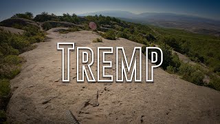
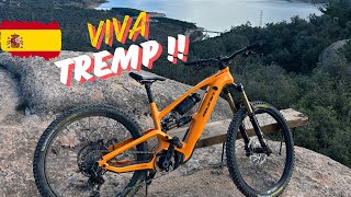
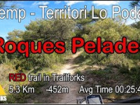
Sender que segueix el carener de Castilló fins a arribar a una zona rocosa de formes curioses anomenada Roques Pelades. Terreny variat amb molt bones vistes. En la part baixa ens endinsem en bosc de pi i alzines. Trams ràpids i divertits.En dies humits no fa fang.
ESP: Trail que sigue la carena de Castilló hasta llegar a una zona rocosa de formas curiosas llamada Roques Pelades. Terreno variado con buenas vistas. En su parte baja nos adentramos en bosque de pino i encinas. Tramos ràpidos y divertidos. En dias de humedad no hace barro.

Local Trail Association

Recent Activity on Trail

Past Week
  • 1 rides
  • 15 miles average
6 Months
  • 72 rides
  • 22 miles avg distance
All
  • 466 rides
  • Last: Jun 17, 2026
c1c2c3c4
January
February
March
April
May
June
July
August
September
October
November
December
Status:
on May 18, 2026
Ideal
Avg: 4.7 (55 votes)
Your vote: 0

view (3,190)
close
3D
Trail Conditions
  • Unknown
  • Snow Groomed
  • Snow Packed
  • Snow Covered
  • Snow Cover Partial
  • Freeze/thaw Cycle
  • Icy
  • Prevalent Mud
  • Wet
  • Variable
  • Ideal
  • Dry
  • Very Dry
Trail Flow (Ridden Direction)
Trailforks scans users ridelogs to determine the most popular direction each trail is ridden. A good flowing trail network will have most trails flowing in a single direction according to their intension.
The colour categories are based on what percentage of riders are riding a trail in its intended direction.
  • > 96%
  • > 90%
  • > 80%
  • > 70%
  • > 50%
  • < 50%
  • bi-directional trail
  • no data
Trail Last Ridden
Trailforks scans ridelogs to determine the last time a trail was ridden.
  • < 2 days
  • < 1 week
  • < 2 weeks
  • < 1 month
  • < 6 months
  • > 6 months
Trail Ridden Direction
The intended direction a trail should be ridden.
  • Downhill Only
  • Downhill Primary
  • Both Directions
  • Uphill Primary
  • Uphill Only
  • One Direction
Contribute Details
Colors indicate trail is missing specified detail.
  • Description
  • Photos
  • Description & Photos
  • Videos
Trail Popularity ?
Trailforks scans ridelogs to determine which trails are ridden the most in the last 9 months. Trails are compared with nearby trails in the same city region with a possible 25 colour shades. Think of this as a heatmap, more rides = more kinetic energy = warmer colors.
  • most popular
  • popular
  • less popular
  • not popular
ATV/ORV/OHV Filter
Max Vehicle Width
inches
US Cell Coverage
Legend
cell carrier legend

Radar Time
Activity Recordings
Trailforks uses anonymized public activity data. ?
Activity Recordings
Trailforks uses anonymized public activity data. ?
Personal Heatmap
Activity Types
all / none
Options
2
Date range month
Winter Trails
Warning A routing network for winter maps does not exist. Selecting trails using the winter trails layer has been disabled.
Missing Trails
Most Popular
Least Popular
Trails are colored based on popularity. The more popular a trail is, the more red. Less popular trails trend towards green.
Jump Magnitude Heatmap
Heatmap of where riders jump on trails. Zoom in to see individual jumps, click circles to view jump details.
BC Backroad Status

Service Road Atlas is a free to use, community-driven service for viewing and creating reports on the numerous back-country service roads around B.C. and Alberta.

map legend
Slope Aspect
Direction the slope faces
Flat N NE E SE S SW W NW
Trails Deemphasized
Trails are shown in grey.
disable
Only show trails with no bike usage.
Enable
Suggested Layers
Based on selected activity type

    Save the current map location and zoom level as your default home location whenever this page is loaded.

    Save
        Directions to roques-pelades trailhead (42.212840, 0.892460)

        Photos

        55 more »
        95 |
        Apr 26, 2025 @ 7:53am
        Apr 26, 2025
        497 |
        Dec 9, 2020 @ 4:57am
        Dec 9, 2020
        18 |
        May 26, 2026 @ 3:49am
        May 26, 2026
        19 |
        May 26, 2026 @ 3:49am
        May 26, 2026

        Videos

        11 more »
        youtuber Tremp - Roques Pelades + Valkyries II |...
        8:18 | 453 | Oct 31, 2023 , Tremp
        Tremp Roques Pelades/Escorpins
        14:16 | 115 | Nov 18, 2024 , Tremp
        youtuber A disastrous beginning to my holiday in Tremp
        15:20 | 152 | Nov 4, 2024 , Tremp
        Roques Pelades - eBiciats
        15:03 | 147 | May 10, 2024 , Tremp

        Routes with this trail

        5.0 16 miles 2,441 ft 5 Loop
        Ruta cap a passant per altres trails interessants. ESP: Ruta que va a y que pasa por otros trails...
        5.0 16 miles 2,802 ft 14 Loop
        Ruta que ens porta al Trail dels . Passant per la font de Talarn, Baixada pel ZZ Top fins anar a buscar la...
        5.0 17 miles 2,618 ft 8 Loop
        Ruta moderada que enlaza algunos de los mejores senderos de la zona, , Valkyries2, ]. Estos combinan...

        18 Reviews & Comments


        We hope you've been enjoying Trailforks!

        Create a FREE account to view trail comments and much more.

        Frequently Asked Questions About Roques Pelades

        Where is Roques Pelades located?
        Roques Pelades is located in Territori Lo Podall Tremp, Tremp, Spain. It is part of the Territori Lo Podall Tremp trail network. The trailhead is located at coordinates 42.21284, 0.89246.
        How hard is Roques Pelades?
        Roques Pelades is rated as Red difficulty. The physical rating is Moderate. The average grade is 8%. The climb difficulty is rated Blue.
        What is the elevation gain for Roques Pelades?
        Roques Pelades has 28 m of elevation gain. The trail has 452 m of elevation descent. The elevation ranges from 500 m to 934 m.
        Is Roques Pelades a point to point trail?
        Roques Pelades is not a point to point trail. The direction is Downhill Primary. The trail type is singletrack.

        Hit the Trail

        Open in App

        Get this trail on your phone instantly.
        open trail in app

        Download Trail

        Save to wishlist, Garmin & download.
        save the trail

        Find Related Routes

        Find routes and users activities that include this trail.
        find routes for this trail

        You must enter a description before submitting.