more stats
2.2 miles
Distance
5 ft
Climb
-1,718 ft
Descent
00:20:34
Avg time
-1,713 ft
Altitude change
3,964 ft
Altitude min
5,678 ft
Altitude max
5,677 ft
Altitude start
3,963 ft
Altitude end
-15%
Grade
-62.1%
Grade max
3.1%
Grade min
354 ft
Distance climb
2 miles
Distance down
20 ft
Distance flat
00:20:34
Avg time

Rumplestumpskin Details

  • Activities
    • Mountain Bike
  • Riding Area
    Fernie Alpine Resort
    Fernie, British Columbia
  • Difficulty Rating
  • Local Popularity
    90 in Mountain Biking
  • Global Ranking
    #44768 in Mountain Biking
  • Trail Type
    Singletrack
  • Bike Type
    DH
  • Dogs Allowed
    Yes
  • Land Owner

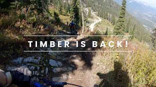
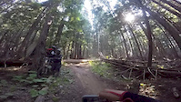
New in 2008 this quickly became a fan favorite Top to bottom on the Timber side, this wide trail provides a less aggressive option to get down. Using a network of old trails with a large new section, you will be able to follow a unique path all the way to base. Look out for a few steep sections!

Bike Park

Traditionally Indigenous Territory

Recent Activity on Trail

Past Week
  • 0 rides
  •  
6 Months
  • 0 rides
  •  
All
  • 87 rides
  • Last: Sep 7, 2025
c1c2c3c4
January
February
March
April
May
June
July
August
September
October
November
December
update trails status or condition

Rumplestumpskin Trail Reports

statusdatedescription
Sep 8, 2025 @ 2:23pm
Sep 8, 2025
Closed for the season - will re-open for Fernie Alpine Resort's summer operation in late June 2026.
Aug 31, 2025 @ 10:02am
Aug 31, 2025
Jul 6, 2025 @ 12:11pm
Jul 6, 2025
May 29, 2025 @ 11:26am
May 29, 2025
Sep 3, 2024 @ 9:43am
Sep 3, 2024
Closed for the season - will re-open for Fernie Alpine Resort's summer season in late June 2025
more »
Status:
on Sep 8, 2025
Ideal
Avg: 4.31 (10 votes)
Your vote: 0

view (1,123)
close
3D
Trail Conditions
  • Unknown
  • Snow Groomed
  • Snow Packed
  • Snow Covered
  • Snow Cover Partial
  • Freeze/thaw Cycle
  • Icy
  • Prevalent Mud
  • Wet
  • Variable
  • Ideal
  • Dry
  • Very Dry
Trail Flow (Ridden Direction)
Trailforks scans users ridelogs to determine the most popular direction each trail is ridden. A good flowing trail network will have most trails flowing in a single direction according to their intension.
The colour categories are based on what percentage of riders are riding a trail in its intended direction.
  • > 96%
  • > 90%
  • > 80%
  • > 70%
  • > 50%
  • < 50%
  • bi-directional trail
  • no data
Trail Last Ridden
Trailforks scans ridelogs to determine the last time a trail was ridden.
  • < 2 days
  • < 1 week
  • < 2 weeks
  • < 1 month
  • < 6 months
  • > 6 months
Trail Ridden Direction
The intended direction a trail should be ridden.
  • Downhill Only
  • Downhill Primary
  • Both Directions
  • Uphill Primary
  • Uphill Only
  • One Direction
Contribute Details
Colors indicate trail is missing specified detail.
  • Description
  • Photos
  • Description & Photos
  • Videos
Trail Popularity ?
Trailforks scans ridelogs to determine which trails are ridden the most in the last 9 months. Trails are compared with nearby trails in the same city region with a possible 25 colour shades. Think of this as a heatmap, more rides = more kinetic energy = warmer colors.
  • most popular
  • popular
  • less popular
  • not popular
ATV/ORV/OHV Filter
Max Vehicle Width
inches
US Cell Coverage
Legend
cell carrier legend

Radar Time
Activity Recordings
Trailforks uses anonymized public activity data. ?
Activity Recordings
Trailforks uses anonymized public activity data. ?
Personal Heatmap
Activity Types
all / none
Options
2
Date range month
Winter Trails
Warning A routing network for winter maps does not exist. Selecting trails using the winter trails layer has been disabled.
Missing Trails
Most Popular
Least Popular
Trails are colored based on popularity. The more popular a trail is, the more red. Less popular trails trend towards green.
Jump Magnitude Heatmap
Heatmap of where riders jump on trails. Zoom in to see individual jumps, click circles to view jump details.
BC Backroad Status

Service Road Atlas is a free to use, community-driven service for viewing and creating reports on the numerous back-country service roads around B.C. and Alberta.

map legend
Slope Aspect
Direction the slope faces
Flat N NE E SE S SW W NW
Trails Deemphasized
Trails are shown in grey.
disable
Only show trails with no bike usage.
Enable
Suggested Layers
Based on selected activity type

    Save the current map location and zoom level as your default home location whenever this page is loaded.

    Save
        Directions to rumplestumpskin trailhead (49.440020, -115.099600)

        Photos

        47 more »
        43 |
        Jul 19, 2025 @ 5:57pm
        Jul 19, 2025
        49 |
        Jul 19, 2025 @ 5:57pm
        Jul 19, 2025
        169 |
        Aug 20, 2021 @ 2:58pm
        Aug 20, 2021
        134 |
        Apr 10, 2020 @ 11:53am
        Apr 10, 2020

        Videos

        11 more »
        youtuber Full Lap Down Some STEEP Trails at the Fernie...
        9:27 | 74 | Nov 2, 2025 , Fernie
        youtuber RIDING BC CUP RACE TRACK FOR THE FIRST TIME!...
        22:53 | 62 | Sep 23, 2025 , Fernie
        FINALLY GET TO RIDE TIMBER CHAIR!! RUMPLESTUMPSKIN
        7:56 | 473 | Sep 27, 2023 , Fernie
        Log Drop off in Rumplestumpskin.
        0:09 | 1710 | Aug 7, 2017 , Fernie

        Routes with this trail

        6 miles 1,637 ft 11 Race
        The Tenth Annual Tears & Gears is being held at Fernie Alpine Resort this year, here is the run route...

        3 Reviews & Comments


        We hope you've been enjoying Trailforks!

        Create a FREE account to view trail comments and much more.

        Frequently Asked Questions About Rumplestumpskin

        Where is Rumplestumpskin located?
        Rumplestumpskin is located in Fernie Alpine Resort, Fernie, British Columbia, Canada. It is part of the Fernie Alpine Resort trail network. The trailhead is located at coordinates 49.44002, -115.0996.
        How hard is Rumplestumpskin?
        Rumplestumpskin is rated as Black Diamond difficulty. The average grade is 15%.
        What is the elevation gain for Rumplestumpskin?
        Rumplestumpskin has 2 m of elevation gain. The trail has 524 m of elevation descent. The elevation ranges from 1,208 m to 1,731 m.
        How long is Rumplestumpskin?
        Rumplestumpskin is 3.5 km long. The trail type is singletrack.

        Hit the Trail

        Open in App

        Get this trail on your phone instantly.
        open trail in app

        Download Trail

        Save to wishlist, Garmin & download.
        save the trail

        Find Related Routes

        Find routes and users activities that include this trail.
        find routes for this trail

        You must enter a description before submitting.