more stats
3,481 ft
Distance
27 ft
Climb
-289 ft
Descent
00:15:02
Avg time
-262 ft
Altitude change
910 ft
Altitude min
1,192 ft
Altitude max
1,172 ft
Altitude start
909 ft
Altitude end
-7.5%
Grade
-24.7%
Grade max
17.4%
Grade min
295 ft
Distance climb
2,477 ft
Distance down
705 ft
Distance flat
00:15:02
Avg time

Rupert Details

  • Activities
    • Mountain Bike
    • E-Bike
    • Observed Trials
  • Riding Area
    Alice Lake & Highlands
    Squamish, British Columbia
  • Difficulty Rating
  • Voted Difficulty
    Black Diamond (7 votes)
  • Local Popularity
    100 in Mountain Biking [+]
    • 100 in E-Biking
    • 75 in Observed Trials
  • Global Ranking
    #7 in Mountain Biking [+]
    • #871 in E-Biking
    • #49 in Observed Trials
  • Trail Type
    Singletrack
  • Bike Type
    DH, AM
  • Direction
    Downhill Only
    Popular Direction Shown
  • Dogs Allowed
    Yes
  • eBike Allowed
    Yes up to Class 1
  • TTFs on Trail
    Rock Face

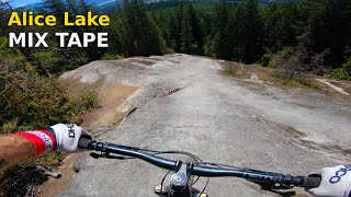
Another legendary trail built by Gary McFarlane, The trail is an easy black, with optional intermediate options (all signed with a chicken).

The trail offers so many different styles of riding - XC, rock slabs, downhill rips, and some interesting wood-work. Definitely one of the highlight trails of the 2013/14 building season.

Trail Supporters
Local Trail Association
Traditionally Indigenous Territory

Recent Activity on Trail

Past Week
  • 27 rides
  • 16 miles average
6 Months
  • 546 rides
  • 13 miles avg distance
All
  • 6,216 rides
  • Last: Jun 26, 2026
c1c2c3c4
January
February
March
April
May
June
July
August
September
October
November
December
Status:
on Jun 19, 2026
Ideal
Avg: 4.72 (223 votes)
Your vote: 0

view (42,506)
close
3D
Trail Conditions
  • Unknown
  • Snow Groomed
  • Snow Packed
  • Snow Covered
  • Snow Cover Partial
  • Freeze/thaw Cycle
  • Icy
  • Prevalent Mud
  • Wet
  • Variable
  • Ideal
  • Dry
  • Very Dry
Trail Flow (Ridden Direction)
Trailforks scans users ridelogs to determine the most popular direction each trail is ridden. A good flowing trail network will have most trails flowing in a single direction according to their intension.
The colour categories are based on what percentage of riders are riding a trail in its intended direction.
  • > 96%
  • > 90%
  • > 80%
  • > 70%
  • > 50%
  • < 50%
  • bi-directional trail
  • no data
Trail Last Ridden
Trailforks scans ridelogs to determine the last time a trail was ridden.
  • < 2 days
  • < 1 week
  • < 2 weeks
  • < 1 month
  • < 6 months
  • > 6 months
Trail Ridden Direction
The intended direction a trail should be ridden.
  • Downhill Only
  • Downhill Primary
  • Both Directions
  • Uphill Primary
  • Uphill Only
  • One Direction
Contribute Details
Colors indicate trail is missing specified detail.
  • Description
  • Photos
  • Description & Photos
  • Videos
Trail Popularity ?
Trailforks scans ridelogs to determine which trails are ridden the most in the last 9 months. Trails are compared with nearby trails in the same city region with a possible 25 colour shades. Think of this as a heatmap, more rides = more kinetic energy = warmer colors.
  • most popular
  • popular
  • less popular
  • not popular
ATV/ORV/OHV Filter
Max Vehicle Width
inches
US Cell Coverage
Legend
cell carrier legend

Radar Time
Activity Recordings
Trailforks uses anonymized public activity data. ?
Activity Recordings
Trailforks uses anonymized public activity data. ?
Personal Heatmap
Activity Types
all / none
Options
2
Date range month
Winter Trails
Warning A routing network for winter maps does not exist. Selecting trails using the winter trails layer has been disabled.
Missing Trails
Most Popular
Least Popular
Trails are colored based on popularity. The more popular a trail is, the more red. Less popular trails trend towards green.
Jump Magnitude Heatmap
Heatmap of where riders jump on trails. Zoom in to see individual jumps, click circles to view jump details.
BC Backroad Status

Service Road Atlas is a free to use, community-driven service for viewing and creating reports on the numerous back-country service roads around B.C. and Alberta.

map legend
Slope Aspect
Direction the slope faces
Flat N NE E SE S SW W NW
Trails Deemphasized
Trails are shown in grey.
disable
Only show trails with no bike usage.
Enable
Suggested Layers
Based on selected activity type

    Save the current map location and zoom level as your default home location whenever this page is loaded.

    Save
        Directions to rupert trailhead (49.767890, -123.112190)

        Photos

        286 more »
        4,136 |
        Sep 13, 2017 @ 10:58am
        Sep 13, 2017
        1,597 |
        Aug 28, 2017 @ 5:39pm
        Aug 28, 2017
        2,202 |
        Aug 28, 2017 @ 5:39pm
        Aug 28, 2017
        125 |
        Sep 20, 2024 @ 10:12pm
        Sep 20, 2024

        Videos

        94 more »
        youtuber TOP TEN ROCKS TO ROLL in SQUAMISH, BC  ALICE...
        10:40 | 1551 | Mar 24, 2020 , Squamish
        youtuber Squamish 2017: Alice Lake 'Rupert',...
        7:35 | 2858 | Sep 18, 2017 , Squamish
        youtuber Alice Lake Mix Tape | Squamish, BC
        5:05 | 355 | Apr 26, 2024 , Squamish
        youtuber Are These Trails Too Hard For Us?  (Squamish, BC)
        17:20 | 366 | Oct 15, 2023 , Squamish

        Articles

        Video: Remy Metailler Guides 4 Riders Down Rupert in Squamish for the First Time
        Nov 25, 2021 from pinkbike.com
        Remy Metailler meets up with Judy, the founder of Colour The Trails and three friends to ride Rupert, in Squamish.

        Trail Lists

        Routes with this trail

        4.3 7 miles 1,073 ft 14 Loop
        This is a classic intermediate/advanced Squamish trail ride. It can be ridden in an hour if you are...
        5.0 5 miles 755 ft 8 Loop
        Check out or recommended route for the Alice Lakes & Highlands zone!
        5 miles 756 ft 7

        18 Reviews & Comments


        We hope you've been enjoying Trailforks!

        Create a FREE account to view trail comments and much more.

        • By canadakaTF Pro Trailforks & contributors
        • #3527 - 67,476 views

        Frequently Asked Questions About Rupert

        Where is Rupert located?
        Rupert is located in Alice Lake & Highlands, Squamish, British Columbia, Canada. It is part of the Alice Lake & Highlands trail network. The trailhead is located at coordinates 49.76789, -123.11219.
        How hard is Rupert?
        Rupert is rated as Black Diamond difficulty. The average grade is 7.5%.
        What is the elevation gain for Rupert?
        Rupert has 27 ft of elevation gain. The trail has 289 ft of elevation descent. The elevation ranges from 910 ft to 1,192 ft.
        Is Rupert a point to point trail?
        Yes, Rupert is a point to point trail. The direction is Downhill Only. The trail type is singletrack.

        Hit the Trail

        Open in App

        Get this trail on your phone instantly.
        open trail in app

        Download Trail

        Save to wishlist, Garmin & download.
        save the trail

        Find Related Routes

        Find routes and users activities that include this trail.
        find routes for this trail

        You must enter a description before submitting.