more stats
3.0 miles
Distance
559 ft
Climb
-577 ft
Descent
00:35:32
Avg time
-18 ft
Altitude change
9,296 ft
Altitude min
9,558 ft
Altitude max
9,334 ft
Altitude start
9,314 ft
Altitude end
-0.1%
Grade
-33.1%
Grade max
55.4%
Grade min
1 mile
Distance climb
1 mile
Distance down
3,054 ft
Distance flat
00:35:32
Avg time

Rusty Buckle Details

  • Activities
    • Mountain Bike
    • Horse
    • Hike
    • Trail Running
  • Riding Area
    Staunton State Park
    Conifer, Colorado
  • Ref Number
    #769
  • Difficulty Rating
  • Local Popularity
    90 in Mountain Biking [+]
    • 45 in Trail Running
    • 5 in Hiking
    • 5 in Horseback
  • Trail Type
    Singletrack
  • Bike Type
    XC
  • Direction
    Both Directions
    Popular Direction Shown
  • Climb Difficulty
    Blue
  • Physical Rating
    Hard
  • Trail Visibility
    Always easy to follow
  • Alpine Trail
    Yes
  • Dogs Allowed
    Yes
  • eBike Allowed
  • TTFs on Trail
    Rock Garden
  • Year Opened
    2022
  • Land Owner
    South Platte Ranger District

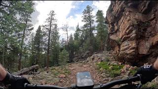
New (as of June 2022) trail in the North Elk Creek trail system north of Staunton State Park. Best ridden clockwise from Border Line and North Elk Extension.

Access Info

ANNUAL CLOSURE of the North Elk Trail area occurs from March 1st thru June 15th for wildlife protection and to prevent damage during mud season.

Disclaimer

E-bikes not allowed on any non-motorized NFS trail including: North Elk Creek 764, Cub Creek 40, or Rusty Buckle 769.

Trail Supporters
Local Trail Association
Traditionally Indigenous Territory

Recent Activity on Trail

Past Week
  • 2 rides
  • 15 miles average
6 Months
  • 10 rides
  • 13 miles avg distance
All
  • 387 rides
  • Last: Jun 18, 2026
c1c2c3c4
January
February
March
April
May
June
July
August
September
October
November
December
update trails status or condition

Rusty Buckle Trail Reports

statusdatedescription
Jun 16, 2026 @ 9:29pm (America/Denver)
3 days
All trees cleared as of 6/16
Jun 16, 2026 @ 3:57pm (America/Denver)
3 days
North Elk Ext and Rusty Buckle just opened after seasonal closure. Signs at start of both trails warn of downed trees from wind damage. As of 6/16...
Jan 10, 2026 @ 11:30am (America/Denver)
Jan 10, 2026
Many downed trees at the top of Rusty Buckle near Borderline.
Oct 23, 2025 @ 11:31am (America/Denver)
Oct 23, 2025
Small tree down across trail, can navigate over or around
Oct 11, 2025 @ 8:23am (America/Denver)
Oct 11, 2025
more »
Status:
on Jun 16, 2026
Ideal
Avg: 4.19 (4 votes)
Your vote: 0

view (1,429)
close
3D
Trail Conditions
  • Unknown
  • Snow Groomed
  • Snow Packed
  • Snow Covered
  • Snow Cover Partial
  • Freeze/thaw Cycle
  • Icy
  • Prevalent Mud
  • Wet
  • Variable
  • Ideal
  • Dry
  • Very Dry
Trail Flow (Ridden Direction)
Trailforks scans users ridelogs to determine the most popular direction each trail is ridden. A good flowing trail network will have most trails flowing in a single direction according to their intension.
The colour categories are based on what percentage of riders are riding a trail in its intended direction.
  • > 96%
  • > 90%
  • > 80%
  • > 70%
  • > 50%
  • < 50%
  • bi-directional trail
  • no data
Trail Last Ridden
Trailforks scans ridelogs to determine the last time a trail was ridden.
  • < 2 days
  • < 1 week
  • < 2 weeks
  • < 1 month
  • < 6 months
  • > 6 months
Trail Ridden Direction
The intended direction a trail should be ridden.
  • Downhill Only
  • Downhill Primary
  • Both Directions
  • Uphill Primary
  • Uphill Only
  • One Direction
Contribute Details
Colors indicate trail is missing specified detail.
  • Description
  • Photos
  • Description & Photos
  • Videos
Trail Popularity ?
Trailforks scans ridelogs to determine which trails are ridden the most in the last 9 months. Trails are compared with nearby trails in the same city region with a possible 25 colour shades. Think of this as a heatmap, more rides = more kinetic energy = warmer colors.
  • most popular
  • popular
  • less popular
  • not popular
ATV/ORV/OHV Filter
Max Vehicle Width
inches
US Cell Coverage
Legend
cell carrier legend

Radar Time
Activity Recordings
Trailforks uses anonymized public activity data. ?
Activity Recordings
Trailforks uses anonymized public activity data. ?
Personal Heatmap
Activity Types
all / none
Options
2
Date range month
Winter Trails
Warning A routing network for winter maps does not exist. Selecting trails using the winter trails layer has been disabled.
Missing Trails
Most Popular
Least Popular
Trails are colored based on popularity. The more popular a trail is, the more red. Less popular trails trend towards green.
Jump Magnitude Heatmap
Heatmap of where riders jump on trails. Zoom in to see individual jumps, click circles to view jump details.
BC Backroad Status

Service Road Atlas is a free to use, community-driven service for viewing and creating reports on the numerous back-country service roads around B.C. and Alberta.

map legend
Slope Aspect
Direction the slope faces
Flat N NE E SE S SW W NW
Trails Deemphasized
Trails are shown in grey.
disable
Only show trails with no bike usage.
Enable
Suggested Layers
Based on selected activity type

    Save the current map location and zoom level as your default home location whenever this page is loaded.

    Save
        Directions to rusty-buckle-548130 trailhead (39.534100, -105.419090)

        Photos

        9 more »
        137 |
        Sep 25, 2022 @ 9:11am
        Sep 25, 2022
        129 |
        Sep 25, 2022 @ 9:11am
        Sep 25, 2022
        236 |
        Jul 22, 2022 @ 1:50pm
        Jul 22, 2022
        214 |
        Jul 19, 2022 @ 8:59am
        Jul 19, 2022

        Videos

        1 more »
        Rusty Buckle - Staunton State Park - Conifer -...
        12:58 | 165 | Jun 25, 2024 , Conifer

        Routes with this trail

        5.0 38 miles 6,920 ft 19 Loop
        A stellar way to ride Staunton SP with the added bonus of climbing over the shoulder of Black Mtn. The...
        22 miles 3,789 ft 15 Loop
        Highlighting the best trails within the park without doubling back and running the newly added and Rusty...
        21 miles 3,517 ft 13 Loop
        A fun loop that includes the newly built Rusty Buckle trail. Note that eBikes are not allowed on Rusty...

        7 Reviews & Comments


        We hope you've been enjoying Trailforks!

        Create a FREE account to view trail comments and much more.

        • By Dknoxy COMBA & contributors
        • #548130 - 3,362 views

        Hit the Trail

        Open in App

        Get this trail on your phone instantly.
        open trail in app

        Download Trail

        Save to wishlist, Garmin & download.
        save the trail

        Find Related Routes

        Find routes and users activities that include this trail.
        find routes for this trail

        You must enter a description before submitting.