more stats
4,249 ft
Distance
-777 ft
Descent
00:18:07
Avg time
-777 ft
Altitude change
1,581 ft
Altitude min
2,359 ft
Altitude max
2,359 ft
Altitude start
1,581 ft
Altitude end
-18.3%
Grade
-62.2%
Grade max
23 ft
Distance climb
4,193 ft
Distance down
33 ft
Distance flat
00:18:07
Avg time

Rusty Trombone Details

  • Activities
    • Mountain Bike
    • E-Bike
    • Hike
    • Trail Running
  • Riding Area
    Mackenzie
    Pemberton, British Columbia
  • Difficulty Rating
  • Voted Difficulty
    Black Diamond (5 votes)
  • Local Popularity
    85 in Mountain Biking [+]
    • 90 in E-Biking
    • 55 in Trail Running
    • 35 in Hiking
  • Global Ranking
    #28906 in Mountain Biking [+]
    • #10137 in E-Biking
    • #98455 in Trail Running
    • #111445 in Hiking
  • Trail Type
    Singletrack
  • Dogs Allowed
    Yes
  • eBike Allowed
    Yes up to Class 1

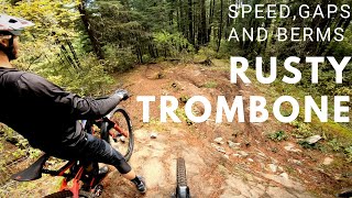
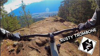
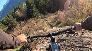
Great fun. Several slabs and different options up top, while the lower portion has been reworked with berms, jumps and optional drops. A step up in difficulty from Overnight Sensation, but well worth it. Check it out

Access Info

100m past the entrance of Overnight Sensation

Local Trail Association
Traditionally Indigenous Territory

Recent Activity on Trail

Past Week
  • 0 rides
  •  
6 Months
  • 48 rides
  • 11 miles avg distance
All
  • 566 rides
  • Last: May 30, 2026
c1c2c3c4
January
February
March
April
May
June
July
August
September
October
November
December
update trails status or condition

Rusty Trombone Trail Reports

Status:
on May 20, 2026
Dry
Avg: 4.38 (33 votes)
Your vote: 0

view (3,752)
close
3D
Trail Conditions
  • Unknown
  • Snow Groomed
  • Snow Packed
  • Snow Covered
  • Snow Cover Partial
  • Freeze/thaw Cycle
  • Icy
  • Prevalent Mud
  • Wet
  • Variable
  • Ideal
  • Dry
  • Very Dry
Trail Flow (Ridden Direction)
Trailforks scans users ridelogs to determine the most popular direction each trail is ridden. A good flowing trail network will have most trails flowing in a single direction according to their intension.
The colour categories are based on what percentage of riders are riding a trail in its intended direction.
  • > 96%
  • > 90%
  • > 80%
  • > 70%
  • > 50%
  • < 50%
  • bi-directional trail
  • no data
Trail Last Ridden
Trailforks scans ridelogs to determine the last time a trail was ridden.
  • < 2 days
  • < 1 week
  • < 2 weeks
  • < 1 month
  • < 6 months
  • > 6 months
Trail Ridden Direction
The intended direction a trail should be ridden.
  • Downhill Only
  • Downhill Primary
  • Both Directions
  • Uphill Primary
  • Uphill Only
  • One Direction
Contribute Details
Colors indicate trail is missing specified detail.
  • Description
  • Photos
  • Description & Photos
  • Videos
Trail Popularity ?
Trailforks scans ridelogs to determine which trails are ridden the most in the last 9 months. Trails are compared with nearby trails in the same city region with a possible 25 colour shades. Think of this as a heatmap, more rides = more kinetic energy = warmer colors.
  • most popular
  • popular
  • less popular
  • not popular
ATV/ORV/OHV Filter
Max Vehicle Width
inches
US Cell Coverage
Legend
cell carrier legend

Radar Time
Activity Recordings
Trailforks uses anonymized public activity data. ?
Activity Recordings
Trailforks uses anonymized public activity data. ?
Personal Heatmap
Activity Types
all / none
Options
2
Date range month
Winter Trails
Warning A routing network for winter maps does not exist. Selecting trails using the winter trails layer has been disabled.
Missing Trails
Most Popular
Least Popular
Trails are colored based on popularity. The more popular a trail is, the more red. Less popular trails trend towards green.
Jump Magnitude Heatmap
Heatmap of where riders jump on trails. Zoom in to see individual jumps, click circles to view jump details.
BC Backroad Status

Service Road Atlas is a free to use, community-driven service for viewing and creating reports on the numerous back-country service roads around B.C. and Alberta.

map legend
Slope Aspect
Direction the slope faces
Flat N NE E SE S SW W NW
Trails Deemphasized
Trails are shown in grey.
disable
Only show trails with no bike usage.
Enable
Suggested Layers
Based on selected activity type

    Save the current map location and zoom level as your default home location whenever this page is loaded.

    Save
        Directions to rusty-trombone trailhead (50.341790, -122.772450)

        Photos

        69 more »
        1,487 |
        Apr 12, 2016 @ 5:50pm
        Apr 12, 2016
        2,441 |
        Feb 15, 2015 @ 10:54pm
        Feb 15, 2015
        26 |
        Apr 11, 2025 @ 10:25pm
        Apr 11, 2025
        144 |
        Nov 22, 2023 @ 8:25pm
        Nov 22, 2023

        Videos

        9 more »
        youtuber Trail Preview | Rusty Trombone and Blood,...
        14:12 | 1376 | Sep 26, 2019 , Pemberton
        youtuber RUSTY TROMBONE | Double black trail | Pemberton
        5:44 | 416 | Nov 28, 2023 , Pemberton
        youtuber Whistler MTB Singletrack Heaven - Micro...
        19:25 | 129 | Mar 17, 2025 , Pemberton
        Rusty Trombone
        3:33 | 645 | Nov 16, 2023 , Pemberton

        Trail Lists

        Routes with this trail

        3.0 18 miles 4,659 ft 35
        The 2018 Pemberton Enduro course offers up an excellent variety of Pemberton's trail styles and is...
        8 miles 1,407 ft 19
        Beyond Worx lap. Follow the bread crumbs.
        10 miles 2,921 ft 52
        A couple of laps to include Overnight Sensation and Rusty Trombone

        Trail Products

        3 Reviews & Comments


        We hope you've been enjoying Trailforks!

        Create a FREE account to view trail comments and much more.

        Frequently Asked Questions About Rusty Trombone

        Where is Rusty Trombone located?
        Rusty Trombone is located in Mackenzie, Pemberton, British Columbia, Canada. It is part of the Mackenzie trail network. The trailhead is located at coordinates 50.34179, -122.77245.
        How hard is Rusty Trombone?
        Rusty Trombone is rated as Black Diamond difficulty. The average grade is 18.3%.
        What is the elevation gain for Rusty Trombone?
        The trail has 237 m of elevation descent. The elevation ranges from 482 m to 719 m.
        How long is Rusty Trombone?
        Rusty Trombone is 1.3 km long. The trail type is singletrack.

        Hit the Trail

        Open in App

        Get this trail on your phone instantly.
        open trail in app

        Download Trail

        Save to wishlist, Garmin & download.
        save the trail

        Find Related Routes

        Find routes and users activities that include this trail.
        find routes for this trail

        You must enter a description before submitting.