more stats
3,537 ft
Distance
3 ft
Climb
-503 ft
Descent
00:08:56
Avg time
-500 ft
Altitude change
595 ft
Altitude min
1,098 ft
Altitude max
1,096 ft
Altitude start
597 ft
Altitude end
-14.1%
Grade
-52%
Grade max
2.8%
Grade min
102 ft
Distance climb
3,196 ft
Distance down
236 ft
Distance flat
00:08:56
Avg time

Sa Creu Details

  • Activities
    • Mountain Bike
    • E-Bike
    • Hike
    • Trail Running
  • Riding Area
  • Difficulty Rating
  • Local Popularity
    50 in Mountain Biking [+]
    • 90 in E-Biking
    • 5 in Trail Running
    • 5 in Hiking
  • Global Ranking
    #72673 in Mountain Biking [+]
    • #18943 in E-Biking
    • #130987 in Trail Running
    • #124098 in Hiking
  • Hiking SAC Scale
    T1 Hiking
  • Trail Type
    Singletrack
  • Bike Type
    DH, AM
  • Direction
    Downhill Primary
    Popular Direction Shown
  • Climb Difficulty
    Black Diamond
  • Physical Rating
    Hard
  • Trail Visibility
    Always easy to follow
  • Season
    All year
  • Dogs Allowed
    Yes
  • eBike Allowed
    Yes up to Class 1
  • TTFs on Trail
    Drop, Jump
  • Ride in Rain
    Yes

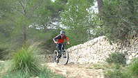
Great trail with jumps, drops and some steep sections. It's a good idea to check before as its is being constantly worked on and new features can give you a nasty surprise

Access Info

Take the PMV 1043 from the Genova Turning on the Via Centura.

Recent Activity on Trail

Past Week
  • 0 rides
  •  
6 Months
  • 1 rides
  • 14 miles avg distance
All
  • 29 rides
  • Last: Apr 25, 2026
c1c2c3c4
January
February
March
April
May
June
July
August
September
October
November
December
update trails status or condition

Sa Creu Trail Reports

statusdatedescription
Dec 21, 2025 @ 1:13pm (Africa/Algiers)
Dec 21, 2025
reporter
Nov 11, 2024 @ 9:49am
Nov 11, 2024
Large tree down across trail, blocking trail in final section. Can go around but blocks a jump. Otherwise in good shape, little loose with all the...
Oct 25, 2024 @ 9:29am
Oct 25, 2024
Sep 28, 2024 @ 3:40pm
Sep 28, 2024
la lluvia de hoy ha dejado los senderos perfectos
Apr 3, 2023 @ 4:42pm
Apr 3, 2023
more »
Status:
on Dec 21, 2025
Variable
Avg: 4.5 (8 votes)
Your vote: 0

view (295)
close
3D
Trail Conditions
  • Unknown
  • Snow Groomed
  • Snow Packed
  • Snow Covered
  • Snow Cover Partial
  • Freeze/thaw Cycle
  • Icy
  • Prevalent Mud
  • Wet
  • Variable
  • Ideal
  • Dry
  • Very Dry
Trail Flow (Ridden Direction)
Trailforks scans users ridelogs to determine the most popular direction each trail is ridden. A good flowing trail network will have most trails flowing in a single direction according to their intension.
The colour categories are based on what percentage of riders are riding a trail in its intended direction.
  • > 96%
  • > 90%
  • > 80%
  • > 70%
  • > 50%
  • < 50%
  • bi-directional trail
  • no data
Trail Last Ridden
Trailforks scans ridelogs to determine the last time a trail was ridden.
  • < 2 days
  • < 1 week
  • < 2 weeks
  • < 1 month
  • < 6 months
  • > 6 months
Trail Ridden Direction
The intended direction a trail should be ridden.
  • Downhill Only
  • Downhill Primary
  • Both Directions
  • Uphill Primary
  • Uphill Only
  • One Direction
Contribute Details
Colors indicate trail is missing specified detail.
  • Description
  • Photos
  • Description & Photos
  • Videos
Trail Popularity ?
Trailforks scans ridelogs to determine which trails are ridden the most in the last 9 months. Trails are compared with nearby trails in the same city region with a possible 25 colour shades. Think of this as a heatmap, more rides = more kinetic energy = warmer colors.
  • most popular
  • popular
  • less popular
  • not popular
ATV/ORV/OHV Filter
Max Vehicle Width
inches
US Cell Coverage
Legend
cell carrier legend

Radar Time
Activity Recordings
Trailforks uses anonymized public activity data. ?
Activity Recordings
Trailforks uses anonymized public activity data. ?
Personal Heatmap
Activity Types
all / none
Options
2
Date range month
Winter Trails
Warning A routing network for winter maps does not exist. Selecting trails using the winter trails layer has been disabled.
Missing Trails
Most Popular
Least Popular
Trails are colored based on popularity. The more popular a trail is, the more red. Less popular trails trend towards green.
Jump Magnitude Heatmap
Heatmap of where riders jump on trails. Zoom in to see individual jumps, click circles to view jump details.
BC Backroad Status

Service Road Atlas is a free to use, community-driven service for viewing and creating reports on the numerous back-country service roads around B.C. and Alberta.

map legend
Slope Aspect
Direction the slope faces
Flat N NE E SE S SW W NW
Trails Deemphasized
Trails are shown in grey.
disable
Only show trails with no bike usage.
Enable
Suggested Layers
Based on selected activity type

    Save the current map location and zoom level as your default home location whenever this page is loaded.

    Save
        Directions to sa-creu trailhead (39.581330, 2.574070)

        Photos

        21 more »
        93 |
        Feb 6, 2024 @ 9:14am
        Feb 6, 2024
        52 |
        Feb 6, 2024 @ 9:14am
        Feb 6, 2024
        62 |
        Feb 6, 2024 @ 9:14am
        Feb 6, 2024
        60 |
        Feb 6, 2024 @ 9:14am
        Feb 6, 2024

        Videos

        1 more »
        Mallorca Downhill
        0:00 | 708 | Jan 4, 2018 , Palma de Mallorca

        1 Review & Comments


        We hope you've been enjoying Trailforks!

        Create a FREE account to view trail comments and much more.

        • By mallorcadave & contributors
        • #21408 - 3,163 views

        Frequently Asked Questions About Sa Creu

        Where is Sa Creu located?
        Sa Creu is located in Palma de Mallorca, Spain. It is part of the Palma de Mallorca trail network. The trailhead is located at coordinates 39.58133, 2.57407.
        How hard is Sa Creu?
        Sa Creu is rated as Black difficulty. The physical rating is Hard. The average grade is 14.1%. The climb difficulty is rated Black Diamond.
        What is the elevation gain for Sa Creu?
        Sa Creu has 3 ft of elevation gain. The trail has 503 ft of elevation descent. The elevation ranges from 595 ft to 1,098 ft.
        Is Sa Creu a point to point trail?
        Sa Creu is not a point to point trail. The direction is Downhill Primary. The trail type is singletrack.

        Hit the Trail

        Open in App

        Get this trail on your phone instantly.
        open trail in app

        Download Trail

        Save to wishlist, Garmin & download.
        save the trail

        Find Related Routes

        Find routes and users activities that include this trail.
        find routes for this trail

        You must enter a description before submitting.