more stats
2,982 ft
Distance
-470 ft
Descent
00:02:07
Avg time
-470 ft
Altitude change
4,615 ft
Altitude min
5,084 ft
Altitude max
5,084 ft
Altitude start
4,616 ft
Altitude end
-15.8%
Grade
-56.9%
Grade max
-6.3%
Grade min
2,976 ft
Distance down
7 ft
Distance flat
00:02:07
Avg time

Saliere Details

  • Activities
    • Mountain Bike
    • E-Bike
    • Winter Fat Bike
  • Riding Area
  • Difficulty Rating
  • Local Popularity
    100 in Mountain Biking [+]
    • 95 in E-Biking
  • Global Ranking
    #3931 in Mountain Biking [+]
    • #17090 in E-Biking
  • Trail Type
    Singletrack
  • Bike Type
    DH, AM, XC, Fat
  • Direction
    Downhill Only
    Popular Direction Shown
  • Trail Visibility
    Always easy to follow
  • Season
    Springtime, Summer, Fall
  • eBike Allowed
    Yes up to Class 1
  • Land Owner

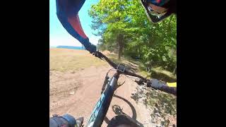
Saliere is the easiest run of the Frontignano Bike Park. Flowy and funny with a small ramp at the end. The ramp has a chicken line. This is a lift-served run.

Access Info

From Rifugio delle Saliere or From Pino Torto Intro

Trail Supporters

Bike Park

Recent Activity on Trail

Past Week
  • 0 rides
  •  
6 Months
  • 1 rides
  • 22 miles avg distance
All
  • 47 rides
  • Last: May 31, 2026
c1c2c3c4
January
February
March
April
May
June
July
August
September
October
November
December
Status:
on Oct 11, 2025
Ideal
Avg: 4.08 (5 votes)
Your vote: 0

view (543)
close
3D
Trail Conditions
  • Unknown
  • Snow Groomed
  • Snow Packed
  • Snow Covered
  • Snow Cover Partial
  • Freeze/thaw Cycle
  • Icy
  • Prevalent Mud
  • Wet
  • Variable
  • Ideal
  • Dry
  • Very Dry
Trail Flow (Ridden Direction)
Trailforks scans users ridelogs to determine the most popular direction each trail is ridden. A good flowing trail network will have most trails flowing in a single direction according to their intension.
The colour categories are based on what percentage of riders are riding a trail in its intended direction.
  • > 96%
  • > 90%
  • > 80%
  • > 70%
  • > 50%
  • < 50%
  • bi-directional trail
  • no data
Trail Last Ridden
Trailforks scans ridelogs to determine the last time a trail was ridden.
  • < 2 days
  • < 1 week
  • < 2 weeks
  • < 1 month
  • < 6 months
  • > 6 months
Trail Ridden Direction
The intended direction a trail should be ridden.
  • Downhill Only
  • Downhill Primary
  • Both Directions
  • Uphill Primary
  • Uphill Only
  • One Direction
Contribute Details
Colors indicate trail is missing specified detail.
  • Description
  • Photos
  • Description & Photos
  • Videos
Trail Popularity ?
Trailforks scans ridelogs to determine which trails are ridden the most in the last 9 months. Trails are compared with nearby trails in the same city region with a possible 25 colour shades. Think of this as a heatmap, more rides = more kinetic energy = warmer colors.
  • most popular
  • popular
  • less popular
  • not popular
ATV/ORV/OHV Filter
Max Vehicle Width
inches
US Cell Coverage
Legend
cell carrier legend

Radar Time
Activity Recordings
Trailforks uses anonymized public activity data. ?
Activity Recordings
Trailforks uses anonymized public activity data. ?
Personal Heatmap
Activity Types
all / none
Options
2
Date range month
Winter Trails
Warning A routing network for winter maps does not exist. Selecting trails using the winter trails layer has been disabled.
Missing Trails
Most Popular
Least Popular
Trails are colored based on popularity. The more popular a trail is, the more red. Less popular trails trend towards green.
Jump Magnitude Heatmap
Heatmap of where riders jump on trails. Zoom in to see individual jumps, click circles to view jump details.
BC Backroad Status

Service Road Atlas is a free to use, community-driven service for viewing and creating reports on the numerous back-country service roads around B.C. and Alberta.

map legend
Slope Aspect
Direction the slope faces
Flat N NE E SE S SW W NW
Trails Deemphasized
Trails are shown in grey.
disable
Only show trails with no bike usage.
Enable
Suggested Layers
Based on selected activity type

    Save the current map location and zoom level as your default home location whenever this page is loaded.

    Save
        Directions to saliere trailhead (42.914020, 13.172080)

        Photos

        10 more »
        52 |
        Jun 19, 2023 @ 2:18pm
        Jun 19, 2023
        31 |
        May 19, 2022 @ 9:33am
        May 19, 2022
        35 |
        May 19, 2022 @ 9:33am
        May 19, 2022
        31 |
        May 19, 2022 @ 9:33am
        May 19, 2022

        Videos

        1 more »
        BIKE BOX TEAM in Saliere
        3:07 | 33 | Nov 8, 2025 , Ussita

        Reviews / Comments

        No reviews yet, be the first to write a review or ask a question.
        Use trail reports to comment on trail conditions.


        We hope you've been enjoying Trailforks!

        Create a FREE account to view trail comments and much more.

        • By vettoreTF Pro & contributors
        • #435155 - 582 views

        Frequently Asked Questions About Saliere

        Where is Saliere located?
        Saliere is located in Frontignano Bike Park, Ussita, Italy. It is part of the Frontignano Bike Park trail network. The trailhead is located at coordinates 42.91402, 13.17208.
        How hard is Saliere?
        Saliere is rated as Green difficulty. The average grade is 15.8%.
        What is the elevation gain for Saliere?
        The trail has 470 ft of elevation descent. The elevation ranges from 4,615 ft to 5,084 ft.
        Is Saliere a point to point trail?
        Yes, Saliere is a point to point trail. The direction is Downhill Only. The trail type is singletrack.

        Hit the Trail

        Open in App

        Get this trail on your phone instantly.
        open trail in app

        Download Trail

        Save to wishlist, Garmin & download.
        save the trail

        Find Related Routes

        Find routes and users activities that include this trail.
        find routes for this trail

        You must enter a description before submitting.