more stats
1.9 miles
Distance
139 ft
Climb
-914 ft
Descent
00:35:00
Avg time
-776 ft
Altitude change
4,524 ft
Altitude min
5,394 ft
Altitude max
5,300 ft
Altitude start
4,524 ft
Altitude end
-7.9%
Grade
-72.8%
Grade max
28.6%
Grade min
2,457 ft
Distance climb
1 mile
Distance down
184 ft
Distance flat
00:35:00
Avg time

Sam Merrill (Upper) Details

  • Activities
    • Mountain Bike
    • Hike
    • Trail Running
  • Riding Area
    Angeles National Forest
    Pasadena, California
  • Ref Number
    12W14.3
  • AKA
    Sam Merrill (Upper) 12W14.3
  • Difficulty Rating
  • Local Popularity
    75 in Mountain Biking [+]
    • 80 in Trail Running
    • 60 in Hiking
  • Global Ranking
    #62494 in Mountain Biking [+]
    • #78353 in Trail Running
    • #103363 in Hiking
  • Trail Type
    Singletrack
  • Bike Type
    DH, AM
  • Direction
    Downhill Primary
    Popular Direction Shown
  • Climb Difficulty
    Green
  • Physical Rating
    Moderate
  • Season
    year round
  • Dogs Allowed
    Yes
  • eBike Allowed
  • TTFs on Trail
    Roller Coaster
  • Ride in Rain
    Yes
  • Land Owner

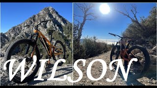
Coming down from the paved road near Mt Wilson, Upper Sam Merrill is the 1st single track trail to the left after coming thru the old tunnel.

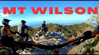
You climb the Mt Lowe Fireroad to a three way fire road junction and you will see the Mt Lowe East trail to the far left. The single track starts with a couple of rock steps and climbs to a metal trail sign labeled Mt Lowe / Mt Wilson. Mt Lowe East / Merrill Upper single track is very narrow, loose, and exposed. There are many 180 switchbacks and areas where you may prefer to walk over ride. There are a number of "chutes" that go straight down so be careful and be aware the regular trail always switchbacks at these points and is safer. Competent DH riders may prefer the straight "chutes" where All Mountain riders may prefer the standard trail which is still very challenging. This trail demands focus and attention its entire length.

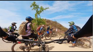
The trail reconnects to Mt Lowe Fire Road and you continue down to the junction of Middle Sam Merrell Trail and Inspiration Point. Inspiration Point is to the left at this junction and is well worth the short climb for the historic view. Descending Middle Merrill from here is a classic trail with similar conditions to Mt Lowe East. Be aware that you will likely encounter many hikers as you get closer to Echo Mountain.

Using a bell on your bicycle is highly recommended.

Trail Supporters

  • USFS
    Land Manager
Local Trail Association
Traditionally Indigenous Territory

Recent Activity on Trail

Past Week
  • 0 rides
  •  
6 Months
  • 17 rides
  • 12 miles avg distance
All
  • 118 rides
  • Last: May 30, 2026
c1c2c3c4
January
February
March
April
May
June
July
August
September
October
November
December
update trails status or condition

Sam Merrill (Upper) Trail Reports

statusdatedescription
Apr 27, 2026 @ 8:37am (America/Los_Angeles)
Apr 27, 2026
Great trail. Has been cleared and in excellent condition. Exposure and tight switchbacks typical of San Gabes riding.
Jan 25, 2026 @ 9:14am (America/Los_Angeles)
Jan 25, 2026
Very loose
Aug 14, 2024 @ 10:46am
Aug 14, 2024
Very dry, very loose. Not much fun at the moment
Mar 19, 2024 @ 2:04am
Mar 19, 2024
Nov 24, 2023 @ 6:59pm
Nov 24, 2023
more »
Status:
on Apr 27, 2026
Dry
Avg: 4 (19 votes)
Your vote: 0

view (1,533)
close
3D
Trail Conditions
  • Unknown
  • Snow Groomed
  • Snow Packed
  • Snow Covered
  • Snow Cover Partial
  • Freeze/thaw Cycle
  • Icy
  • Prevalent Mud
  • Wet
  • Variable
  • Ideal
  • Dry
  • Very Dry
Trail Flow (Ridden Direction)
Trailforks scans users ridelogs to determine the most popular direction each trail is ridden. A good flowing trail network will have most trails flowing in a single direction according to their intension.
The colour categories are based on what percentage of riders are riding a trail in its intended direction.
  • > 96%
  • > 90%
  • > 80%
  • > 70%
  • > 50%
  • < 50%
  • bi-directional trail
  • no data
Trail Last Ridden
Trailforks scans ridelogs to determine the last time a trail was ridden.
  • < 2 days
  • < 1 week
  • < 2 weeks
  • < 1 month
  • < 6 months
  • > 6 months
Trail Ridden Direction
The intended direction a trail should be ridden.
  • Downhill Only
  • Downhill Primary
  • Both Directions
  • Uphill Primary
  • Uphill Only
  • One Direction
Contribute Details
Colors indicate trail is missing specified detail.
  • Description
  • Photos
  • Description & Photos
  • Videos
Trail Popularity ?
Trailforks scans ridelogs to determine which trails are ridden the most in the last 9 months. Trails are compared with nearby trails in the same city region with a possible 25 colour shades. Think of this as a heatmap, more rides = more kinetic energy = warmer colors.
  • most popular
  • popular
  • less popular
  • not popular
ATV/ORV/OHV Filter
Max Vehicle Width
inches
US Cell Coverage
Legend
cell carrier legend

Radar Time
Activity Recordings
Trailforks uses anonymized public activity data. ?
Activity Recordings
Trailforks uses anonymized public activity data. ?
Personal Heatmap
Activity Types
all / none
Options
2
Date range month
Winter Trails
Warning A routing network for winter maps does not exist. Selecting trails using the winter trails layer has been disabled.
Missing Trails
Most Popular
Least Popular
Trails are colored based on popularity. The more popular a trail is, the more red. Less popular trails trend towards green.
Jump Magnitude Heatmap
Heatmap of where riders jump on trails. Zoom in to see individual jumps, click circles to view jump details.
BC Backroad Status

Service Road Atlas is a free to use, community-driven service for viewing and creating reports on the numerous back-country service roads around B.C. and Alberta.

map legend
Slope Aspect
Direction the slope faces
Flat N NE E SE S SW W NW
Trails Deemphasized
Trails are shown in grey.
disable
Only show trails with no bike usage.
Enable
Suggested Layers
Based on selected activity type

    Save the current map location and zoom level as your default home location whenever this page is loaded.

    Save
        Directions to sam-merrill-upper trailhead (34.239050, -118.099300)

        Photos

        20 more »
        130 |
        Aug 25, 2021 @ 5:52pm
        Aug 25, 2021
        99 |
        Aug 25, 2021 @ 5:52pm
        Aug 25, 2021
        97 |
        Aug 25, 2021 @ 5:52pm
        Aug 25, 2021
        119 |
        Aug 25, 2021 @ 5:52pm
        Aug 25, 2021

        Videos

        10 more »
        youtuber Upper Sam Merrill / Pasadena, CA / MTB
        4:22 | 134 | Jul 15, 2024 , Pasadena
        Wilson Full Ride
        27:31 | 98 | Jul 11, 2023 , Pasadena
        youtuber MT. WILSON
        17:08 | 156 | Apr 11, 2023 , Pasadena
        Mt. Wilson/Eaton Saddle Shuttle Downhill
        1:5:09 | 189 | Jul 27, 2021 , Pasadena

        Routes with this trail

        5.0 8 miles 691 ft 7 Shuttled
        Shuttle run from top of Mt. Lowe East to the bottom of .
        5.0 13 miles 1,514 ft 12 Shuttled
        This shuttle Route is one Variation of the so called Front side riding area in the Angeles National Forest.
        5.0 25 miles 5,728 ft 31 Loop
        Mt wilson mega ride. load up the camelback, this is an all day event.

        Reviews / Comments

        No reviews yet, be the first to write a review or ask a question.
        Use trail reports to comment on trail conditions.


        We hope you've been enjoying Trailforks!

        Create a FREE account to view trail comments and much more.

        • By gooseman310 & contributors
        • #25607 - 6,187 views

        Frequently Asked Questions About Sam Merrill (Upper)

        Where is Sam Merrill (Upper) located?
        Sam Merrill (Upper) is located in Angeles National Forest, Pasadena, California, United States. It is part of the Angeles National Forest trail network. The trailhead is located at coordinates 34.23905, -118.0993.
        How hard is Sam Merrill (Upper)?
        Sam Merrill (Upper) is rated as Black Diamond difficulty. The physical rating is Moderate. The average grade is 7.9%. The climb difficulty is rated Green.
        What is the elevation gain for Sam Merrill (Upper)?
        Sam Merrill (Upper) has 139 ft of elevation gain. The trail has 914 ft of elevation descent. The elevation ranges from 4,524 ft to 5,394 ft.
        Is Sam Merrill (Upper) a point to point trail?
        Sam Merrill (Upper) is not a point to point trail. The direction is Downhill Primary. The trail type is singletrack.

        Hit the Trail

        Open in App

        Get this trail on your phone instantly.
        open trail in app

        Download Trail

        Save to wishlist, Garmin & download.
        save the trail

        Find Related Routes

        Find routes and users activities that include this trail.
        find routes for this trail

        You must enter a description before submitting.