more stats
1,234 ft
Distance
-107 ft
Descent
00:04:46
Avg time
-109 ft
Altitude change
3,828 ft
Altitude min
3,937 ft
Altitude max
3,937 ft
Altitude start
3,829 ft
Altitude end
-8.9%
Grade
-20.8%
Grade max
-1.4%
Grade min
1,211 ft
Distance down
20 ft
Distance flat
00:04:46
Avg time

Sanchez Details

  • Activities
    • Mountain Bike
    • E-Bike
  • Riding Area
    Panorama Mountain Resort
    Panorama, British Columbia
  • Difficulty Rating
  • Local Popularity
    75 in Mountain Biking [+]
    • 95 in E-Biking
  • Global Ranking
    #50436 in Mountain Biking [+]
    • #16372 in E-Biking
  • Trail Type
    Singletrack
  • Bike Type
    AM
  • Direction
    Downhill Primary
    Popular Direction Shown
  • Climb Difficulty
    Green
  • Physical Rating
    Easy
  • Trail Visibility
    Always easy to follow
  • Dogs Allowed
    Yes
  • eBike Allowed
    Yes up to Class 1
  • TTFs on Trail
    Berm, Bridge, Drop, Jump, Ladder Bridge, Log Ride, Rock Garden, Skinny
  • Land Owner

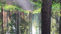
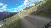
A short trail with many different options of how to make your way to the bottom.

Access Info

Access skiers right tree line beside the Platter Lift, then take the bunny hill (Egress from Sanchez) to climb back up.

Bike Park

Recent Activity on Trail

Past Week
  • 0 rides
  •  
6 Months
  • 1 rides
  • 5 miles avg distance
All
  • 101 rides
  • Last: Jun 15, 2026
c1c2c3c4
January
February
March
April
May
June
July
August
September
October
November
December
update trails status or condition

Sanchez Trail Reports

statusdatedescription
May 21, 2026 @ 12:20pm (America/Edmonton)
May 21, 2026
reporter Hero dirt
May 12, 2026 @ 11:35am (America/Edmonton)
May 12, 2026
trail crew has been grooming the path, everything's in great shape
Sep 14, 2025 @ 1:08pm (America/Creston)
Sep 14, 2025
Sep 2, 2025 @ 9:33am
Sep 2, 2025
-- Trail Closed for the 2025 Season --
May 25, 2025 @ 9:57am
May 25, 2025
more »
Status:
on May 21, 2026
Ideal
Avg: 4.52 (11 votes)
Your vote: 0

view (1,030)
close
3D
Trail Conditions
  • Unknown
  • Snow Groomed
  • Snow Packed
  • Snow Covered
  • Snow Cover Partial
  • Freeze/thaw Cycle
  • Icy
  • Prevalent Mud
  • Wet
  • Variable
  • Ideal
  • Dry
  • Very Dry
Trail Flow (Ridden Direction)
Trailforks scans users ridelogs to determine the most popular direction each trail is ridden. A good flowing trail network will have most trails flowing in a single direction according to their intension.
The colour categories are based on what percentage of riders are riding a trail in its intended direction.
  • > 96%
  • > 90%
  • > 80%
  • > 70%
  • > 50%
  • < 50%
  • bi-directional trail
  • no data
Trail Last Ridden
Trailforks scans ridelogs to determine the last time a trail was ridden.
  • < 2 days
  • < 1 week
  • < 2 weeks
  • < 1 month
  • < 6 months
  • > 6 months
Trail Ridden Direction
The intended direction a trail should be ridden.
  • Downhill Only
  • Downhill Primary
  • Both Directions
  • Uphill Primary
  • Uphill Only
  • One Direction
Contribute Details
Colors indicate trail is missing specified detail.
  • Description
  • Photos
  • Description & Photos
  • Videos
Trail Popularity ?
Trailforks scans ridelogs to determine which trails are ridden the most in the last 9 months. Trails are compared with nearby trails in the same city region with a possible 25 colour shades. Think of this as a heatmap, more rides = more kinetic energy = warmer colors.
  • most popular
  • popular
  • less popular
  • not popular
ATV/ORV/OHV Filter
Max Vehicle Width
inches
US Cell Coverage
Legend
cell carrier legend

Radar Time
Activity Recordings
Trailforks uses anonymized public activity data. ?
Activity Recordings
Trailforks uses anonymized public activity data. ?
Personal Heatmap
Activity Types
all / none
Options
2
Date range month
Winter Trails
Warning A routing network for winter maps does not exist. Selecting trails using the winter trails layer has been disabled.
Missing Trails
Most Popular
Least Popular
Trails are colored based on popularity. The more popular a trail is, the more red. Less popular trails trend towards green.
Jump Magnitude Heatmap
Heatmap of where riders jump on trails. Zoom in to see individual jumps, click circles to view jump details.
BC Backroad Status

Service Road Atlas is a free to use, community-driven service for viewing and creating reports on the numerous back-country service roads around B.C. and Alberta.

map legend
Slope Aspect
Direction the slope faces
Flat N NE E SE S SW W NW
Trails Deemphasized
Trails are shown in grey.
disable
Only show trails with no bike usage.
Enable
Suggested Layers
Based on selected activity type

    Save the current map location and zoom level as your default home location whenever this page is loaded.

    Save
        Directions to sanchez-57370 trailhead (50.457110, -116.233670)

        Photos

        6 more »
        37 |
        Aug 11, 2024 @ 5:53am
        Aug 11, 2024
        240 |
        Aug 30, 2021 @ 9:23am
        Aug 30, 2021
        77 |
        Aug 17, 2019 @ 8:44pm
        Aug 17, 2019
        86 |
        Aug 17, 2019 @ 8:44pm
        Aug 17, 2019

        Videos

        8 more »
        Panorama has to flat save.
        0:08 | | Jul 15, 2021 , Panorama
        Early Season Laps
        0:55 | 236 | Jun 11, 2013 , Panorama
        Faded to White pt.2
        0:37 | 227 | Oct 29, 2012 , Panorama
        Fade to White pt.1
        4:06 | 315 | Oct 29, 2012 , Panorama

        Routes with this trail

        20 miles 5,619 ft 16 Out & Back Race
        This is the route for [/L]. This route takes you from the resort base at 1188m up through the resort to...
        14 miles 4,343 ft 11 Race
        Boobs on Tubes enduro 2025 route
        4.7 12 miles 4,182 ft 11 Race
        Enduro route 3 option, if ready

        2 Reviews & Comments


        We hope you've been enjoying Trailforks!

        Create a FREE account to view trail comments and much more.

        • By PanoramaMountainVillage PMRBP & contributors
        • #57370 - 4,002 views

        Frequently Asked Questions About Sanchez

        Where is Sanchez located?
        Sanchez is located in Panorama Mountain Resort, Panorama, British Columbia, Canada. It is part of the Panorama Mountain Resort trail network. The trailhead is located at coordinates 50.45711, -116.23367.
        How hard is Sanchez?
        Sanchez is rated as Blue difficulty. The physical rating is Easy. The average grade is 8.9%. The climb difficulty is rated Green.
        What is the elevation gain for Sanchez?
        The trail has 107 ft of elevation descent. The elevation ranges from 3,828 ft to 3,937 ft.
        Is Sanchez a point to point trail?
        Sanchez is not a point to point trail. The direction is Downhill Primary. The trail type is singletrack.

        Hit the Trail

        Open in App

        Get this trail on your phone instantly.
        open trail in app

        Download Trail

        Save to wishlist, Garmin & download.
        save the trail

        Find Related Routes

        Find routes and users activities that include this trail.
        find routes for this trail

        You must enter a description before submitting.