more stats
2,966 ft
Distance
-412 ft
Descent
00:07:20
Avg time
-412 ft
Altitude change
2,129 ft
Altitude min
2,541 ft
Altitude max
2,541 ft
Altitude start
2,129 ft
Altitude end
-13.9%
Grade
-28.1%
Grade max
-2.9%
Grade min
2,897 ft
Distance down
69 ft
Distance flat
00:07:20
Avg time

Sandinista Details

  • Activities
    • Mountain Bike
    • Hike
    • Trail Running
  • Riding Area
    Burke Mountain
    Coquitlam, British Columbia
  • AKA
    Sandy, Sandy's
  • Difficulty Rating
  • Voted Difficulty
    Blue (1 vote)
  • Local Popularity
    60 in Mountain Biking [+]
    • 40 in Trail Running
    • 50 in Hiking
  • Global Ranking
    #100607 in Mountain Biking [+]
    • #120270 in Trail Running
    • #111551 in Hiking
  • Hiking SAC Scale
    T1 Hiking
  • Trail Type
    Singletrack
  • Bike Type
    DH, AM, XC
  • Direction
    Downhill Only
    Popular Direction Shown
  • Climb Difficulty
    Green
  • Physical Rating
    Moderate
  • Trail Visibility
    Always easy to follow
  • Dogs Allowed
    Yes
  • TTFs on Trail
    A-Frame, Log Ride, Skinny

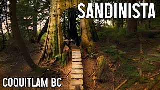
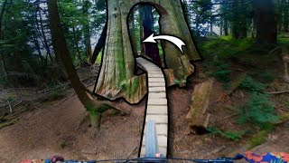
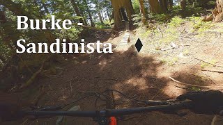
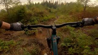
Low angle, loamy and pedally, Sandinista is one of the older trails on the mountain. Some sections are showing their age after many tough winters. The cherry on top is the final feature through an old stump.

This trail is unsanctioned.

Disclaimer

Please avoid when wet.

Trail Supporters

Recent Activity on Trail

Past Week
  • 1 rides
  • 6 miles average
6 Months
  • 9 rides
  • 11 miles avg distance
All
  • 156 rides
  • Last: Jun 11, 2026
c1c2c3c4
January
February
March
April
May
June
July
August
September
October
November
December
update trails status or condition

Sandinista Trail Reports

statusdatedescription
May 6, 2026 @ 1:45pm (America/Vancouver)
May 6, 2026
reporter Last weekend we went up and cleared 3 trees including the 2 from the previous report (thanks for the previous notification) and 1 in the bottom...
Apr 23, 2026 @ 9:05pm (America/Vancouver)
Apr 23, 2026
reporter Two chainsaw sized trees down between trail entrance and connector to triple crown. Did not ride lower half.
Jan 8, 2026 @ 8:15pm (America/Vancouver)
Jan 8, 2026
reporter Probably 50cm of snow at the entrance of the trail. 5 or 6 trees down throughout that you can get over easily enough.
Dec 28, 2025 @ 1:42pm (America/Vancouver)
Dec 28, 2025
Oct 30, 2025 @ 5:38pm (America/Vancouver)
Oct 30, 2025
reporter
Thanks for previous reports. Tree is now cleared.
more »
Status:
on May 6, 2026
Dry
Avg: 3.77 (12 votes)
Your vote: 0

view (1,155)
close
3D
Trail Conditions
  • Unknown
  • Snow Groomed
  • Snow Packed
  • Snow Covered
  • Snow Cover Partial
  • Freeze/thaw Cycle
  • Icy
  • Prevalent Mud
  • Wet
  • Variable
  • Ideal
  • Dry
  • Very Dry
Trail Flow (Ridden Direction)
Trailforks scans users ridelogs to determine the most popular direction each trail is ridden. A good flowing trail network will have most trails flowing in a single direction according to their intension.
The colour categories are based on what percentage of riders are riding a trail in its intended direction.
  • > 96%
  • > 90%
  • > 80%
  • > 70%
  • > 50%
  • < 50%
  • bi-directional trail
  • no data
Trail Last Ridden
Trailforks scans ridelogs to determine the last time a trail was ridden.
  • < 2 days
  • < 1 week
  • < 2 weeks
  • < 1 month
  • < 6 months
  • > 6 months
Trail Ridden Direction
The intended direction a trail should be ridden.
  • Downhill Only
  • Downhill Primary
  • Both Directions
  • Uphill Primary
  • Uphill Only
  • One Direction
Contribute Details
Colors indicate trail is missing specified detail.
  • Description
  • Photos
  • Description & Photos
  • Videos
Trail Popularity ?
Trailforks scans ridelogs to determine which trails are ridden the most in the last 9 months. Trails are compared with nearby trails in the same city region with a possible 25 colour shades. Think of this as a heatmap, more rides = more kinetic energy = warmer colors.
  • most popular
  • popular
  • less popular
  • not popular
ATV/ORV/OHV Filter
Max Vehicle Width
inches
US Cell Coverage
Legend
cell carrier legend

Radar Time
Activity Recordings
Trailforks uses anonymized public activity data. ?
Activity Recordings
Trailforks uses anonymized public activity data. ?
Personal Heatmap
Activity Types
all / none
Options
2
Date range month
Winter Trails
Warning A routing network for winter maps does not exist. Selecting trails using the winter trails layer has been disabled.
Missing Trails
Most Popular
Least Popular
Trails are colored based on popularity. The more popular a trail is, the more red. Less popular trails trend towards green.
Jump Magnitude Heatmap
Heatmap of where riders jump on trails. Zoom in to see individual jumps, click circles to view jump details.
BC Backroad Status

Service Road Atlas is a free to use, community-driven service for viewing and creating reports on the numerous back-country service roads around B.C. and Alberta.

map legend
Slope Aspect
Direction the slope faces
Flat N NE E SE S SW W NW
Trails Deemphasized
Trails are shown in grey.
disable
Only show trails with no bike usage.
Enable
Suggested Layers
Based on selected activity type

    Save the current map location and zoom level as your default home location whenever this page is loaded.

    Save
        Directions to sandinista trailhead (49.322040, -122.729030)

        Photos

        28 more »
        78 |
        May 11, 2023 @ 10:54pm
        May 11, 2023
        351 |
        Jun 12, 2017 @ 10:57pm
        Jun 12, 2017
        214 |
        Jun 12, 2017 @ 10:57pm
        Jun 12, 2017
        201 |
        Jun 12, 2017 @ 10:57pm
        Jun 12, 2017

        Videos

        5 more »
        youtuber Sandinista - Burke Mountain Coquitlam Mountain...
        4:09 | 546 | Sep 12, 2022 , Coquitlam
        youtuber This Trail Goes Straight Through a Tree
        3:57 | 540 | Aug 19, 2021 , Coquitlam
        Burke - Sandinista
        175 | May 16, 2023 , Coquitlam
        Sandinista
        6:00 | 113 | Oct 23, 2022 , Coquitlam

        Routes with this trail

        10 miles 3,116 ft 11 Loop
        Hope you enjoy the Ride. We're gona love it.

        Trail Products

        Reviews / Comments

        No reviews yet, be the first to write a review or ask a question.
        Use trail reports to comment on trail conditions.


        We hope you've been enjoying Trailforks!

        Create a FREE account to view trail comments and much more.

        • #2111 - 3,978 views

        Frequently Asked Questions About Sandinista

        Where is Sandinista located?
        Sandinista is located in Burke Mountain, Coquitlam, British Columbia, Canada. It is part of the Burke Mountain trail network. The trailhead is located at coordinates 49.32204, -122.72903.
        How hard is Sandinista?
        Sandinista is rated as Black Diamond difficulty. The physical rating is Moderate. The average grade is 13.9%. The climb difficulty is rated Green.
        What is the elevation gain for Sandinista?
        The trail has 412 ft of elevation descent. The elevation ranges from 2,129 ft to 2,541 ft.
        Is Sandinista a point to point trail?
        Yes, Sandinista is a point to point trail. The direction is Downhill Only. The trail type is singletrack.

        Hit the Trail

        Open in App

        Get this trail on your phone instantly.
        open trail in app

        Download Trail

        Save to wishlist, Garmin & download.
        save the trail

        Find Related Routes

        Find routes and users activities that include this trail.
        find routes for this trail

        You must enter a description before submitting.