more stats
1,181 ft
Distance
-91 ft
Descent
00:03:15
Avg time
-91 ft
Altitude change
1,072 ft
Altitude min
1,165 ft
Altitude max
1,165 ft
Altitude start
1,073 ft
Altitude end
-7.7%
Grade
-17.1%
Grade max
2.2%
Grade min
16 ft
Distance climb
856 ft
Distance down
308 ft
Distance flat
00:03:15
Avg time

Sandstone Sender Details

  • Activities
    • Mountain Bike
    • E-Bike
    • Hike
    • Trail Running
  • Riding Area
    Platte River State Park
    Louisville, Nebraska
  • Difficulty Rating
  • Local Popularity
    75 in Mountain Biking [+]
    • 90 in E-Biking
    • 5 in Trail Running
    • 65 in Hiking
  • Trail Type
    Singletrack
  • Bike Type
    DH, AM, XC
  • Direction
    Downhill Only
  • Climb Difficulty
    Blue
  • Physical Rating
    Hard
  • Trail Visibility
    Sometimes hard to follow
  • eBike Allowed
    Yes up to Class 1
  • TTFs on Trail
    Berm, Drop, Jump, Gap Jump
  • Year Opened
    2024
  • Land Owner
    Nebraska Game and Parks

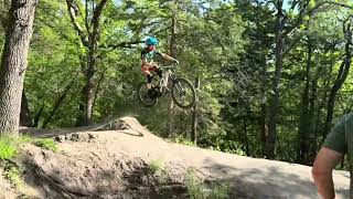
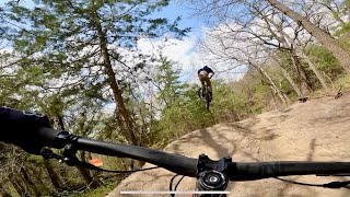
Challenging fast and jump-oriented downhill only trail. Bike-optimized features. Originally built as fall-line trail in 2021, it was re-vamped in 2024 to improve flow and reduce erosion.

Access Info

Pedal up Wild Turkey Trail about 1/2 mile after Decker Creek Bridge. Look for the drop in to the right. It will be a hard right turn.

Disclaimer

Always walk and pre-ride as feature conditions change daily.

Local Trail Association
Traditionally Indigenous Territory

Recent Activity on Trail

Past Week
  • 1 rides
  • 57 miles average
6 Months
  • 33 rides
  • 16 miles avg distance
All
  • 256 rides
  • Last: Jun 14, 2026
c1c2c3c4
January
February
March
April
May
June
July
August
September
October
November
December
update trails status or condition

Sandstone Sender Trail Reports

statusdatedescription
May 26, 2026 @ 5:19pm (America/Chicago)
May 26, 2026
Dirt is good today!!
May 20, 2026 @ 4:37pm (America/Chicago)
May 20, 2026
reporter
Repaired erosion from heavy rains on lower table top
May 18, 2026 @ 1:21pm (America/Chicago)
May 18, 2026
reporter
Repaired landing for the first shark fin & table feature after heavy rains
Apr 27, 2026 @ 5:16pm (America/Chicago)
Apr 27, 2026
reporter
Water was beginning to run through the RGDs on a few downs, restored them and opened up drains to prevent larger erosion lines
Apr 22, 2026 @ 9:46am (America/Chicago)
Apr 22, 2026
It is a bit dusty but dirt is about perfect
more »
Status:
on May 26, 2026
Ideal
Avg: 3.98 (2 votes)
Your vote: 0

view (2,487)
close
3D
Trail Conditions
  • Unknown
  • Snow Groomed
  • Snow Packed
  • Snow Covered
  • Snow Cover Partial
  • Freeze/thaw Cycle
  • Icy
  • Prevalent Mud
  • Wet
  • Variable
  • Ideal
  • Dry
  • Very Dry
Trail Flow (Ridden Direction)
Trailforks scans users ridelogs to determine the most popular direction each trail is ridden. A good flowing trail network will have most trails flowing in a single direction according to their intension.
The colour categories are based on what percentage of riders are riding a trail in its intended direction.
  • > 96%
  • > 90%
  • > 80%
  • > 70%
  • > 50%
  • < 50%
  • bi-directional trail
  • no data
Trail Last Ridden
Trailforks scans ridelogs to determine the last time a trail was ridden.
  • < 2 days
  • < 1 week
  • < 2 weeks
  • < 1 month
  • < 6 months
  • > 6 months
Trail Ridden Direction
The intended direction a trail should be ridden.
  • Downhill Only
  • Downhill Primary
  • Both Directions
  • Uphill Primary
  • Uphill Only
  • One Direction
Contribute Details
Colors indicate trail is missing specified detail.
  • Description
  • Photos
  • Description & Photos
  • Videos
Trail Popularity ?
Trailforks scans ridelogs to determine which trails are ridden the most in the last 9 months. Trails are compared with nearby trails in the same city region with a possible 25 colour shades. Think of this as a heatmap, more rides = more kinetic energy = warmer colors.
  • most popular
  • popular
  • less popular
  • not popular
ATV/ORV/OHV Filter
Max Vehicle Width
inches
US Cell Coverage
Legend
cell carrier legend

Radar Time
Activity Recordings
Trailforks uses anonymized public activity data. ?
Activity Recordings
Trailforks uses anonymized public activity data. ?
Personal Heatmap
Activity Types
all / none
Options
2
Date range month
Winter Trails
Warning A routing network for winter maps does not exist. Selecting trails using the winter trails layer has been disabled.
Missing Trails
Most Popular
Least Popular
Trails are colored based on popularity. The more popular a trail is, the more red. Less popular trails trend towards green.
Jump Magnitude Heatmap
Heatmap of where riders jump on trails. Zoom in to see individual jumps, click circles to view jump details.
BC Backroad Status

Service Road Atlas is a free to use, community-driven service for viewing and creating reports on the numerous back-country service roads around B.C. and Alberta.

map legend
Slope Aspect
Direction the slope faces
Flat N NE E SE S SW W NW
Trails Deemphasized
Trails are shown in grey.
disable
Only show trails with no bike usage.
Enable
Suggested Layers
Based on selected activity type

    Save the current map location and zoom level as your default home location whenever this page is loaded.

    Save
        Directions to sandstone-sender trailhead (40.992620, -96.200880)

        Photos

        0 more »
        21 |
        May 20, 2026 @ 2:44pm
        May 20, 2026
        19 |
        May 20, 2026 @ 2:40pm
        May 20, 2026
        18 |
        May 20, 2026 @ 2:40pm
        May 20, 2026
        16 |
        May 20, 2026 @ 2:39pm
        May 20, 2026

        Videos

        2 more »
        Sandstone Sender
        3:34 | 26 | Apr 6, 2026 , Louisville
        Sandstone Sender PoV | Platte River SP
        0:13 | 80 | May 4, 2025 , Louisville

        Reviews / Comments

        No reviews yet, be the first to write a review or ask a question.
        Use trail reports to comment on trail conditions.


        We hope you've been enjoying Trailforks!

        Create a FREE account to view trail comments and much more.

        • By Omaha-MTNBKRTF Pro & contributors
        • #465398 - 950 views

        Frequently Asked Questions About Sandstone Sender

        Where is Sandstone Sender located?
        Sandstone Sender is located in Platte River State Park, Louisville, Nebraska, United States. It is part of the Platte River State Park trail network. The trailhead is located at coordinates 40.99262, -96.20088.
        How hard is Sandstone Sender?
        Sandstone Sender is rated as Black Diamond difficulty. The physical rating is Hard. The average grade is 7.7%. The climb difficulty is rated Blue.
        What is the elevation gain for Sandstone Sender?
        The trail has 91 ft of elevation descent. The elevation ranges from 1,072 ft to 1,165 ft.
        Is Sandstone Sender a point to point trail?
        Yes, Sandstone Sender is a point to point trail. The direction is Downhill Only. The trail type is singletrack.

        Hit the Trail

        Open in App

        Get this trail on your phone instantly.
        open trail in app

        Download Trail

        Save to wishlist, Garmin & download.
        save the trail

        Find Related Routes

        Find routes and users activities that include this trail.
        find routes for this trail

        You must enter a description before submitting.