more stats
1.4 miles
Distance
705 ft
Climb
-21 ft
Descent
00:24:15
Avg time
684 ft
Altitude change
5,523 ft
Altitude min
6,206 ft
Altitude max
5,523 ft
Altitude start
6,206 ft
Altitude end
9.285%
Grade
-12.98%
Grade max
27.488%
Grade min
1 mile
Distance climb
460 ft
Distance down
328 ft
Distance flat
00:24:15
Avg time

Sawmill Details

  • Activities
    • Mountain Bike
    • Hike
    • Trail Running
  • Riding Area
    Horsetooth Mountain
    Fort Collins, Colorado
  • Difficulty Rating
  • Voted Difficulty
    Black Diamond (4 votes)
  • Local Popularity
    85 in Mountain Biking [+]
    • 65 in Trail Running
    • 60 in Hiking
  • Global Ranking
    #35747 in Mountain Biking [+]
    • #72510 in Trail Running
    • #72740 in Hiking
  • Trail Type
    Singletrack
  • Direction
    Both Directions
    Popular In Reverse
  • Climb Difficulty
    Blue
  • Physical Rating
    Hard
  • Dogs Allowed
    Yes
  • TTFs on Trail
    Drop, Rock Garden

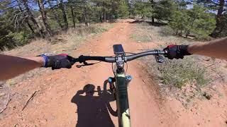
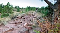
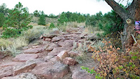
Fast & rough trail with several small, technical rock gardens. Top half has some sections where you can double over obstacles at speed. On the bottom half there is a stair-step rock feature and some tight switchbacks.

Local Trail Association

Recent Activity on Trail

Past Week
  • 0 rides
  •  
6 Months
  • 30 rides
  • 14 miles avg distance
All
  • 299 rides
  • Last: Jun 11, 2026
c1c2c3c4
January
February
March
April
May
June
July
August
September
October
November
December
update trails status or condition

Sawmill Trail Reports

Status:
on Sep 22, 2024
Ideal
Avg: 4.22 (22 votes)
Your vote: 0

view (2,462)
close
3D
Trail Conditions
  • Unknown
  • Snow Groomed
  • Snow Packed
  • Snow Covered
  • Snow Cover Partial
  • Freeze/thaw Cycle
  • Icy
  • Prevalent Mud
  • Wet
  • Variable
  • Ideal
  • Dry
  • Very Dry
Trail Flow (Ridden Direction)
Trailforks scans users ridelogs to determine the most popular direction each trail is ridden. A good flowing trail network will have most trails flowing in a single direction according to their intension.
The colour categories are based on what percentage of riders are riding a trail in its intended direction.
  • > 96%
  • > 90%
  • > 80%
  • > 70%
  • > 50%
  • < 50%
  • bi-directional trail
  • no data
Trail Last Ridden
Trailforks scans ridelogs to determine the last time a trail was ridden.
  • < 2 days
  • < 1 week
  • < 2 weeks
  • < 1 month
  • < 6 months
  • > 6 months
Trail Ridden Direction
The intended direction a trail should be ridden.
  • Downhill Only
  • Downhill Primary
  • Both Directions
  • Uphill Primary
  • Uphill Only
  • One Direction
Contribute Details
Colors indicate trail is missing specified detail.
  • Description
  • Photos
  • Description & Photos
  • Videos
Trail Popularity ?
Trailforks scans ridelogs to determine which trails are ridden the most in the last 9 months. Trails are compared with nearby trails in the same city region with a possible 25 colour shades. Think of this as a heatmap, more rides = more kinetic energy = warmer colors.
  • most popular
  • popular
  • less popular
  • not popular
ATV/ORV/OHV Filter
Max Vehicle Width
inches
US Cell Coverage
Legend
cell carrier legend

Radar Time
Activity Recordings
Trailforks uses anonymized public activity data. ?
Activity Recordings
Trailforks uses anonymized public activity data. ?
Personal Heatmap
Activity Types
all / none
Options
2
Date range month
Winter Trails
Warning A routing network for winter maps does not exist. Selecting trails using the winter trails layer has been disabled.
Missing Trails
Most Popular
Least Popular
Trails are colored based on popularity. The more popular a trail is, the more red. Less popular trails trend towards green.
Jump Magnitude Heatmap
Heatmap of where riders jump on trails. Zoom in to see individual jumps, click circles to view jump details.
BC Backroad Status

Service Road Atlas is a free to use, community-driven service for viewing and creating reports on the numerous back-country service roads around B.C. and Alberta.

map legend
Slope Aspect
Direction the slope faces
Flat N NE E SE S SW W NW
Trails Deemphasized
Trails are shown in grey.
disable
Only show trails with no bike usage.
Enable
Suggested Layers
Based on selected activity type

    Save the current map location and zoom level as your default home location whenever this page is loaded.

    Save
        Directions to sawmill-13593 trailhead (40.551940, -105.168030)

        Photos

        3 more »
        65 |
        Jul 18, 2025 @ 11:29am
        Jul 18, 2025
        650 |
        Aug 22, 2018 @ 5:42pm
        Aug 22, 2018
        194 |
        Aug 18, 2017 @ 8:46pm
        Aug 18, 2017

        Videos

        4 more »
        Sawmill - Top Section Downhill
        6:21 | 93 | Jun 5, 2025 , Fort Collins
        Sawmill + Skidder Rocks - Horsetooth Mountain...
        6:28 | 154 | Mar 23, 2024 , Fort Collins
        Skidder rocks on Sawmill Trail
        0:07 | | Nov 4, 2023 , Fort Collins
        Skidder rocks on Sawmill
        0:15 | | Nov 4, 2023 , Fort Collins

        Routes with this trail

        5.0 12 miles 2,326 ft 23 Loop
        This loops connects some of the best descending in Horsetooth Mountain Park. The climbs are mostly up...
        8 miles 1,449 ft 8
        Quick eight-Mile ride that takes you up Towers, and gives you a bit of Carey Spring, Loggers, and before...
        9 miles 1,773 ft 22 Loop
        Crosscountry loop in HTMP taking in some techy climbing. This loop rolls out for a warmup across before...

        Trail Products

        8 Reviews & Comments


        We hope you've been enjoying Trailforks!

        Create a FREE account to view trail comments and much more.

        • By toddTF Pro Trailforks & contributors
        • #13593 - 3,913 views

        Frequently Asked Questions About Sawmill

        Where is Sawmill located?
        Sawmill is located in Horsetooth Mountain, Fort Collins, Colorado, United States. It is part of the Horsetooth Mountain trail network. The trailhead is located at coordinates 40.55194, -105.16803.
        How hard is Sawmill?
        Sawmill is rated as Blue difficulty. The physical rating is Hard. The average grade is 9.285%. The climb difficulty is rated Blue.
        What is the elevation gain for Sawmill?
        Sawmill has 705 ft of elevation gain. The trail has 21 ft of elevation descent. The elevation ranges from 5,523 ft to 6,206 ft.
        Is Sawmill a point to point trail?
        Sawmill is not a point to point trail. The direction is Both Directions. The trail type is singletrack.

        Hit the Trail

        Open in App

        Get this trail on your phone instantly.
        open trail in app

        Download Trail

        Save to wishlist, Garmin & download.
        save the trail

        Find Related Routes

        Find routes and users activities that include this trail.
        find routes for this trail

        You must enter a description before submitting.