more stats
2.3 miles
Distance
146 ft
Climb
-150 ft
Descent
00:23:37
Avg time
-2 ft
Altitude change
245 ft
Altitude min
320 ft
Altitude max
282 ft
Altitude start
282 ft
Altitude end
-11.7%
Grade max
28.9%
Grade min
3,530 ft
Distance climb
5,049 ft
Distance down
3,471 ft
Distance flat
00:23:37
Avg time

Scar Tree Trail Details

  • Activities
    • Mountain Bike
    • Winter Fat Bike
  • Riding Area
  • AKA
    Red Route
  • Difficulty Rating
  • Voted Difficulty
    Green (1 vote)
  • Local Popularity
    100 in Mountain Biking
  • Global Ranking
    #78010 in Mountain Biking
  • Trail Type
    Singletrack
  • Bike Type
    AM, XC, Fat
  • Direction
    Both Directions
  • Climb Difficulty
    Green
  • Physical Rating
    Moderate
  • Season
    Jan - Dec
  • Dogs Allowed
    Yes
  • eBike Allowed
    Yes up to Class 1
  • TTFs on Trail
    Berm, Drop, Jump
  • Ride in Rain
    Yes
  • Year Opened
    2013
  • Land Owner

Good Points
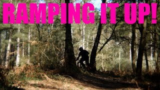
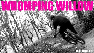
The official trail (Scartree) is short, but well armoured for all weathers and has some decent bermed sections to blast through - it's good for beginners and more experienced riders will still get grins out of it if they hammer round. The rest of Wakerley Great Wood has a fair amount of off-piste trails too if you keep your eyes open for them - if you like tight, twisty, wooded singletrack then there's a fair chance you'll enjoy a ride here.

Bad Points
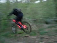
Not much gradient to work with - speed has to come from your legs rather than gravity, and the off-piste trails can be a bit of a lottery in wet weather (the ground is mostly clay-based and turns to slop or thick sticky mud pretty quickly). No real facilities other than a car park (although Fineshades Wood is a 5 minute ride away with a bike shop and cafe).

source: ...

Recent Activity on Trail

Past Week
  • 0 rides
  •  
6 Months
  • 0 rides
  •  
All
  • 22 rides
  • Last: May 7, 2026
c1c2c3c4
January
February
March
April
May
June
July
August
September
October
November
December
update trails status or condition

Scar Tree Trail Trail Reports

statusdatedescription
Dec 13, 2025 @ 11:23am (Europe/London)
Dec 13, 2025
Riding well. A few spots of standing water but not too much mud yet.
Aug 13, 2023 @ 1:38am
Aug 13, 2023
Nov 20, 2022 @ 3:57am
Nov 20, 2022
Rode well despite a helping of rain, quite overgrown in some areas but still very enjoyable
Jul 10, 2022 @ 9:01am
Jul 10, 2022
Rode lovely yesterday, very dusty but all in all very enjoyable. Overgrown bushes in some areas but the trail is still usable.
Oct 17, 2021 @ 5:54am
Oct 17, 2021
It had rained that morning so the single tracks were a bit slippery and recent work by the Forestry Commission had ploughed up places on the...
more »
Status:
on Dec 13, 2025
Variable
Avg: 3.49 (8 votes)
Your vote: 0

view (950)
close
3D
Trail Conditions
  • Unknown
  • Snow Groomed
  • Snow Packed
  • Snow Covered
  • Snow Cover Partial
  • Freeze/thaw Cycle
  • Icy
  • Prevalent Mud
  • Wet
  • Variable
  • Ideal
  • Dry
  • Very Dry
Trail Flow (Ridden Direction)
Trailforks scans users ridelogs to determine the most popular direction each trail is ridden. A good flowing trail network will have most trails flowing in a single direction according to their intension.
The colour categories are based on what percentage of riders are riding a trail in its intended direction.
  • > 96%
  • > 90%
  • > 80%
  • > 70%
  • > 50%
  • < 50%
  • bi-directional trail
  • no data
Trail Last Ridden
Trailforks scans ridelogs to determine the last time a trail was ridden.
  • < 2 days
  • < 1 week
  • < 2 weeks
  • < 1 month
  • < 6 months
  • > 6 months
Trail Ridden Direction
The intended direction a trail should be ridden.
  • Downhill Only
  • Downhill Primary
  • Both Directions
  • Uphill Primary
  • Uphill Only
  • One Direction
Contribute Details
Colors indicate trail is missing specified detail.
  • Description
  • Photos
  • Description & Photos
  • Videos
Trail Popularity ?
Trailforks scans ridelogs to determine which trails are ridden the most in the last 9 months. Trails are compared with nearby trails in the same city region with a possible 25 colour shades. Think of this as a heatmap, more rides = more kinetic energy = warmer colors.
  • most popular
  • popular
  • less popular
  • not popular
ATV/ORV/OHV Filter
Max Vehicle Width
inches
US Cell Coverage
Legend
cell carrier legend

Radar Time
Activity Recordings
Trailforks uses anonymized public activity data. ?
Activity Recordings
Trailforks uses anonymized public activity data. ?
Personal Heatmap
Activity Types
all / none
Options
2
Date range month
Winter Trails
Warning A routing network for winter maps does not exist. Selecting trails using the winter trails layer has been disabled.
Missing Trails
Most Popular
Least Popular
Trails are colored based on popularity. The more popular a trail is, the more red. Less popular trails trend towards green.
Jump Magnitude Heatmap
Heatmap of where riders jump on trails. Zoom in to see individual jumps, click circles to view jump details.
BC Backroad Status

Service Road Atlas is a free to use, community-driven service for viewing and creating reports on the numerous back-country service roads around B.C. and Alberta.

map legend
Slope Aspect
Direction the slope faces
Flat N NE E SE S SW W NW
Trails Deemphasized
Trails are shown in grey.
disable
Only show trails with no bike usage.
Enable
Suggested Layers
Based on selected activity type

    Save the current map location and zoom level as your default home location whenever this page is loaded.

    Save
        Directions to scar-tree-trail trailhead (52.575901, -0.582627)

        Photos

        52 more »
        44 |
        Jun 2, 2025 @ 12:54pm
        Jun 2, 2025
        34 |
        Jun 2, 2025 @ 12:54pm
        Jun 2, 2025
        38 |
        Jun 2, 2025 @ 12:54pm
        Jun 2, 2025
        29 |
        Jun 2, 2025 @ 12:54pm
        Jun 2, 2025

        Videos

        10 more »
        Ramping It Up!
        0:14 | 86 | Jun 2, 2025 , Corby
        Trail Portrait. Whomping Willow.
        0:55 | 55 | Jun 2, 2025 , Corby
        The Wakerley Witch Project
        2:19 | 651 | Jun 2, 2018 , Corby
        Wakerley Great Wood / 16-04-2014 / Trying out...
        0:26 | 2026 | Jun 2, 2018 , Corby

        1 Review & Comments


        We hope you've been enjoying Trailforks!

        Create a FREE account to view trail comments and much more.

        • By rrrooobbbppp & contributors
        • #24164 - 9,371 views

        Frequently Asked Questions About Scar Tree Trail

        Where is Scar Tree Trail located?
        Scar Tree Trail is located in Wakerley Woods, Corby, United Kingdom. It is part of the Wakerley Woods trail network. The trailhead is located at coordinates 52.5759, -0.58263.
        How hard is Scar Tree Trail?
        Scar Tree Trail is rated as Red difficulty. The physical rating is Moderate. The climb difficulty is rated Green.
        What is the elevation gain for Scar Tree Trail?
        Scar Tree Trail has 146 ft of elevation gain. The trail has 150 ft of elevation descent. The elevation ranges from 245 ft to 320 ft.
        Is Scar Tree Trail a point to point trail?
        Scar Tree Trail is not a point to point trail. The direction is Both Directions. The trail type is singletrack.

        Hit the Trail

        Open in App

        Get this trail on your phone instantly.
        open trail in app

        Download Trail

        Save to wishlist, Garmin & download.
        save the trail

        Find Related Routes

        Find routes and users activities that include this trail.
        find routes for this trail

        You must enter a description before submitting.