
Open in App
Get this trail on your phone instantly.

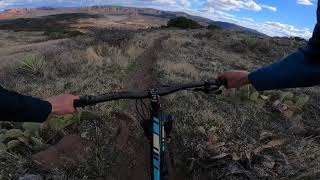
Intermediate 50% and advanced 50%, 2.18 mile MTB trail which is a bi-directional singletrack that is an up, up and over trail with some very technical steep sections at both ends of the trail. The trail tread is mostly on packed bentonite clay and during wet periods it is not the place to be. The views from this trail are spectacular, but as a single trail that goes nowhere it is not popular as it could be if linked up with something more rideable to eliminate the impossible climb sections at either end. There is no preferred direction unless you might want to ride Lime Kiln to Cottonwood.
| c1 | c2 | c3 | c4 |
|---|---|---|---|
January | February | March | April |
May | June | July | August |
September | October | November | December |

Service Road Atlas is a free to use, community-driven service for viewing and creating reports on the numerous back-country service roads around B.C. and Alberta.
Save the current map location and zoom level as your default home location whenever this page is loaded.
SaveWe hope you've been enjoying Trailforks!
Create a FREE account to view trail comments and much more.
You must enter a description before submitting.

