more stats
4,551 ft
Distance
-1,024 ft
Descent
00:06:56
Avg time
-1,024 ft
Altitude change
3,411 ft
Altitude min
4,436 ft
Altitude max
4,436 ft
Altitude start
3,412 ft
Altitude end
-22.5%
Grade
-80.8%
Grade max
-5.3%
Grade min
4,551 ft
Distance down
00:06:56
Avg time

Schistaule Upper Details

  • Activities
    • Mountain Bike
    • E-Bike
    • Hike
    • Trail Running
  • Riding Area
    Saint-Lary Enduro
    Saint Lary Soulan
  • Difficulty Rating
  • Voted Difficulty
    Blue (1 vote)
  • Local Popularity
    100 in Mountain Biking [+]
    • 95 in E-Biking
    • 5 in Trail Running
    • 5 in Hiking
  • Global Ranking
    #40101 in Mountain Biking [+]
    • #24313 in E-Biking
    • #130487 in Trail Running
    • #123580 in Hiking
  • Trail Type
    Singletrack
  • Bike Type
    AM
  • Direction
    Downhill Primary
    Popular Direction Shown
  • Physical Rating
    Moderate
  • Trail Visibility
    Always easy to follow
  • Season
    "march - nov"
  • Alpine Trail
    Yes
  • Dogs Allowed
    Yes
  • eBike Allowed
    Yes up to Class 1
  • TTFs on Trail
    Berm, Jump, Rock Face, Rock Garden
  • Year Opened
    2017
  • Land Owner

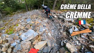
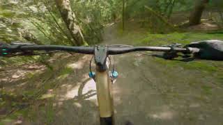
Piste très technique au cœur d'une forêt variée, mono trace allant jusqu'à 45% de pente. Elle possède un flow continue de haut en bas et à été travaillée pour garantir votre plaisir et votre sécurité.
Very technical track in the heart of a varied forest, single track up to 45% slope. It has a continuous flow from top to bottom and has been worked to guarantee your pleasure and your safety.
Pista muy técnica en el corazón de un bosque variado, pista única hasta un 45% de pendiente. Tiene un flujo continuo de arriba a abajo y se ha trabajado para garantizar su placer y su seguridad.

Access Info

Accès depuis le parking sud de Saint Lary balisage FFC monté en vélo ou en voiture par une route jusqu'au village d'Ens.
Access from the car park south of Saint Lary beacon FFC mounted by bike or car by a road to the village of Ens.
Acceso desde el aparcamiento al sur de Saint Lary balizamiento FFC montado en bicicleta o en coche por un camino hacia el pueblo de Ens.

Recent Activity on Trail

Past Week
  • 1 rides
  • 5 miles average
6 Months
  • 12 rides
  • 16 miles avg distance
All
  • 77 rides
  • Last: Jun 13, 2026
c1c2c3c4
January
February
March
April
May
June
July
August
September
October
November
December
Status:
on Jun 3, 2026
Dry
Avg: 4.63 (15 votes)
Your vote: 0

view (557)
close
3D
Trail Conditions
  • Unknown
  • Snow Groomed
  • Snow Packed
  • Snow Covered
  • Snow Cover Partial
  • Freeze/thaw Cycle
  • Icy
  • Prevalent Mud
  • Wet
  • Variable
  • Ideal
  • Dry
  • Very Dry
Trail Flow (Ridden Direction)
Trailforks scans users ridelogs to determine the most popular direction each trail is ridden. A good flowing trail network will have most trails flowing in a single direction according to their intension.
The colour categories are based on what percentage of riders are riding a trail in its intended direction.
  • > 96%
  • > 90%
  • > 80%
  • > 70%
  • > 50%
  • < 50%
  • bi-directional trail
  • no data
Trail Last Ridden
Trailforks scans ridelogs to determine the last time a trail was ridden.
  • < 2 days
  • < 1 week
  • < 2 weeks
  • < 1 month
  • < 6 months
  • > 6 months
Trail Ridden Direction
The intended direction a trail should be ridden.
  • Downhill Only
  • Downhill Primary
  • Both Directions
  • Uphill Primary
  • Uphill Only
  • One Direction
Contribute Details
Colors indicate trail is missing specified detail.
  • Description
  • Photos
  • Description & Photos
  • Videos
Trail Popularity ?
Trailforks scans ridelogs to determine which trails are ridden the most in the last 9 months. Trails are compared with nearby trails in the same city region with a possible 25 colour shades. Think of this as a heatmap, more rides = more kinetic energy = warmer colors.
  • most popular
  • popular
  • less popular
  • not popular
ATV/ORV/OHV Filter
Max Vehicle Width
inches
US Cell Coverage
Legend
cell carrier legend

Radar Time
Activity Recordings
Trailforks uses anonymized public activity data. ?
Activity Recordings
Trailforks uses anonymized public activity data. ?
Personal Heatmap
Activity Types
all / none
Options
2
Date range month
Winter Trails
Warning A routing network for winter maps does not exist. Selecting trails using the winter trails layer has been disabled.
Missing Trails
Most Popular
Least Popular
Trails are colored based on popularity. The more popular a trail is, the more red. Less popular trails trend towards green.
Jump Magnitude Heatmap
Heatmap of where riders jump on trails. Zoom in to see individual jumps, click circles to view jump details.
BC Backroad Status

Service Road Atlas is a free to use, community-driven service for viewing and creating reports on the numerous back-country service roads around B.C. and Alberta.

map legend
Slope Aspect
Direction the slope faces
Flat N NE E SE S SW W NW
Trails Deemphasized
Trails are shown in grey.
disable
Only show trails with no bike usage.
Enable
Suggested Layers
Based on selected activity type

    Save the current map location and zoom level as your default home location whenever this page is loaded.

    Save
        Directions to schistaule-upper trailhead (42.804570, 0.326680)

        Photos

        10 more »
        109 |
        Nov 29, 2018 @ 10:44am
        Nov 29, 2018
        110 |
        Oct 27, 2018 @ 1:39pm
        Oct 27, 2018
        158 |
        Oct 27, 2018 @ 1:38pm
        Oct 27, 2018
        128 |
        Oct 27, 2018 @ 1:38pm
        Oct 27, 2018

        Videos

        5 more »
        DESCUBRIMOS ESTE PARAISO CICLISTA EN FRANCIA ...
        9:25 | 69 | Mar 26, 2026 , Saint Lary Soulan
        Saint Lary - MTB - Pyrenees - Schistaule trail...
        10:33 | 134 | Jul 10, 2024 , Saint Lary Soulan
        TRANKILMONT avec des types sur
        6:32 | 375 | Sep 29, 2019 , Saint Lary Soulan
        POV Trankilmont La Schistaule
        8:48 | 488 | Apr 15, 2019 , Saint Lary Soulan

        7 Reviews & Comments


        We hope you've been enjoying Trailforks!

        Create a FREE account to view trail comments and much more.

        • By stephML & contributors
        • #151836 - 2,300 views

        Frequently Asked Questions About Schistaule Upper

        Where is Schistaule Upper located?
        Schistaule Upper is located in Saint-Lary Enduro, Saint Lary Soulan, France. It is part of the Saint-Lary Enduro trail network. The trailhead is located at coordinates 42.80457, 0.32668.
        How hard is Schistaule Upper?
        Schistaule Upper is rated as Red difficulty. The physical rating is Moderate. The average grade is 22.5%.
        What is the elevation gain for Schistaule Upper?
        The trail has 1,024 ft of elevation descent. The elevation ranges from 3,411 ft to 4,436 ft.
        Is Schistaule Upper a point to point trail?
        Schistaule Upper is not a point to point trail. The direction is Downhill Primary. The trail type is singletrack.

        Hit the Trail

        Open in App

        Get this trail on your phone instantly.
        open trail in app

        Download Trail

        Save to wishlist, Garmin & download.
        save the trail

        Find Related Routes

        Find routes and users activities that include this trail.
        find routes for this trail

        You must enter a description before submitting.