more stats
3.1 miles
Distance
36 ft
Climb
-963 ft
Descent
00:30:32
Avg time
-925 ft
Altitude change
8,657 ft
Altitude min
9,583 ft
Altitude max
9,583 ft
Altitude start
8,658 ft
Altitude end
-5.6%
Grade
-33.7%
Grade max
9.3%
Grade min
1,637 ft
Distance climb
2 miles
Distance down
1,575 ft
Distance flat
00:30:32
Avg time

Schoolbus Details

  • Activities
    • Mountain Bike
    • Hike
    • Trail Running
  • Riding Area
    Magnolia
    Nederland, Colorado
  • AKA
    Bus 'n Shack
  • Difficulty Rating
  • Voted Difficulty
    Blue (7 votes)
  • Local Popularity
    100 in Mountain Biking [+]
    • 80 in Trail Running
    • 70 in Hiking
  • Global Ranking
    #25458 in Mountain Biking [+]
    • #48628 in Trail Running
    • #50319 in Hiking
  • Trail Type
    Singletrack
  • Direction
    Downhill Primary
  • Climb Difficulty
    Black Diamond
  • Physical Rating
    Moderate
  • Trail Visibility
    Sometimes hard to follow
  • Season
    June-Nov
  • Dogs Allowed
    Yes
  • eBike Allowed
  • Land Owner
    USFS

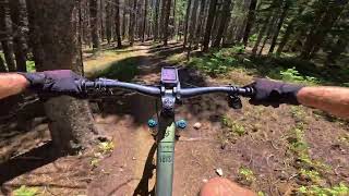
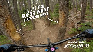
This is currently the flagship trail in the Magnolia Trail system. Please access the top of this trail from Roots and Rocks or one of the several road crossings. Speeds are high descending and sight lines can be very short. I would describe this trail more as a blue/black rather than black but since that's not an option black is more appropriate. Starting from the "toilet bowl" (an old mine pit) on the 503 road at the top of the trail will give you the full downhill experience. The first mile or so is fast and fun with high speed corners and rutted rooty sections. When you get to the open field head down a double track to your right. Keep your eyes peeled on the left for a tight left turn a few hundred yards down (don't miss it or you'll end up in Rollinsville). Split the trees and gear down for a short steep climb to the top of the next fun descent. A small aspen section marks the beginning of a fun descent through mine pits, roots, rocks and loose fast corners. Continue your descent until you come to a couple of switchbacks (first one is armored and second is dirt berm). If you're looking for the bus, it's gone. People used to wonder how someone got it that far into the woods - now you can wonder how they got it out. Aliens? Continue downhill into the section that parallels the drainage and keep your head up for riders coming up the trail as this section has very limited sight lines and is why the suggested direction is downhill only. Keep descending and you will connect with Hobbit 3.

Access Info

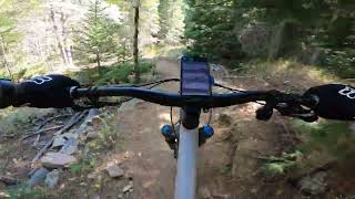
Roots and Rocks Trail from the top of Hobbit 3. Take a right when you hit the gravel road and continue up the road to the toilet bowl (old mine pit).

This trail is unsanctioned.

Trail Supporters
Traditionally Indigenous Territory

Recent Activity on Trail

Past Week
  • 7 rides
  • 19 miles average
6 Months
  • 26 rides
  • 15 miles avg distance
All
  • 394 rides
  • Last: Jun 17, 2026
c1c2c3c4
January
February
March
April
May
June
July
August
September
October
November
December
update trails status or condition

Schoolbus Trail Reports

statusdatedescription
Oct 17, 2024 @ 11:03am
Oct 17, 2024
Aug 10, 2024 @ 12:49am
Aug 10, 2024
Aug 2, 2024 @ 4:09am
Aug 2, 2024
Still a downed tree near the bottom of the trail.
Jul 28, 2024 @ 11:00am
Jul 28, 2024
Downed tree near the bottom, the top is chest high and in part of the trail.
Jun 25, 2024 @ 10:07am
Jun 25, 2024
more »
Status:
on Oct 17, 2024
Ideal
Avg: 3.69 (23 votes)
Your vote: 0

view (2,497)
close
3D
Trail Conditions
  • Unknown
  • Snow Groomed
  • Snow Packed
  • Snow Covered
  • Snow Cover Partial
  • Freeze/thaw Cycle
  • Icy
  • Prevalent Mud
  • Wet
  • Variable
  • Ideal
  • Dry
  • Very Dry
Trail Flow (Ridden Direction)
Trailforks scans users ridelogs to determine the most popular direction each trail is ridden. A good flowing trail network will have most trails flowing in a single direction according to their intension.
The colour categories are based on what percentage of riders are riding a trail in its intended direction.
  • > 96%
  • > 90%
  • > 80%
  • > 70%
  • > 50%
  • < 50%
  • bi-directional trail
  • no data
Trail Last Ridden
Trailforks scans ridelogs to determine the last time a trail was ridden.
  • < 2 days
  • < 1 week
  • < 2 weeks
  • < 1 month
  • < 6 months
  • > 6 months
Trail Ridden Direction
The intended direction a trail should be ridden.
  • Downhill Only
  • Downhill Primary
  • Both Directions
  • Uphill Primary
  • Uphill Only
  • One Direction
Contribute Details
Colors indicate trail is missing specified detail.
  • Description
  • Photos
  • Description & Photos
  • Videos
Trail Popularity ?
Trailforks scans ridelogs to determine which trails are ridden the most in the last 9 months. Trails are compared with nearby trails in the same city region with a possible 25 colour shades. Think of this as a heatmap, more rides = more kinetic energy = warmer colors.
  • most popular
  • popular
  • less popular
  • not popular
ATV/ORV/OHV Filter
Max Vehicle Width
inches
US Cell Coverage
Legend
cell carrier legend

Radar Time
Activity Recordings
Trailforks uses anonymized public activity data. ?
Activity Recordings
Trailforks uses anonymized public activity data. ?
Personal Heatmap
Activity Types
all / none
Options
2
Date range month
Winter Trails
Warning A routing network for winter maps does not exist. Selecting trails using the winter trails layer has been disabled.
Missing Trails
Most Popular
Least Popular
Trails are colored based on popularity. The more popular a trail is, the more red. Less popular trails trend towards green.
Jump Magnitude Heatmap
Heatmap of where riders jump on trails. Zoom in to see individual jumps, click circles to view jump details.
BC Backroad Status

Service Road Atlas is a free to use, community-driven service for viewing and creating reports on the numerous back-country service roads around B.C. and Alberta.

map legend
Slope Aspect
Direction the slope faces
Flat N NE E SE S SW W NW
Trails Deemphasized
Trails are shown in grey.
disable
Only show trails with no bike usage.
Enable
Suggested Layers
Based on selected activity type

    Save the current map location and zoom level as your default home location whenever this page is loaded.

    Save
        Directions to schoolbus trailhead (39.926370, -105.549570)

        Photos

        9 more »
        67 |
        Jun 27, 2025 @ 5:22am
        Jun 27, 2025
        416 |
        May 31, 2020 @ 3:44pm
        May 31, 2020
        296 |
        Sep 22, 2019 @ 8:10am
        Sep 22, 2019
        406 |
        Jul 11, 2019 @ 3:38pm
        Jul 11, 2019

        Videos

        4 more »
        Schoolbus
        21:11 | 99 | Aug 27, 2025 , Nederland
        Punching Trees in Nederland
        8:08 | 361 | Nov 22, 2022 , Nederland
        Schoolbus - West Magnolia - Nederland - Colorado
        3:26 | 223 | Sep 29, 2022 , Nederland
        Schoolbus trail - Nederland, CO
        24:19 | 1127 | Jun 23, 2018 , Nederland

        Routes with this trail

        2.5 17 miles 2,260 ft 10 Out & Back
        Ride from West Mag to Eldora and back! Getting to Kinglet is a ride in and of itself with the closest...
        12 miles 1,649 ft 9 Out & Back
        Ride from West Mag to Eldora and back! Getting to Kinglet is a ride in and of itself with the closest...
        2.7 12 miles 1,603 ft 6 Loop
        Here's an updated version of the West Mag Backcountry Ride from the main center parking lot and newer...

        15 Reviews & Comments


        We hope you've been enjoying Trailforks!

        Create a FREE account to view trail comments and much more.

        • #13753 - 8,054 views

        Frequently Asked Questions About Schoolbus

        Where is Schoolbus located?
        Schoolbus is located in Magnolia, Nederland, Colorado, United States. It is part of the Magnolia trail network. The trailhead is located at coordinates 39.92637, -105.54957.
        How hard is Schoolbus?
        Schoolbus is rated as Black Diamond difficulty. The physical rating is Moderate. The average grade is 5.6%. The climb difficulty is rated Black Diamond.
        What is the elevation gain for Schoolbus?
        Schoolbus has 36 ft of elevation gain. The trail has 963 ft of elevation descent. The elevation ranges from 8,657 ft to 9,583 ft.
        Is Schoolbus a point to point trail?
        Schoolbus is not a point to point trail. The direction is Downhill Primary. The trail type is singletrack.

        Hit the Trail

        Open in App

        Get this trail on your phone instantly.
        open trail in app

        Download Trail

        Save to wishlist, Garmin & download.
        save the trail

        Find Related Routes

        Find routes and users activities that include this trail.
        find routes for this trail

        You must enter a description before submitting.