more stats
2.4 miles
Distance
43 ft
Climb
-2,780 ft
Descent
01:11:47
Avg time
-2,739 ft
Altitude change
2,485 ft
Altitude min
5,227 ft
Altitude max
5,224 ft
Altitude start
2,487 ft
Altitude end
-21.3%
Grade
-101.9%
Grade max
19%
Grade min
604 ft
Distance climb
2 miles
Distance down
469 ft
Distance flat
01:11:47
Avg time

Scoggione Details

  • Activities
    • Mountain Bike
    • E-Bike
    • Hike
    • Trail Running
  • Riding Area
    Monte Legnone
    Colico
  • Difficulty Rating
  • Local Popularity
    50 in Mountain Biking [+]
    • 75 in E-Biking
    • 5 in Trail Running
    • 95 in Hiking
  • Global Ranking
    #27785 in Mountain Biking [+]
    • #57289 in E-Biking
    • #150285 in Trail Running
    • #7116 in Hiking
  • Hiking SAC Scale
    T2 Mountain Hiking
  • Trail Type
    Primitive
  • Bike Type
    DH, AM
  • Direction
    Downhill Primary
    Popular Direction Shown
  • Climb Difficulty
    Double Black Diamond
  • Physical Rating
    Hard
  • Alpine Trail
    Yes
  • TTFs on Trail
    Berm, Drop, Rock Face, Rock Garden, Skinny, Other

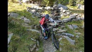
Discesa dal Rifugio Scoggione verso Colico.
Sentiero a tratti molto tecnico ed impegnativo.
Tutto completamente nel bosco sopra l'Alpe Prato e Rusico.

Access Info

Rifugio Scoggione 1575m

Disclaimer

Ride at your own risk, be careful to pedestrians!

Recent Activity on Trail

Past Week
  • 0 rides
  •  
6 Months
  • 0 rides
  •  
All
  • 3 rides
  • Last: Nov 9, 2025
c1c2c3c4
January
February
March
April
May
June
July
August
September
October
November
December
update trails status or condition

Scoggione Trail Reports

statusdatedescription
Jul 15, 2025 @ 8:36am
Jul 15, 2025
Difficult for a black
Jun 20, 2025 @ 7:09am
Jun 20, 2025
Fino a quota 1230 è difficile stare in sella, poi cambia radicalmente e finalmente ci si diverte.
more »
Status:
on Jul 15, 2025
Ideal
Avg: 4.24 (2 votes)
Your vote: 0

view (42)
close
3D
Trail Conditions
  • Unknown
  • Snow Groomed
  • Snow Packed
  • Snow Covered
  • Snow Cover Partial
  • Freeze/thaw Cycle
  • Icy
  • Prevalent Mud
  • Wet
  • Variable
  • Ideal
  • Dry
  • Very Dry
Trail Flow (Ridden Direction)
Trailforks scans users ridelogs to determine the most popular direction each trail is ridden. A good flowing trail network will have most trails flowing in a single direction according to their intension.
The colour categories are based on what percentage of riders are riding a trail in its intended direction.
  • > 96%
  • > 90%
  • > 80%
  • > 70%
  • > 50%
  • < 50%
  • bi-directional trail
  • no data
Trail Last Ridden
Trailforks scans ridelogs to determine the last time a trail was ridden.
  • < 2 days
  • < 1 week
  • < 2 weeks
  • < 1 month
  • < 6 months
  • > 6 months
Trail Ridden Direction
The intended direction a trail should be ridden.
  • Downhill Only
  • Downhill Primary
  • Both Directions
  • Uphill Primary
  • Uphill Only
  • One Direction
Contribute Details
Colors indicate trail is missing specified detail.
  • Description
  • Photos
  • Description & Photos
  • Videos
Trail Popularity ?
Trailforks scans ridelogs to determine which trails are ridden the most in the last 9 months. Trails are compared with nearby trails in the same city region with a possible 25 colour shades. Think of this as a heatmap, more rides = more kinetic energy = warmer colors.
  • most popular
  • popular
  • less popular
  • not popular
ATV/ORV/OHV Filter
Max Vehicle Width
inches
US Cell Coverage
Legend
cell carrier legend

Radar Time
Activity Recordings
Trailforks uses anonymized public activity data. ?
Activity Recordings
Trailforks uses anonymized public activity data. ?
Personal Heatmap
Activity Types
all / none
Options
2
Date range month
Winter Trails
Warning A routing network for winter maps does not exist. Selecting trails using the winter trails layer has been disabled.
Missing Trails
Most Popular
Least Popular
Trails are colored based on popularity. The more popular a trail is, the more red. Less popular trails trend towards green.
Jump Magnitude Heatmap
Heatmap of where riders jump on trails. Zoom in to see individual jumps, click circles to view jump details.
BC Backroad Status

Service Road Atlas is a free to use, community-driven service for viewing and creating reports on the numerous back-country service roads around B.C. and Alberta.

map legend
Slope Aspect
Direction the slope faces
Flat N NE E SE S SW W NW
Trails Deemphasized
Trails are shown in grey.
disable
Only show trails with no bike usage.
Enable
Suggested Layers
Based on selected activity type

    Save the current map location and zoom level as your default home location whenever this page is loaded.

    Save
        Directions to scoggione trailhead (46.110480, 9.416150)

        Photos

        No photos have been added for Scoggione yet, add a photo.

        Videos

        1 more »
        scoggione sound
        5:03 | 476 | May 12, 2023 , Colico

        Reviews / Comments

        No reviews yet, be the first to write a review or ask a question.
        Use trail reports to comment on trail conditions.


        We hope you've been enjoying Trailforks!

        Create a FREE account to view trail comments and much more.

        • By maooosnowTF Pro NORTHNLINE & contributors
        • #613242 - 887 views

        Frequently Asked Questions About Scoggione

        Where is Scoggione located?
        Scoggione is located in Monte Legnone, Colico, Italy. It is part of the Monte Legnone trail network. The trailhead is located at coordinates 46.11048, 9.41615.
        How hard is Scoggione?
        Scoggione is rated as Black difficulty. The physical rating is Hard. The average grade is 21.3%. The climb difficulty is rated Double Black Diamond.
        What is the elevation gain for Scoggione?
        Scoggione has 43 ft of elevation gain. The trail has 2,780 ft of elevation descent. The elevation ranges from 2,485 ft to 5,227 ft.
        Is Scoggione a point to point trail?
        Scoggione is not a point to point trail. The direction is Downhill Primary. The trail type is primitive.

        Hit the Trail

        Open in App

        Get this trail on your phone instantly.
        open trail in app

        Download Trail

        Save to wishlist, Garmin & download.
        save the trail

        Find Related Routes

        Find routes and users activities that include this trail.
        find routes for this trail

        You must enter a description before submitting.