more stats
2.0 miles
Distance
48 ft
Climb
-476 ft
Descent
00:18:52
Avg time
-428 ft
Altitude change
4,042 ft
Altitude min
4,486 ft
Altitude max
4,470 ft
Altitude start
4,042 ft
Altitude end
-4.1%
Grade
-27%
Grade max
12%
Grade min
1,158 ft
Distance climb
2 miles
Distance down
751 ft
Distance flat
00:18:52
Avg time

Scorpion Details

  • Activities
    • Mountain Bike
    • Hike
    • Trail Running
  • Riding Area
    Schuerman Mountain
    Sedona, Arizona
  • Difficulty Rating
  • Voted Difficulty
    Black Diamond (8 votes)
  • Local Popularity
    90 in Mountain Biking [+]
    • 70 in Trail Running
    • 70 in Hiking
  • Global Ranking
    #2341 in Mountain Biking [+]
    • #20881 in Trail Running
    • #4539 in Hiking
  • Trail Type
    Singletrack
  • Bike Type
    AM
  • Direction
    Downhill Primary
    Popular Direction Shown
  • Climb Difficulty
    Black Diamond
  • Physical Rating
    Hard
  • Season
    Scorpion is one of the most weather friendly trails in Sedona
  • Dogs Allowed
    Yes
  • eBike Allowed
  • TTFs on Trail
    Drop
  • Ride in Rain
    Yes
  • Year Opened
    2016
  • Land Owner
    Forest Service

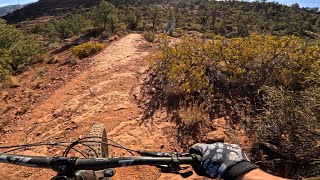
The newly adopted Scorpion trail was previously known as Special Ed,. but when the trail was adopted the FS changed the name to Scorpion which is the mascot of the Red Rock High School, where the trail starts at the north end. In the downhil direction (north to south) the trail is mostly intermediate rated but there are numerous embedded basalt rocks in the trail tread that might be difficult for an intermediated rider to ride at a high speed.

In the downhill direction this trail is going to be one of the most fun trails to ride for advanced and expert riders. There are numerous turns with up and down and turny terrain that will keep riders on their toes. Riders riding downhill at high speeds need to be AWARE that this trail is multi-directional and multi-use, so either hikers or other mountain bikers maybe on the trail traveling in the uphill direction.

Scorpion will be used in the uphill direction as a MAJOR connector trail with the newly adopted Skywalker trail or the old timer Herkenham trail. In the uphill direction the Scorpion trail has short rocky sections that will challenge most intermediate riders and some advanced riders. The newly adopted trail has several re-route sections that mellowed the trail difficulty, so those riders with good climbing skills will have a better chance of climbing the trail without dabbing.

About halfway up the trail riders will come to an intersection of a newly adopted trail called Pyramid. If you are climbing up to Skywalker or Herkenham continue up on Scorpion. For those advanced skilled riders riding downhill you might want to take the Pyramid optional trail to the end of the Scorpion trail.

The Pyramid optional trail gives the advanced skilled rider a 1.2 mile mostly downhill extension with some fairly technical descending sections and technical ledgey up sections that an intermediate rider will most likely end up walking.

At the end of Pyramid you intersect the Scorpion tail where you ride a short section of Scorpion to the dirt parking lot at the Upper Red Rock Loop/Chavez Rd intersection. Hopefully you have a BIG smile on your face at this point.

In the old days there use to be a connector trail called Cakewalk, that trail would take you over to the intersection of Ramshead and Old Post from Scorpion. Both Ramshead and Old Post are important connector trails in the Carroll Canyon area. If you get a chance contact the Red Rock Ranger District and let them know you are interested in them adopting the old Cakewalk trail concept which is being showcased in the current Western Gateway Trails proposal.

Access Info

At the north end the trail is accessed from the Schuerman trailhead. At the south end the trail is accessed from the dirt parking lot at the Upper Red Rock Loop Rd. and Chavez Rd. intersection.

Trail Supporters
Local Trail Association

Recent Activity on Trail

Past Week
  • 0 rides
  •  
6 Months
  • 124 rides
  • 12 miles avg distance
All
  • 1,038 rides
  • Last: May 3, 2025
c1c2c3c4
January
February
March
April
May
June
July
August
September
October
November
December
Status:
on Mar 25, 2026
Ideal
Avg: 3.64 (46 votes)
Your vote: 0

view (6,064)
close
3D
Trail Conditions
  • Unknown
  • Snow Groomed
  • Snow Packed
  • Snow Covered
  • Snow Cover Partial
  • Freeze/thaw Cycle
  • Icy
  • Prevalent Mud
  • Wet
  • Variable
  • Ideal
  • Dry
  • Very Dry
Trail Flow (Ridden Direction)
Trailforks scans users ridelogs to determine the most popular direction each trail is ridden. A good flowing trail network will have most trails flowing in a single direction according to their intension.
The colour categories are based on what percentage of riders are riding a trail in its intended direction.
  • > 96%
  • > 90%
  • > 80%
  • > 70%
  • > 50%
  • < 50%
  • bi-directional trail
  • no data
Trail Last Ridden
Trailforks scans ridelogs to determine the last time a trail was ridden.
  • < 2 days
  • < 1 week
  • < 2 weeks
  • < 1 month
  • < 6 months
  • > 6 months
Trail Ridden Direction
The intended direction a trail should be ridden.
  • Downhill Only
  • Downhill Primary
  • Both Directions
  • Uphill Primary
  • Uphill Only
  • One Direction
Contribute Details
Colors indicate trail is missing specified detail.
  • Description
  • Photos
  • Description & Photos
  • Videos
Trail Popularity ?
Trailforks scans ridelogs to determine which trails are ridden the most in the last 9 months. Trails are compared with nearby trails in the same city region with a possible 25 colour shades. Think of this as a heatmap, more rides = more kinetic energy = warmer colors.
  • most popular
  • popular
  • less popular
  • not popular
ATV/ORV/OHV Filter
Max Vehicle Width
inches
US Cell Coverage
Legend
cell carrier legend

Radar Time
Activity Recordings
Trailforks uses anonymized public activity data. ?
Activity Recordings
Trailforks uses anonymized public activity data. ?
Personal Heatmap
Activity Types
all / none
Options
2
Date range month
Winter Trails
Warning A routing network for winter maps does not exist. Selecting trails using the winter trails layer has been disabled.
Missing Trails
Most Popular
Least Popular
Trails are colored based on popularity. The more popular a trail is, the more red. Less popular trails trend towards green.
Jump Magnitude Heatmap
Heatmap of where riders jump on trails. Zoom in to see individual jumps, click circles to view jump details.
BC Backroad Status

Service Road Atlas is a free to use, community-driven service for viewing and creating reports on the numerous back-country service roads around B.C. and Alberta.

map legend
Slope Aspect
Direction the slope faces
Flat N NE E SE S SW W NW
Trails Deemphasized
Trails are shown in grey.
disable
Only show trails with no bike usage.
Enable
Suggested Layers
Based on selected activity type

    Save the current map location and zoom level as your default home location whenever this page is loaded.

    Save
        Directions to scorpion-48867 trailhead (34.845260, -111.829120)

        Photos

        39 more »
        852 |
        Feb 18, 2016 @ 11:47am
        Feb 18, 2016
        633 |
        Feb 8, 2016 @ 11:55pm
        Feb 8, 2016
        296 |
        Feb 28, 2018 @ 8:05am
        Feb 28, 2018
        461 |
        Feb 9, 2016 @ 9:39pm
        Feb 9, 2016

        Videos

        14 more »
        youtuber Surviving the Sedona Shutdown. Sedona MTB...
        7:11 | 254 | Mar 27, 2023 , Sedona
        youtuber Chasing Light in Sedona
        10:02 | 563 | Apr 5, 2019 , Sedona
        Scorpion Trail – A Great First Ride in Sedona
        7:02 | 105 | Apr 22, 2025 , Sedona
        Sedona MTB | Scorpion - Herkenham
        9:26 | 88 | Jan 22, 2025 , Sedona

        Routes with this trail

        5.0 2 miles 113 ft 4 Loop
        The Scorpion/Pyramid descent is one of the best descents in Sedona. An easier variation of this ride is to...
        5.0 10 miles 1,120 ft 7 Loop
        is a less used trail system in Sedona, but several of the trails make it worth exploring - the Triple- : ,...
        3.0 5 miles 498 ft 2 Loop
        Start this *mostly* downhill shuttled ride by descending some moderate ledges and chunk on . Enjoy the...

        18 Reviews & Comments


        We hope you've been enjoying Trailforks!

        Create a FREE account to view trail comments and much more.

        • By johnf0246TF Pro & contributors
        • #48867 - 11,014 views

        Frequently Asked Questions About Scorpion

        Where is Scorpion located?
        Scorpion is located in Schuerman Mountain, Sedona, Arizona, United States. It is part of the Schuerman Mountain trail network. The trailhead is located at coordinates 34.84526, -111.82912.
        How hard is Scorpion?
        Scorpion is rated as Blue difficulty. The physical rating is Hard. The average grade is 4.1%. The climb difficulty is rated Black Diamond.
        What is the elevation gain for Scorpion?
        Scorpion has 48 ft of elevation gain. The trail has 476 ft of elevation descent. The elevation ranges from 4,042 ft to 4,486 ft.
        Is Scorpion a point to point trail?
        Scorpion is not a point to point trail. The direction is Downhill Primary. The trail type is singletrack.

        Hit the Trail

        Open in App

        Get this trail on your phone instantly.
        open trail in app

        Download Trail

        Save to wishlist, Garmin & download.
        save the trail

        Find Related Routes

        Find routes and users activities that include this trail.
        find routes for this trail

        You must enter a description before submitting.