more stats
1,903 ft
Distance
7 ft
Climb
-189 ft
Descent
00:03:26
Avg time
-182 ft
Altitude change
1,508 ft
Altitude min
1,690 ft
Altitude max
1,690 ft
Altitude start
1,509 ft
Altitude end
-9.6%
Grade
-30.4%
Grade max
6.1%
Grade min
148 ft
Distance climb
1,558 ft
Distance down
197 ft
Distance flat
00:03:26
Avg time

Scorpion Details

  • Activities
    • Mountain Bike
    • E-Bike
  • Riding Area
    Galbraith
    Bellingham, Washington
  • Difficulty Rating
  • Voted Difficulty
    Blue (6 votes)
  • Local Popularity
    75 in Mountain Biking [+]
    • 70 in E-Biking
  • Global Ranking
    #34842 in Mountain Biking [+]
    • #33678 in E-Biking
  • Trail Type
    Singletrack
  • Bike Type
    DH, AM
  • Physical Rating
    Moderate
  • Dogs Allowed
    Yes
  • eBike Allowed
  • TTFs on Trail
    A-Frame, Bridge, Drop, Jump, Rock Face
  • Ride in Rain
    Yes

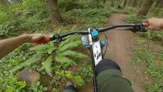
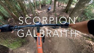
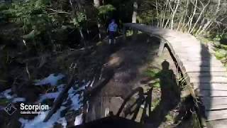
Scorpion is the more difficult route down from the summit of Galbraith. Like Evolution, it sports a mix of ladders, drops, and jumps, but the features on Scorpion are steeper, narrower, and bigger.

The top half carries speed smoothly despite two steep sections. The bottom half is more awkward with enough elevation changes to make a consistent rhythm difficult.

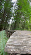
Notable features include the large ladder drop at the start, some tricky ladder-to-log rides, and an optional suspension bridge. Of course there is more to see, including the new spur which is mostly rolling jumps at the moment.

Trail Supporters
Local Trail Association
Traditionally Indigenous Territory

Recent Activity on Trail

Past Week
  • 6 rides
  • 17 miles average
6 Months
  • 98 rides
  • 13 miles avg distance
All
  • 1,023 rides
  • Last: Jun 21, 2026
c1c2c3c4
January
February
March
April
May
June
July
August
September
October
November
December
update trails status or condition

Scorpion Trail Reports

statusdatedescription
May 18, 2026 @ 2:03pm (America/Los_Angeles)
May 18, 2026
reporter Trail inventory rating: 2 A few significant draining problems persist, even with the mostly dry trail otherwise. Lots of branches on trail at...
Apr 28, 2026 @ 11:56am (America/Los_Angeles)
Apr 28, 2026
reporter
Tree is cleared.
Apr 23, 2026 @ 1:11pm (America/Vancouver)
Apr 23, 2026
Subpar (2) - That big tree needs to be taken out. There is a ride around but there are lots pokey branches. Need a big chain saw for this one.
Mar 31, 2026 @ 9:28am (America/Vancouver)
Mar 31, 2026
24” tree trunk laying on side of trail after first trail split to the right. Able to ride around an end....
Mar 19, 2026 @ 4:54pm (America/Los_Angeles)
Mar 19, 2026
Large tree down across trail, blocking trail
more »
Status:
on May 18, 2026
Ideal
Avg: 3.71 (43 votes)
Your vote: 0

view (5,134)
close
3D
Trail Conditions
  • Unknown
  • Snow Groomed
  • Snow Packed
  • Snow Covered
  • Snow Cover Partial
  • Freeze/thaw Cycle
  • Icy
  • Prevalent Mud
  • Wet
  • Variable
  • Ideal
  • Dry
  • Very Dry
Trail Flow (Ridden Direction)
Trailforks scans users ridelogs to determine the most popular direction each trail is ridden. A good flowing trail network will have most trails flowing in a single direction according to their intension.
The colour categories are based on what percentage of riders are riding a trail in its intended direction.
  • > 96%
  • > 90%
  • > 80%
  • > 70%
  • > 50%
  • < 50%
  • bi-directional trail
  • no data
Trail Last Ridden
Trailforks scans ridelogs to determine the last time a trail was ridden.
  • < 2 days
  • < 1 week
  • < 2 weeks
  • < 1 month
  • < 6 months
  • > 6 months
Trail Ridden Direction
The intended direction a trail should be ridden.
  • Downhill Only
  • Downhill Primary
  • Both Directions
  • Uphill Primary
  • Uphill Only
  • One Direction
Contribute Details
Colors indicate trail is missing specified detail.
  • Description
  • Photos
  • Description & Photos
  • Videos
Trail Popularity ?
Trailforks scans ridelogs to determine which trails are ridden the most in the last 9 months. Trails are compared with nearby trails in the same city region with a possible 25 colour shades. Think of this as a heatmap, more rides = more kinetic energy = warmer colors.
  • most popular
  • popular
  • less popular
  • not popular
ATV/ORV/OHV Filter
Max Vehicle Width
inches
US Cell Coverage
Legend
cell carrier legend

Radar Time
Activity Recordings
Trailforks uses anonymized public activity data. ?
Activity Recordings
Trailforks uses anonymized public activity data. ?
Personal Heatmap
Activity Types
all / none
Options
2
Date range month
Winter Trails
Warning A routing network for winter maps does not exist. Selecting trails using the winter trails layer has been disabled.
Missing Trails
Most Popular
Least Popular
Trails are colored based on popularity. The more popular a trail is, the more red. Less popular trails trend towards green.
Jump Magnitude Heatmap
Heatmap of where riders jump on trails. Zoom in to see individual jumps, click circles to view jump details.
BC Backroad Status

Service Road Atlas is a free to use, community-driven service for viewing and creating reports on the numerous back-country service roads around B.C. and Alberta.

map legend
Slope Aspect
Direction the slope faces
Flat N NE E SE S SW W NW
Trails Deemphasized
Trails are shown in grey.
disable
Only show trails with no bike usage.
Enable
Suggested Layers
Based on selected activity type

    Save the current map location and zoom level as your default home location whenever this page is loaded.

    Save
        Directions to scorpion-8709 trailhead (48.707650, -122.393500)

        Photos

        69 more »
        342 |
        Jan 27, 2018 @ 4:21pm
        Jan 27, 2018
        732 |
        Nov 26, 2009 @ 2:32am
        Nov 26, 2009
        56 |
        Aug 27, 2023 @ 7:11pm
        Aug 27, 2023
        62 |
        Jun 13, 2023 @ 10:51pm
        Jun 13, 2023

        Videos

        9 more »
        Scorpion to Unemployment Line
        6:18 | 517 | Aug 7, 2023 , Bellingham
        Scorpion - Galbraith Mountain - Bellingham,...
        3:29 | 668 | Aug 1, 2023 , Bellingham
        Scorpion - Galbraith, Bellingham
        3:47 | 2093 | Mar 16, 2018 , Bellingham
        Scorp
        0:07 | 343 | Nov 17, 2021 , Bellingham

        Trail Lists

        Routes with this trail

        3.6 83 miles 13,789 ft 474 Loop
        Should be a monster! This route covers every trail on Galbraith at least once. Some uphill trails are...
        3.7 20 miles 3,542 ft 27 Loop
        Loop at Galbraith featuring DH trails from the top - Scorpion, Mohawk, Evolution, U-line, Atomic Dog, plus...
        4.0 27 miles 4,901 ft 87

        11 Reviews & Comments


        We hope you've been enjoying Trailforks!

        Create a FREE account to view trail comments and much more.

        • By kyleyoungtransition & contributors
        • #8709 - 10,374 views

        Frequently Asked Questions About Scorpion

        Where is Scorpion located?
        Scorpion is located in Galbraith, Bellingham, Washington, United States. It is part of the Galbraith trail network. The trailhead is located at coordinates 48.70765, -122.3935.
        How hard is Scorpion?
        Scorpion is rated as Black Diamond difficulty. The physical rating is Moderate. The average grade is 9.6%.
        What is the elevation gain for Scorpion?
        Scorpion has 7 ft of elevation gain. The trail has 189 ft of elevation descent. The elevation ranges from 1,508 ft to 1,690 ft.
        How long is Scorpion?
        Scorpion is 1,903 ft long. The trail type is singletrack.

        Hit the Trail

        Open in App

        Get this trail on your phone instantly.
        open trail in app

        Download Trail

        Save to wishlist, Garmin & download.
        save the trail

        Find Related Routes

        Find routes and users activities that include this trail.
        find routes for this trail

        You must enter a description before submitting.