more stats
3,241 ft
Distance
-371 ft
Descent
00:03:28
Avg time
-371 ft
Altitude change
1,448 ft
Altitude min
1,818 ft
Altitude max
1,818 ft
Altitude start
1,447 ft
Altitude end
-11.4%
Grade
-23.7%
Grade max
-2.5%
Grade min
3,222 ft
Distance down
20 ft
Distance flat
00:03:28
Avg time

DH - Sector 12 Details

  • Activities
    • Mountain Bike
  • Riding Area
    Giants Ridge
    Biwabik, Minnesota
  • Difficulty Rating
  • Local Popularity
    80 in Mountain Biking
  • Global Ranking
    #74392 in Mountain Biking
  • Trail Type
    Singletrack
  • Bike Type
    DH, AM
  • Season
    May-Oct
  • Dogs Allowed
    Yes
  • eBike Allowed
  • TTFs on Trail
    Berm, Drop, Jump, Gap Jump, Rock Face, Rock Garden
  • Land Owner

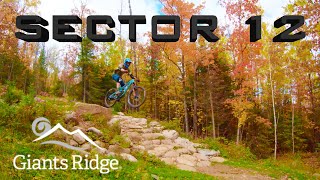
Sector 12 is gravity riding at its finest and is sure to excite even the most experienced gravity mountain bikers. Sector 12 contains all the elements of a true bike park style trail, including: massive berms, big jumps, fun flowy rollers, rock drops, bouldery rock gardens, all experienced at lightning speed. Although Sector 12 is designed to put you in the air, your tires don’t need to leave the ground unless you choose. Optional extremely difficult B-lines exist, which include rock drops and even a gap jump. Sector 12 showcases the GIANT granite boulders that are plentiful on the mountain.

source: ...
Access Info

Accessible from the top of the Sarajevo Express Chairlift. Check the Giants Ridge website for current operating hours.

Disclaimer

CLOSED whenever the chairlift is not operating.

Trail Supporters

Bike Park

Recent Activity on Trail

Past Week
  • 2 rides
  • 36.7 km average
6 Months
  • 7 rides
  • 27.9 km avg distance
All
  • 170 rides
  • Last: Jun 19, 2026
c1c2c3c4
January
February
March
April
May
June
July
August
September
October
November
December
update trails status or condition

DH - Sector 12 Trail Reports

Status:
on Jun 19, 2026
Ideal
Avg: 4.08 (5 votes)
Your vote: 0

view (1,893)
close
3D
Trail Conditions
  • Unknown
  • Snow Groomed
  • Snow Packed
  • Snow Covered
  • Snow Cover Partial
  • Freeze/thaw Cycle
  • Icy
  • Prevalent Mud
  • Wet
  • Variable
  • Ideal
  • Dry
  • Very Dry
Trail Flow (Ridden Direction)
Trailforks scans users ridelogs to determine the most popular direction each trail is ridden. A good flowing trail network will have most trails flowing in a single direction according to their intension.
The colour categories are based on what percentage of riders are riding a trail in its intended direction.
  • > 96%
  • > 90%
  • > 80%
  • > 70%
  • > 50%
  • < 50%
  • bi-directional trail
  • no data
Trail Last Ridden
Trailforks scans ridelogs to determine the last time a trail was ridden.
  • < 2 days
  • < 1 week
  • < 2 weeks
  • < 1 month
  • < 6 months
  • > 6 months
Trail Ridden Direction
The intended direction a trail should be ridden.
  • Downhill Only
  • Downhill Primary
  • Both Directions
  • Uphill Primary
  • Uphill Only
  • One Direction
Contribute Details
Colors indicate trail is missing specified detail.
  • Description
  • Photos
  • Description & Photos
  • Videos
Trail Popularity ?
Trailforks scans ridelogs to determine which trails are ridden the most in the last 9 months. Trails are compared with nearby trails in the same city region with a possible 25 colour shades. Think of this as a heatmap, more rides = more kinetic energy = warmer colors.
  • most popular
  • popular
  • less popular
  • not popular
ATV/ORV/OHV Filter
Max Vehicle Width
inches
US Cell Coverage
Legend
cell carrier legend

Radar Time
Activity Recordings
Trailforks uses anonymized public activity data. ?
Activity Recordings
Trailforks uses anonymized public activity data. ?
Personal Heatmap
Activity Types
all / none
Options
2
Date range month
Winter Trails
Warning A routing network for winter maps does not exist. Selecting trails using the winter trails layer has been disabled.
Missing Trails
Most Popular
Least Popular
Trails are colored based on popularity. The more popular a trail is, the more red. Less popular trails trend towards green.
Jump Magnitude Heatmap
Heatmap of where riders jump on trails. Zoom in to see individual jumps, click circles to view jump details.
BC Backroad Status

Service Road Atlas is a free to use, community-driven service for viewing and creating reports on the numerous back-country service roads around B.C. and Alberta.

map legend
Slope Aspect
Direction the slope faces
Flat N NE E SE S SW W NW
Trails Deemphasized
Trails are shown in grey.
disable
Only show trails with no bike usage.
Enable
Suggested Layers
Based on selected activity type

    Save the current map location and zoom level as your default home location whenever this page is loaded.

    Save
        Directions to dh-sector-12 trailhead (47.571780, -92.309850)

        Photos

        10 more »
        187 |
        Jul 17, 2022 @ 9:05am
        Jul 17, 2022
        186 |
        Jul 17, 2022 @ 9:04am
        Jul 17, 2022
        169 |
        Jul 17, 2022 @ 9:04am
        Jul 17, 2022
        202 |
        Jul 17, 2022 @ 9:04am
        Jul 17, 2022

        Videos

        5 more »
        Giant's Ridge Bike Park! Classic Downhill...
        12:25 | 159 | Mar 23, 2024 , Biwabik
        Giants Ridge mountain biking down Sector 12,...
        5:13 | 451 | Apr 27, 2021 , Biwabik
        Giants Ridge Sector 12
        3:08 | 413 | Oct 5, 2020 , Biwabik
        youtuber First Ride on Leapfrog and Sector 12 at...
        8:19 | 1682 | Jul 10, 2020 , Biwabik

        1 Review & Comments


        We hope you've been enjoying Trailforks!

        Create a FREE account to view trail comments and much more.

        • By DeadThrone & contributors
        • #141546 - 2,398 views

        Frequently Asked Questions About DH - Sector 12

        Where is DH - Sector 12 located?
        DH - Sector 12 is located in Giants Ridge, Biwabik, Minnesota, United States. It is part of the Giants Ridge trail network. The trailhead is located at coordinates 47.57178, -92.30985.
        How hard is DH - Sector 12?
        DH - Sector 12 is rated as Black Diamond difficulty. The average grade is 11.4%.
        What is the elevation gain for DH - Sector 12?
        The trail has 371 ft of elevation descent. The elevation ranges from 1,448 ft to 1,818 ft.
        How long is DH - Sector 12?
        DH - Sector 12 is 3,241 ft long. The trail type is singletrack.

        Hit the Trail

        Open in App

        Get this trail on your phone instantly.
        open trail in app

        Download Trail

        Save to wishlist, Garmin & download.
        save the trail

        Find Related Routes

        Find routes and users activities that include this trail.
        find routes for this trail

        You must enter a description before submitting.