more stats
1.7 miles
Distance
47 ft
Climb
-849 ft
Descent
00:17:50
Avg time
-802 ft
Altitude change
20 ft
Altitude min
821 ft
Altitude max
821 ft
Altitude start
20 ft
Altitude end
-8.8%
Grade
-56%
Grade max
17.8%
Grade min
1,355 ft
Distance climb
1 mile
Distance down
620 ft
Distance flat
00:17:50
Avg time

Semaforo Details

  • Activities
    • Mountain Bike
    • E-Bike
    • Hike
    • Trail Running
  • Riding Area
    Finale Outdoor Region
    Finale Ligure
  • Ref Number
    #8
  • AKA
    DH Semaforo Capo Noli
  • Difficulty Rating
  • Voted Difficulty
    Blue (2 votes)
  • Local Popularity
    45 in Mountain Biking [+]
    • 50 in E-Biking
    • 95 in Trail Running
    • 100 in Hiking
  • Global Ranking
    #101804 in Mountain Biking [+]
    • #55402 in E-Biking
    • #606 in Trail Running
    • #1418 in Hiking
  • Hiking SAC Scale
    T1 Hiking
  • Trail Type
    Singletrack
  • Bike Type
    AM, XC
  • Climb Difficulty
    Green
  • Physical Rating
    Moderate
  • Trail Visibility
    Sometimes hard to follow
  • Season
    All-year round
  • Dogs Allowed
    Yes
  • eBike Allowed
    Yes up to Class 1
  • TTFs on Trail
    Rock Garden
  • Land Owner

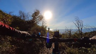
A beautiful line that connects the Le Manie plateau to Noli.
With a few minutes of walking, it gives access to some stunning view points out of the beaten tracks, such as Grotta dei Falsari and Santa Margherita church above Capo Noli.

It can be used as a mellow, fun downhill or a challenging short climb to Le Manie.

source: ...
Access Info

Le Manie Area is reachable from the E80 highway accessing Spotorno. You'll need to take the SP8, then the SP45 towards Voze and you'll soon get to the top of the plateau.
Other option is getting out of the E80 in Finale Ligure, cross the town on the Aurelia (SS1) and driving up toward Le Manie on the SP45

Disclaimer

Trail often used by hikers. Be careful and respectful. Given its nature, the trail can change after weather happenings and season changes. Always pay attention

Local Trail Association

Recent Activity on Trail

Past Week
  • 0 rides
  •  
6 Months
  • 24 rides
  • 35.2 km avg distance
All
  • 129 rides
  • Last: Jun 13, 2026
c1c2c3c4
January
February
March
April
May
June
July
August
September
October
November
December
Status:
on Apr 28, 2026
Ideal
Avg: 3.58 (7 votes)
Your vote: 0

view (1,173)
close
3D
Trail Conditions
  • Unknown
  • Snow Groomed
  • Snow Packed
  • Snow Covered
  • Snow Cover Partial
  • Freeze/thaw Cycle
  • Icy
  • Prevalent Mud
  • Wet
  • Variable
  • Ideal
  • Dry
  • Very Dry
Trail Flow (Ridden Direction)
Trailforks scans users ridelogs to determine the most popular direction each trail is ridden. A good flowing trail network will have most trails flowing in a single direction according to their intension.
The colour categories are based on what percentage of riders are riding a trail in its intended direction.
  • > 96%
  • > 90%
  • > 80%
  • > 70%
  • > 50%
  • < 50%
  • bi-directional trail
  • no data
Trail Last Ridden
Trailforks scans ridelogs to determine the last time a trail was ridden.
  • < 2 days
  • < 1 week
  • < 2 weeks
  • < 1 month
  • < 6 months
  • > 6 months
Trail Ridden Direction
The intended direction a trail should be ridden.
  • Downhill Only
  • Downhill Primary
  • Both Directions
  • Uphill Primary
  • Uphill Only
  • One Direction
Contribute Details
Colors indicate trail is missing specified detail.
  • Description
  • Photos
  • Description & Photos
  • Videos
Trail Popularity ?
Trailforks scans ridelogs to determine which trails are ridden the most in the last 9 months. Trails are compared with nearby trails in the same city region with a possible 25 colour shades. Think of this as a heatmap, more rides = more kinetic energy = warmer colors.
  • most popular
  • popular
  • less popular
  • not popular
ATV/ORV/OHV Filter
Max Vehicle Width
inches
US Cell Coverage
Legend
cell carrier legend

Radar Time
Activity Recordings
Trailforks uses anonymized public activity data. ?
Activity Recordings
Trailforks uses anonymized public activity data. ?
Personal Heatmap
Activity Types
all / none
Options
2
Date range month
Winter Trails
Warning A routing network for winter maps does not exist. Selecting trails using the winter trails layer has been disabled.
Missing Trails
Most Popular
Least Popular
Trails are colored based on popularity. The more popular a trail is, the more red. Less popular trails trend towards green.
Jump Magnitude Heatmap
Heatmap of where riders jump on trails. Zoom in to see individual jumps, click circles to view jump details.
BC Backroad Status

Service Road Atlas is a free to use, community-driven service for viewing and creating reports on the numerous back-country service roads around B.C. and Alberta.

map legend
Slope Aspect
Direction the slope faces
Flat N NE E SE S SW W NW
Trails Deemphasized
Trails are shown in grey.
disable
Only show trails with no bike usage.
Enable
Suggested Layers
Based on selected activity type

    Save the current map location and zoom level as your default home location whenever this page is loaded.

    Save
        Directions to semaforo trailhead (44.193950, 8.418070)

        Photos

        11 more »
        42 |
        May 24, 2025 @ 1:20am
        May 24, 2025
        53 |
        Mar 8, 2025 @ 12:54am
        Mar 8, 2025
        120 |
        Mar 28, 2023 @ 2:51pm
        Mar 28, 2023
        146 |
        May 11, 2022 @ 2:52am
        May 11, 2022

        Videos

        5 more »
        Finale Ligure eMTBing - Trail Semaforo
        13:28 | 138 | Dec 14, 2025 , Finale Ligure
        Finale Ligure eMTBing - Trail Semaforo
        8:25 | 177 | Dec 24, 2024 , Finale Ligure
        Finale Ligure eMTBing - Trail Semaforo (Le Manie)
        8:54 | 576 | Dec 29, 2022 , Finale Ligure
        Le Manie mountain biking
        11:11 | 426 | Jan 4, 2022 , Finale Ligure

        Routes with this trail

        17 miles 2,502 ft 2
        We found this route and stayed married! Recommended on an ebike. There was a couple of rocky decents of no...
        18 miles 3,076 ft 7
        Gemütliche Rundtour mit zwei Aufstiegen und schönen flowigen Trails. Bis auf den Trail "Cave" gibt es...
        3.0 12 miles 2,758 ft 9
        Tracciato 24 ore più variante capo Noli

        7 Reviews & Comments


        We hope you've been enjoying Trailforks!

        Create a FREE account to view trail comments and much more.

        • By finaleoutdoorregion FOR & contributors
        • #223490 - 3,172 views

        Frequently Asked Questions About Semaforo

        Where is Semaforo located?
        Semaforo is located in Finale Outdoor Region, Finale Ligure, Italy. It is part of the Finale Outdoor Region trail network. The trailhead is located at coordinates 44.19395, 8.41807.
        How hard is Semaforo?
        Semaforo is rated as Blue difficulty. The physical rating is Moderate. The average grade is 8.8%. The climb difficulty is rated Green.
        What is the elevation gain for Semaforo?
        Semaforo has 47 ft of elevation gain. The trail has 849 ft of elevation descent. The elevation ranges from 20 ft to 821 ft.
        How long is Semaforo?
        Semaforo is 1.7 miles long. The trail type is singletrack.

        Hit the Trail

        Open in App

        Get this trail on your phone instantly.
        open trail in app

        Download Trail

        Save to wishlist, Garmin & download.
        save the trail

        Find Related Routes

        Find routes and users activities that include this trail.
        find routes for this trail

        You must enter a description before submitting.