more stats
2,644 ft
Distance
7 ft
Climb
-305 ft
Descent
00:06:50
Avg time
-299 ft
Altitude change
681 ft
Altitude min
980 ft
Altitude max
980 ft
Altitude start
682 ft
Altitude end
-11.3%
Grade
-23.7%
Grade max
10.9%
Grade min
92 ft
Distance climb
2,287 ft
Distance down
269 ft
Distance flat
00:06:50
Avg time

Sempiternal Details

  • Activities
    • Mountain Bike
    • E-Bike
  • Riding Area
    Westwood
    Nanaimo, British Columbia
  • Difficulty Rating
  • Voted Difficulty
    Blue (4 votes)
  • Local Popularity
    100 in Mountain Biking [+]
    • 95 in E-Biking
  • Global Ranking
    #11697 in Mountain Biking [+]
    • #2143 in E-Biking
  • Trail Type
    Singletrack
  • Bike Type
    DH, AM, XC
  • Direction
    Downhill Only
    Popular Direction Shown
  • Physical Rating
    Moderate
  • Trail Visibility
    Always easy to follow
  • Dogs Allowed
    Yes
  • eBike Allowed
    Yes up to Class 1
  • TTFs on Trail
    Berm, Jump, Gap Jump

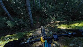
Very high-speed downhill mountain bike trail, one of the most popular flow trails in Nanaimo. Super fun berms, jumps and two drops with roll downs. Great trail for leaning skills and progression.
For everyone's safety, please do not hike on this trail and keep dogs on-leash unless riding down it.
Sempiternal \sem-pih-TER-nul\ adjective. : of never-ending duration : eternal.

Trail Supporters
Local Trail Association
Traditionally Indigenous Territory

Recent Activity on Trail

Past Week
  • 17 rides
  • 7 miles average
6 Months
  • 340 rides
  • 7 miles avg distance
All
  • 2,676 rides
  • Last: Jun 16, 2026
c1c2c3c4
January
February
March
April
May
June
July
August
September
October
November
December
Status:
on Apr 25, 2026
Ideal
Avg: 4.53 (26 votes)
Your vote: 0

view (12,650)
close
3D
Trail Conditions
  • Unknown
  • Snow Groomed
  • Snow Packed
  • Snow Covered
  • Snow Cover Partial
  • Freeze/thaw Cycle
  • Icy
  • Prevalent Mud
  • Wet
  • Variable
  • Ideal
  • Dry
  • Very Dry
Trail Flow (Ridden Direction)
Trailforks scans users ridelogs to determine the most popular direction each trail is ridden. A good flowing trail network will have most trails flowing in a single direction according to their intension.
The colour categories are based on what percentage of riders are riding a trail in its intended direction.
  • > 96%
  • > 90%
  • > 80%
  • > 70%
  • > 50%
  • < 50%
  • bi-directional trail
  • no data
Trail Last Ridden
Trailforks scans ridelogs to determine the last time a trail was ridden.
  • < 2 days
  • < 1 week
  • < 2 weeks
  • < 1 month
  • < 6 months
  • > 6 months
Trail Ridden Direction
The intended direction a trail should be ridden.
  • Downhill Only
  • Downhill Primary
  • Both Directions
  • Uphill Primary
  • Uphill Only
  • One Direction
Contribute Details
Colors indicate trail is missing specified detail.
  • Description
  • Photos
  • Description & Photos
  • Videos
Trail Popularity ?
Trailforks scans ridelogs to determine which trails are ridden the most in the last 9 months. Trails are compared with nearby trails in the same city region with a possible 25 colour shades. Think of this as a heatmap, more rides = more kinetic energy = warmer colors.
  • most popular
  • popular
  • less popular
  • not popular
ATV/ORV/OHV Filter
Max Vehicle Width
inches
US Cell Coverage
Legend
cell carrier legend

Radar Time
Activity Recordings
Trailforks uses anonymized public activity data. ?
Activity Recordings
Trailforks uses anonymized public activity data. ?
Personal Heatmap
Activity Types
all / none
Options
2
Date range month
Winter Trails
Warning A routing network for winter maps does not exist. Selecting trails using the winter trails layer has been disabled.
Missing Trails
Most Popular
Least Popular
Trails are colored based on popularity. The more popular a trail is, the more red. Less popular trails trend towards green.
Jump Magnitude Heatmap
Heatmap of where riders jump on trails. Zoom in to see individual jumps, click circles to view jump details.
BC Backroad Status

Service Road Atlas is a free to use, community-driven service for viewing and creating reports on the numerous back-country service roads around B.C. and Alberta.

map legend
Slope Aspect
Direction the slope faces
Flat N NE E SE S SW W NW
Trails Deemphasized
Trails are shown in grey.
disable
Only show trails with no bike usage.
Enable
Suggested Layers
Based on selected activity type

    Save the current map location and zoom level as your default home location whenever this page is loaded.

    Save
        Directions to sempiternal trailhead (49.157900, -124.013930)

        Photos

        21 more »
        281 |
        Mar 29, 2021 @ 7:58pm
        Mar 29, 2021
        36 |
        May 6, 2026 @ 3:24pm
        May 6, 2026
        36 |
        May 6, 2026 @ 3:24pm
        May 6, 2026
        39 |
        May 6, 2026 @ 5:34am
        May 6, 2026

        Videos

        9 more »
        Westwood Lake | Nanaimo, BC
        7:08 | 298 | Feb 13, 2025 , Nanaimo
        Hand Built Flow | Shenanigans, Nanaimo B.C....
        2:57 | 887 | Apr 26, 2022 , Nanaimo
        youtuber MTB Action 4K | Shenanigans #Shorts #mtb...
        0:00 | 276 | Mar 9, 2022 , Nanaimo
        youtuber MTB Riding Shenanigans | New Trail Day!!! | at...
        7:15 | 393 | Nov 1, 2021 , Nanaimo

        Routes with this trail

        4.5 5 miles 969 ft 8 Loop
        Nice little quick loop around Westwood Lake - easy climbs for beginners or hardtails.
        5.0 22 miles 3,391 ft 16
        Four distinct zones, very pedalable with a few very hard climbs. Some ripper downs. Well built, modern...
        3 miles 582 ft 7
        Legalize It Arbot rd entrance to Lower to 5 Brothers on to for a bit then up to the freshly groomed...

        5 Reviews & Comments


        We hope you've been enjoying Trailforks!

        Create a FREE account to view trail comments and much more.

        • By DSPhotoTF Pro & contributors
        • #48501 - 7,932 views

        Frequently Asked Questions About Sempiternal

        Where is Sempiternal located?
        Sempiternal is located in Westwood, Nanaimo, British Columbia, Canada. It is part of the Westwood trail network. The trailhead is located at coordinates 49.1579, -124.01393.
        How hard is Sempiternal?
        Sempiternal is rated as Black Diamond difficulty. The physical rating is Moderate. The average grade is 11.3%.
        What is the elevation gain for Sempiternal?
        Sempiternal has 7 ft of elevation gain. The trail has 305 ft of elevation descent. The elevation ranges from 681 ft to 980 ft.
        Is Sempiternal a point to point trail?
        Yes, Sempiternal is a point to point trail. The direction is Downhill Only. The trail type is singletrack.

        Hit the Trail

        Open in App

        Get this trail on your phone instantly.
        open trail in app

        Download Trail

        Save to wishlist, Garmin & download.
        save the trail

        Find Related Routes

        Find routes and users activities that include this trail.
        find routes for this trail

        You must enter a description before submitting.