more stats
2,136 ft
Distance
156 ft
Climb
00:07:03
Avg time
156 ft
Altitude change
518 ft
Altitude min
674 ft
Altitude max
518 ft
Altitude start
673 ft
Altitude end
7.3%
Grade
-1.4%
Grade max
29.6%
Grade min
1,644 ft
Distance climb
141 ft
Distance down
351 ft
Distance flat
00:07:03
Avg time

Seven (7) Details

  • Activities
    • Mountain Bike
    • E-Bike
    • Winter Fat Bike
    • Hike
    • Trail Running
  • Riding Area
    Hartland Mountain Bike Park
    Victoria, British Columbia
  • Difficulty Rating
  • Local Popularity
    85 in Mountain Biking [+]
    • 90 in E-Biking
    • 45 in Trail Running
    • 80 in Hiking
  • Global Ranking
    #48870 in Mountain Biking [+]
    • #24681 in E-Biking
    • #112248 in Trail Running
    • #65872 in Hiking
  • Hiking SAC Scale
    T2 Mountain Hiking
  • Trail Type
    Singletrack
  • Bike Type
    AM, XC, Fat, CX
  • Direction
    Both Directions
  • Climb Difficulty
    Blue
  • Physical Rating
    Moderate
  • Trail Visibility
    Always easy to follow
  • Dogs Allowed
    Yes
  • eBike Allowed
    Yes up to Class 1
  • TTFs on Trail
    Berm, Jump
  • Ride in Rain
    Yes
  • Land Owner

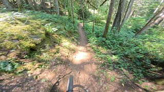
Excellent trail with some bermed turns and tight switchback turns. Skill at doing endo turns would help. Just enough trail width with some moderate exposure in some spots.

Shallow stream crossing in the middle. Two small booters near the end with good takeoffs and landings.

Thoroughly enjoyable.

This trail is unsanctioned.

Recent Activity on Trail

Past Week
  • 9 rides
  • 13 miles average
6 Months
  • 185 rides
  • 9 miles avg distance
All
  • 1,702 rides
  • Last: Jun 21, 2026
c1c2c3c4
January
February
March
April
May
June
July
August
September
October
November
December
Status:
on Jun 21, 2026
Dry
Avg: 3.87 (10 votes)
Your vote: 0

view (9,595)
close
3D
Trail Conditions
  • Unknown
  • Snow Groomed
  • Snow Packed
  • Snow Covered
  • Snow Cover Partial
  • Freeze/thaw Cycle
  • Icy
  • Prevalent Mud
  • Wet
  • Variable
  • Ideal
  • Dry
  • Very Dry
Trail Flow (Ridden Direction)
Trailforks scans users ridelogs to determine the most popular direction each trail is ridden. A good flowing trail network will have most trails flowing in a single direction according to their intension.
The colour categories are based on what percentage of riders are riding a trail in its intended direction.
  • > 96%
  • > 90%
  • > 80%
  • > 70%
  • > 50%
  • < 50%
  • bi-directional trail
  • no data
Trail Last Ridden
Trailforks scans ridelogs to determine the last time a trail was ridden.
  • < 2 days
  • < 1 week
  • < 2 weeks
  • < 1 month
  • < 6 months
  • > 6 months
Trail Ridden Direction
The intended direction a trail should be ridden.
  • Downhill Only
  • Downhill Primary
  • Both Directions
  • Uphill Primary
  • Uphill Only
  • One Direction
Contribute Details
Colors indicate trail is missing specified detail.
  • Description
  • Photos
  • Description & Photos
  • Videos
Trail Popularity ?
Trailforks scans ridelogs to determine which trails are ridden the most in the last 9 months. Trails are compared with nearby trails in the same city region with a possible 25 colour shades. Think of this as a heatmap, more rides = more kinetic energy = warmer colors.
  • most popular
  • popular
  • less popular
  • not popular
ATV/ORV/OHV Filter
Max Vehicle Width
inches
US Cell Coverage
Legend
cell carrier legend

Radar Time
Activity Recordings
Trailforks uses anonymized public activity data. ?
Activity Recordings
Trailforks uses anonymized public activity data. ?
Personal Heatmap
Activity Types
all / none
Options
2
Date range month
Winter Trails
Warning A routing network for winter maps does not exist. Selecting trails using the winter trails layer has been disabled.
Missing Trails
Most Popular
Least Popular
Trails are colored based on popularity. The more popular a trail is, the more red. Less popular trails trend towards green.
Jump Magnitude Heatmap
Heatmap of where riders jump on trails. Zoom in to see individual jumps, click circles to view jump details.
BC Backroad Status

Service Road Atlas is a free to use, community-driven service for viewing and creating reports on the numerous back-country service roads around B.C. and Alberta.

map legend
Slope Aspect
Direction the slope faces
Flat N NE E SE S SW W NW
Trails Deemphasized
Trails are shown in grey.
disable
Only show trails with no bike usage.
Enable
Suggested Layers
Based on selected activity type

    Save the current map location and zoom level as your default home location whenever this page is loaded.

    Save
        Directions to seven-7 trailhead (48.545220, -123.477340)

        Photos

        9 more »
        9 |
        Jun 17, 2026 @ 8:37pm
        Jun 17, 2026
        86 |
        Jan 20, 2023 @ 7:59pm
        Jan 20, 2023
        117 |
        Aug 30, 2021 @ 2:46pm
        Aug 30, 2021
        178 |
        Jan 25, 2020 @ 3:42pm
        Jan 25, 2020

        Videos

        3 more »
        Trillium on to Seven - Hartland 2026
        11 | May 21, 2026 , Victoria
        Trillium to Seven (Down) - July 1st, 2024
        6:35 | 89 | Jul 18, 2024 , Victoria
        7 (Climb) at Hartland Bike Park, Saanich, BC
        6:36 | 149 | Nov 3, 2023 , Victoria

        Routes with this trail

        1.0 6 miles 1,110 ft 17
        This loop suggestion is part of our Community Routes—a group of routes created by the community, for the...
        2 miles 485 ft 6 Loop
        This loop suggestion is part of our —a group of routes created by the community, for the community. The...
        10 miles 2,668 ft 14
        Hartland Downcountry Idea

        2 Reviews & Comments


        We hope you've been enjoying Trailforks!

        Create a FREE account to view trail comments and much more.

        • #246313 - 2,163 views

        Frequently Asked Questions About Seven (7)

        Where is Seven (7) located?
        Seven (7) is located in Hartland Mountain Bike Park, Victoria, British Columbia, Canada. It is part of the Hartland Mountain Bike Park trail network. The trailhead is located at coordinates 48.54522, -123.47734.
        How hard is Seven (7)?
        Seven (7) is rated as Blue difficulty. The physical rating is Moderate. The average grade is 7.3%. The climb difficulty is rated Blue.
        What is the elevation gain for Seven (7)?
        Seven (7) has 48 m of elevation gain. The elevation ranges from 158 m to 205 m.
        Is Seven (7) a point to point trail?
        Seven (7) is not a point to point trail. The direction is Both Directions. The trail type is singletrack.

        Hit the Trail

        Open in App

        Get this trail on your phone instantly.
        open trail in app

        Download Trail

        Save to wishlist, Garmin & download.
        save the trail

        Find Related Routes

        Find routes and users activities that include this trail.
        find routes for this trail

        You must enter a description before submitting.