more stats
1.4 miles
Distance
48 ft
Climb
-806 ft
Descent
00:10:38
Avg time
-760 ft
Altitude change
1,274 ft
Altitude min
2,034 ft
Altitude max
2,034 ft
Altitude start
1,273 ft
Altitude end
-10.4%
Grade
-63.8%
Grade max
23.3%
Grade min
669 ft
Distance climb
1 mile
Distance down
1,191 ft
Distance flat
00:10:38
Avg time

Shale Trail Details

  • Activities
    • Mountain Bike
    • Winter Fat Bike
  • Riding Area
    Knox Mountain Park
    Kelowna, British Columbia
  • Difficulty Rating
  • Voted Difficulty
    Black Diamond (3 votes)
  • Local Popularity
    100 in Mountain Biking
  • Global Ranking
    #28916 in Mountain Biking
  • Trail Type
    Singletrack
  • Bike Type
    DH, AM, XC, Fat
  • Direction
    Downhill Only
    Popular Direction Shown
  • Physical Rating
    Moderate
  • Trail Visibility
    Always easy to follow
  • Season
    Feb-Dec
  • Dogs Allowed
    Yes
  • TTFs on Trail
    Berm, Drop, Jump, Rock Face
  • Land Owner
    city of kelowna

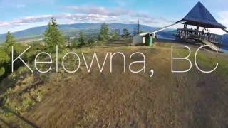
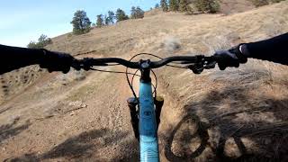
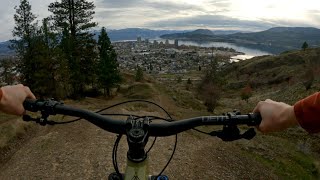
Mountain bike descent from the top of Knox Mountain. Some older rock roll lines exist but a groomed berm and jump line has been built for the full descent. This is a very short and fast descent with a paved road to the top. There is a parking lot near the top if you want to shuttle but pedalling up only takes about 20 minutes. Great views of the city and lake

Access Info

Accessed from the lookout at the summit of Knox Mountain Park.

Trail Supporters
Local Trail Association

Recent Activity on Trail

Past Week
  • 5 rides
  • 9 miles average
6 Months
  • 159 rides
  • 9 miles avg distance
All
  • 1,491 rides
  • Last: Jun 24, 2026
c1c2c3c4
January
February
March
April
May
June
July
August
September
October
November
December
update trails status or condition

Shale Trail Trail Reports

Status:
on Mar 17, 2026
Ideal
Avg: 4.13 (24 votes)
Your vote: 0

view (10,850)
close
3D
Trail Conditions
  • Unknown
  • Snow Groomed
  • Snow Packed
  • Snow Covered
  • Snow Cover Partial
  • Freeze/thaw Cycle
  • Icy
  • Prevalent Mud
  • Wet
  • Variable
  • Ideal
  • Dry
  • Very Dry
Trail Flow (Ridden Direction)
Trailforks scans users ridelogs to determine the most popular direction each trail is ridden. A good flowing trail network will have most trails flowing in a single direction according to their intension.
The colour categories are based on what percentage of riders are riding a trail in its intended direction.
  • > 96%
  • > 90%
  • > 80%
  • > 70%
  • > 50%
  • < 50%
  • bi-directional trail
  • no data
Trail Last Ridden
Trailforks scans ridelogs to determine the last time a trail was ridden.
  • < 2 days
  • < 1 week
  • < 2 weeks
  • < 1 month
  • < 6 months
  • > 6 months
Trail Ridden Direction
The intended direction a trail should be ridden.
  • Downhill Only
  • Downhill Primary
  • Both Directions
  • Uphill Primary
  • Uphill Only
  • One Direction
Contribute Details
Colors indicate trail is missing specified detail.
  • Description
  • Photos
  • Description & Photos
  • Videos
Trail Popularity ?
Trailforks scans ridelogs to determine which trails are ridden the most in the last 9 months. Trails are compared with nearby trails in the same city region with a possible 25 colour shades. Think of this as a heatmap, more rides = more kinetic energy = warmer colors.
  • most popular
  • popular
  • less popular
  • not popular
ATV/ORV/OHV Filter
Max Vehicle Width
inches
US Cell Coverage
Legend
cell carrier legend

Radar Time
Activity Recordings
Trailforks uses anonymized public activity data. ?
Activity Recordings
Trailforks uses anonymized public activity data. ?
Personal Heatmap
Activity Types
all / none
Options
2
Date range month
Winter Trails
Warning A routing network for winter maps does not exist. Selecting trails using the winter trails layer has been disabled.
Missing Trails
Most Popular
Least Popular
Trails are colored based on popularity. The more popular a trail is, the more red. Less popular trails trend towards green.
Jump Magnitude Heatmap
Heatmap of where riders jump on trails. Zoom in to see individual jumps, click circles to view jump details.
BC Backroad Status

Service Road Atlas is a free to use, community-driven service for viewing and creating reports on the numerous back-country service roads around B.C. and Alberta.

map legend
Slope Aspect
Direction the slope faces
Flat N NE E SE S SW W NW
Trails Deemphasized
Trails are shown in grey.
disable
Only show trails with no bike usage.
Enable
Suggested Layers
Based on selected activity type

    Save the current map location and zoom level as your default home location whenever this page is loaded.

    Save
        Directions to shale-trail trailhead (49.911520, -119.484990)

        Photos

        93 more »
        1,240 |
        Mar 5, 2016 @ 11:08pm
        Mar 5, 2016
        73 |
        Apr 21, 2025 @ 6:51pm
        Apr 21, 2025
        123 |
        May 19, 2022 @ 4:30pm
        May 19, 2022
        103 |
        Apr 28, 2022 @ 10:35pm
        Apr 28, 2022

        Videos

        23 more »
        youtuber Whistler Mountain Biking - Duncan's to AM/PM
        1128 | May 9, 2016 , Kelowna
        youtuber Kelowna, BC Mountain Biking - Shale Trail
        3:35 | 478 | Jun 14, 2016 , Kelowna
        Knox Mountain Shale Trail
        3:31 | 617 | Feb 15, 2023 , Kelowna
        Knox Mtn | Raw MTB | Kelowna BC
        4:53 | 590 | Apr 12, 2022 , Kelowna

        Routes with this trail

        4.0 5 miles 1,164 ft 5 Loop
        For this Sovereign Cycle group ride we're heading up the (instead of the road) to the upper lookout. From...
        5 miles 1,104 ft 8 Loop
        A fun loop of Knox with a small traverse on the way down cutting off of to ride all of .
        1.0 5 miles 1,156 ft 6
        Okanagan NE Knox Classic Okanagan North East Relive Your Rides For other ride suggestions for this and...

        Reviews / Comments

        No reviews yet, be the first to write a review or ask a question.
        Use trail reports to comment on trail conditions.


        We hope you've been enjoying Trailforks!

        Create a FREE account to view trail comments and much more.

        • By keeqanTF Pro & contributors
        • #18408 - 13,362 views

        Frequently Asked Questions About Shale Trail

        Where is Shale Trail located?
        Shale Trail is located in Knox Mountain Park, Kelowna, British Columbia, Canada. It is part of the Knox Mountain Park trail network. The trailhead is located at coordinates 49.91152, -119.48499.
        How hard is Shale Trail?
        Shale Trail is rated as Blue difficulty. The physical rating is Moderate. The average grade is 10.4%.
        What is the elevation gain for Shale Trail?
        Shale Trail has 48 ft of elevation gain. The trail has 806 ft of elevation descent. The elevation ranges from 1,274 ft to 2,034 ft.
        Is Shale Trail a point to point trail?
        Yes, Shale Trail is a point to point trail. The direction is Downhill Only. The trail type is singletrack.

        Hit the Trail

        Open in App

        Get this trail on your phone instantly.
        open trail in app

        Download Trail

        Save to wishlist, Garmin & download.
        save the trail

        Find Related Routes

        Find routes and users activities that include this trail.
        find routes for this trail

        You must enter a description before submitting.