more stats
2,507 ft
Distance
-238 ft
Descent
00:04:00
Avg time
-238 ft
Altitude change
718 ft
Altitude min
955 ft
Altitude max
955 ft
Altitude start
719 ft
Altitude end
-9.5%
Grade
-28.3%
Grade max
-1.8%
Grade min
2,507 ft
Distance down
00:04:00
Avg time

Shotgun Details

  • Activities
    • Mountain Bike
    • Hike
    • Trail Running
  • Riding Area
    Woodlot
    Maple Ridge, British Columbia
  • AKA
    Upper Shotgun, Lower Shotgun
  • Difficulty Rating
  • Voted Difficulty
    Blue (1 vote)
  • Local Popularity
    90 in Mountain Biking [+]
    • 50 in Trail Running
    • 70 in Hiking
  • Global Ranking
    #29396 in Mountain Biking [+]
    • #116178 in Trail Running
    • #89227 in Hiking
  • Trail Type
    Singletrack
  • Bike Type
    DH, AM, XC
  • Climb Difficulty
    Black Diamond
  • Physical Rating
    Hard
  • Dogs Allowed
    Yes
  • eBike Allowed
  • TTFs on Trail
    Bridge, Drop, Jump, Ladder Bridge
  • Ride in Rain
    Yes

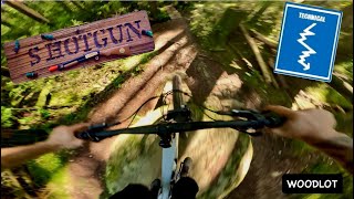
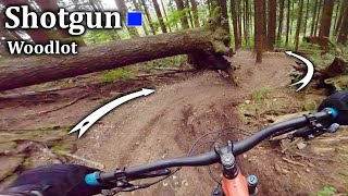
Shotgun is the mountain bikers home trail for the Maple Ridge Woodlot area, pretty much dropping you at your car door. It's mellow, smooth, flowy and natural, a good first ride if you haven't ridden the area before.

Access Info

Accessed off Woodlot Main FSR across from the bottom of Bloggy Style.

Trail Supporters

  • Ryando

    since 2007
    Builder
  • past supporters

Local Trail Association

Recent Activity on Trail

Past Week
  • 9 rides
  • 7 miles average
6 Months
  • 204 rides
  • 7 miles avg distance
All
  • 2,443 rides
  • Last: Jun 17, 2026
c1c2c3c4
January
February
March
April
May
June
July
August
September
October
November
December
Status:
on May 17, 2026
Ideal
Avg: 3.91 (40 votes)
Your vote: 0

view (10,113)
close
3D
Trail Conditions
  • Unknown
  • Snow Groomed
  • Snow Packed
  • Snow Covered
  • Snow Cover Partial
  • Freeze/thaw Cycle
  • Icy
  • Prevalent Mud
  • Wet
  • Variable
  • Ideal
  • Dry
  • Very Dry
Trail Flow (Ridden Direction)
Trailforks scans users ridelogs to determine the most popular direction each trail is ridden. A good flowing trail network will have most trails flowing in a single direction according to their intension.
The colour categories are based on what percentage of riders are riding a trail in its intended direction.
  • > 96%
  • > 90%
  • > 80%
  • > 70%
  • > 50%
  • < 50%
  • bi-directional trail
  • no data
Trail Last Ridden
Trailforks scans ridelogs to determine the last time a trail was ridden.
  • < 2 days
  • < 1 week
  • < 2 weeks
  • < 1 month
  • < 6 months
  • > 6 months
Trail Ridden Direction
The intended direction a trail should be ridden.
  • Downhill Only
  • Downhill Primary
  • Both Directions
  • Uphill Primary
  • Uphill Only
  • One Direction
Contribute Details
Colors indicate trail is missing specified detail.
  • Description
  • Photos
  • Description & Photos
  • Videos
Trail Popularity ?
Trailforks scans ridelogs to determine which trails are ridden the most in the last 9 months. Trails are compared with nearby trails in the same city region with a possible 25 colour shades. Think of this as a heatmap, more rides = more kinetic energy = warmer colors.
  • most popular
  • popular
  • less popular
  • not popular
ATV/ORV/OHV Filter
Max Vehicle Width
inches
US Cell Coverage
Legend
cell carrier legend

Radar Time
Activity Recordings
Trailforks uses anonymized public activity data. ?
Activity Recordings
Trailforks uses anonymized public activity data. ?
Personal Heatmap
Activity Types
all / none
Options
2
Date range month
Winter Trails
Warning A routing network for winter maps does not exist. Selecting trails using the winter trails layer has been disabled.
Missing Trails
Most Popular
Least Popular
Trails are colored based on popularity. The more popular a trail is, the more red. Less popular trails trend towards green.
Jump Magnitude Heatmap
Heatmap of where riders jump on trails. Zoom in to see individual jumps, click circles to view jump details.
BC Backroad Status

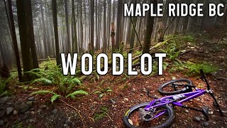
Service Road Atlas is a free to use, community-driven service for viewing and creating reports on the numerous back-country service roads around B.C. and Alberta.

map legend
Slope Aspect
Direction the slope faces
Flat N NE E SE S SW W NW
Trails Deemphasized
Trails are shown in grey.
disable
Only show trails with no bike usage.
Enable
Suggested Layers
Based on selected activity type

    Save the current map location and zoom level as your default home location whenever this page is loaded.
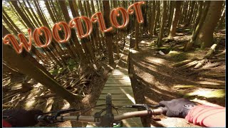
    Save
        Directions to shotgun trailhead (49.232730, -122.429900)

        Photos

        113 more »
        324 |
        Jul 13, 2016 @ 8:54pm
        Jul 13, 2016
        44 |
        Mar 16, 2023 @ 8:50pm
        Mar 16, 2023
        57 |
        Mar 16, 2023 @ 8:48pm
        Mar 16, 2023
        55 |
        Mar 16, 2023 @ 8:37pm
        Mar 16, 2023

        Videos

        25 more »
        youtuber SHOTGUN | Blue trail | Woodlot
        2:27 | 152 | Oct 21, 2024 , Maple Ridge
        EXPLORING WOODLOT BLUE TRAILS | WOODLOT, MAPLE...
        11:41 | 55 | Nov 14, 2025 , Maple Ridge
        Just Blast Your Way Out | Shotgun - Woodlot
        2:43 | 170 | May 6, 2024 , Maple Ridge
        youtuber Foggy lap at the Woodlot
        7:59 | 132 | Jan 7, 2024 , Maple Ridge

        Technical Trail Features (TTF)

        Trail Lists

        Routes with this trail

        4 miles 1,061 ft 5
        Fraser Valley Woodlot Quickie Fraser Valley Relive Your Ride For other ride suggestions for this and other...
        7 miles 1,586 ft 6
        Fraser Valley Woodlot Classic Fraser Valley Relive Your Ride For other ride suggestions for this and other...
        12 miles 3,146 ft 17
        Fraser Valley Woodlot Epic Fraser Valley Relive Your Ride For other ride suggestions for this and other...

        Trail Events

        Trail Products

        5 Reviews & Comments


        We hope you've been enjoying Trailforks!

        Create a FREE account to view trail comments and much more.

        • By BCpovTF Pro & contributors
        • #105 - 8,777 views

        Frequently Asked Questions About Shotgun

        Where is Shotgun located?
        Shotgun is located in Woodlot, Maple Ridge, British Columbia, Canada. It is part of the Woodlot trail network. The trailhead is located at coordinates 49.23273, -122.4299.
        How hard is Shotgun?
        Shotgun is rated as Blue difficulty. The physical rating is Hard. The average grade is 9.5%. The climb difficulty is rated Black Diamond.
        What is the elevation gain for Shotgun?
        The trail has 238 ft of elevation descent. The elevation ranges from 718 ft to 955 ft.
        How long is Shotgun?
        Shotgun is 2,507 ft long. The trail type is singletrack.

        Hit the Trail

        Open in App

        Get this trail on your phone instantly.
        open trail in app

        Download Trail

        Save to wishlist, Garmin & download.
        save the trail

        Find Related Routes

        Find routes and users activities that include this trail.
        find routes for this trail

        You must enter a description before submitting.