more stats
2,034 ft
Distance
-217 ft
Descent
00:02:46
Avg time
-218 ft
Altitude change
1,075 ft
Altitude min
1,293 ft
Altitude max
1,293 ft
Altitude start
1,076 ft
Altitude end
-10.7%
Grade
-28.5%
Grade max
0.4%
Grade min
1,860 ft
Distance down
118 ft
Distance flat
00:02:46
Avg time

Sidewinder Details

  • Activities
    • Mountain Bike
  • Riding Area
  • Difficulty Rating
  • Local Popularity
    30 in Mountain Biking
  • Global Ranking
    #111654 in Mountain Biking
  • Trail Type
    Singletrack
  • Bike Type
    DH, AM, XC
  • Direction
    Downhill Only
    Popular Direction Shown
  • Physical Rating
    Hard
  • Trail Visibility
    Always easy to follow
  • Dogs Allowed
    Yes
  • eBike Allowed
    Yes up to Class 1
  • TTFs on Trail
    Berm, Bridge, Drop, Jump
  • Year Opened
    2021

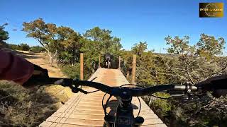
Sidewinder is a blue rated trail at Spider Mountain which contains flow, tech, a bridge over Tarantula, as well as 3 drops of various sizes to choose from. This trail is a fun way to warm up or session with friends, and was built by McGill Trail Fabrications and officially opened March 27th, 2021.

Trail Supporters

Bike Park

Recent Activity on Trail

Past Week
  • 2 rides
  • 15 miles average
6 Months
  • 79 rides
  • 19 miles avg distance
All
  • 490 rides
  • Last: Jun 21, 2026
c1c2c3c4
January
February
March
April
May
June
July
August
September
October
November
December
update trails status or condition

Sidewinder Trail Reports

Status:
on Mar 1, 2026
Avg: 3.99 (4 votes)
Your vote: 0

view (8,233)
close
3D
Trail Conditions
  • Unknown
  • Snow Groomed
  • Snow Packed
  • Snow Covered
  • Snow Cover Partial
  • Freeze/thaw Cycle
  • Icy
  • Prevalent Mud
  • Wet
  • Variable
  • Ideal
  • Dry
  • Very Dry
Trail Flow (Ridden Direction)
Trailforks scans users ridelogs to determine the most popular direction each trail is ridden. A good flowing trail network will have most trails flowing in a single direction according to their intension.
The colour categories are based on what percentage of riders are riding a trail in its intended direction.
  • > 96%
  • > 90%
  • > 80%
  • > 70%
  • > 50%
  • < 50%
  • bi-directional trail
  • no data
Trail Last Ridden
Trailforks scans ridelogs to determine the last time a trail was ridden.
  • < 2 days
  • < 1 week
  • < 2 weeks
  • < 1 month
  • < 6 months
  • > 6 months
Trail Ridden Direction
The intended direction a trail should be ridden.
  • Downhill Only
  • Downhill Primary
  • Both Directions
  • Uphill Primary
  • Uphill Only
  • One Direction
Contribute Details
Colors indicate trail is missing specified detail.
  • Description
  • Photos
  • Description & Photos
  • Videos
Trail Popularity ?
Trailforks scans ridelogs to determine which trails are ridden the most in the last 9 months. Trails are compared with nearby trails in the same city region with a possible 25 colour shades. Think of this as a heatmap, more rides = more kinetic energy = warmer colors.
  • most popular
  • popular
  • less popular
  • not popular
ATV/ORV/OHV Filter
Max Vehicle Width
inches
US Cell Coverage
Legend
cell carrier legend

Radar Time
Activity Recordings
Trailforks uses anonymized public activity data. ?
Activity Recordings
Trailforks uses anonymized public activity data. ?
Personal Heatmap
Activity Types
all / none
Options
2
Date range month
Winter Trails
Warning A routing network for winter maps does not exist. Selecting trails using the winter trails layer has been disabled.
Missing Trails
Most Popular
Least Popular
Trails are colored based on popularity. The more popular a trail is, the more red. Less popular trails trend towards green.
Jump Magnitude Heatmap
Heatmap of where riders jump on trails. Zoom in to see individual jumps, click circles to view jump details.
BC Backroad Status

Service Road Atlas is a free to use, community-driven service for viewing and creating reports on the numerous back-country service roads around B.C. and Alberta.

map legend
Slope Aspect
Direction the slope faces
Flat N NE E SE S SW W NW
Trails Deemphasized
Trails are shown in grey.
disable
Only show trails with no bike usage.
Enable
Suggested Layers
Based on selected activity type

    Save the current map location and zoom level as your default home location whenever this page is loaded.

    Save
        Directions to sidewinder-431817 trailhead (30.835820, -98.337150)

        Photos

        0 more »
        46 |
        Jun 22, 2025 @ 1:03pm
        Jun 22, 2025

        Videos

        5 more »
        FIRST TRIP DOWN SIDEWINDER - SPIDER MOUNTAIN, TX
        0:49 | 234 | Jan 2, 2024 , Burnet
        (Almost) EVERY TRAIL AT SPIDER MOUNTAIN
        14:58 | 170 | Dec 28, 2023 , Burnet
        Sidewinder | Full Trail Mountain Biking Spider...
        3:15 | 229 | Oct 15, 2023 , Burnet
        A Spider Mountain Bike Park Review - Sidewinder
        13:31 | 203 | Jul 10, 2023 , Burnet

        Reviews / Comments

        No reviews yet, be the first to write a review or ask a question.
        Use trail reports to comment on trail conditions.


        We hope you've been enjoying Trailforks!

        Create a FREE account to view trail comments and much more.

        • By cole-s & contributors
        • #431817 - 920 views

        Frequently Asked Questions About Sidewinder

        Where is Sidewinder located?
        Sidewinder is located in Spider Mountain Bike Park, Burnet, Texas, United States. It is part of the Spider Mountain Bike Park trail network. The trailhead is located at coordinates 30.83582, -98.33715.
        How hard is Sidewinder?
        Sidewinder is rated as Blue difficulty. The physical rating is Hard. The average grade is 10.7%.
        What is the elevation gain for Sidewinder?
        The trail has 217 ft of elevation descent. The elevation ranges from 1,075 ft to 1,293 ft.
        Is Sidewinder a point to point trail?
        Yes, Sidewinder is a point to point trail. The direction is Downhill Only. The trail type is singletrack.

        Hit the Trail

        Open in App

        Get this trail on your phone instantly.
        open trail in app

        Download Trail

        Save to wishlist, Garmin & download.
        save the trail

        Find Related Routes

        Find routes and users activities that include this trail.
        find routes for this trail

        You must enter a description before submitting.