This trail is permanently closed/decommissioned
more stats
823 ft
Distance
-72 ft
Descent
00:07:18
Avg time
-72 ft
Altitude change
1,934 ft
Altitude min
2,006 ft
Altitude max
2,006 ft
Altitude start
1,936 ft
Altitude end
-8.7%
Grade
-27.5%
Grade max
-1.7%
Grade min
823 ft
Distance down
00:07:18
Avg time

Sinker Details

  • Activities
    • Mountain Bike
  • Riding Area
    Eagle Rock
    Hyderabad
  • Difficulty Rating
  • Local Popularity
    5 in Mountain Biking
  • Trail Type
    Singletrack
  • Bike Type
    DH, AM
  • Direction
    Downhill Only
  • Physical Rating
    Moderate
  • Trail Visibility
    Sometimes hard to follow
  • Season
    Jan-Aug, Oct-Jan
  • eBike Allowed
    Yes up to Class 1
  • TTFs on Trail
    Berm, Drop, Jump, Gap Jump, Rock Garden, Skinny, Wallride
  • Year Opened
    2021

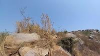
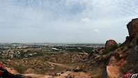
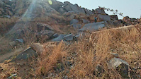
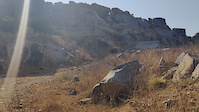
Sinker is a true gem of a trail, with the most elevation lost in a single trail in HYD. A trail comprising of primarily rollers and steep chutes from top to bottom with a really interesting starting spot

This trail is unsanctioned.

Disclaimer

Padding and Protection is Mandatory

Recent Activity on Trail

Past Week
  • 0 rides
  •  
6 Months
  • 0 rides
  •  
All
  • 2 rides
  • Last: Mar 19, 2022
update trails status or condition

Sinker Trail Reports

statusdatedescription
Apr 4, 2022 @ 2:00am
Apr 4, 2022
Trail System closed until further notice.
Mar 14, 2022 @ 3:18am
Mar 14, 2022
Feb 14, 2022 @ 12:09am
Feb 14, 2022
All Good! Some sections like the pro line rock roll have faced very minor erosion but the rest is fantastic!
May 5, 2021 @ 3:39am
May 5, 2021
Mar 16, 2021 @ 4:00am
Mar 16, 2021
more »
Status:
on Apr 4, 2022
Avg: 4.13 (1 votes)
Your vote: 0

view (11)
close
3D
Trail Conditions
  • Unknown
  • Snow Groomed
  • Snow Packed
  • Snow Covered
  • Snow Cover Partial
  • Freeze/thaw Cycle
  • Icy
  • Prevalent Mud
  • Wet
  • Variable
  • Ideal
  • Dry
  • Very Dry
Trail Flow (Ridden Direction)
Trailforks scans users ridelogs to determine the most popular direction each trail is ridden. A good flowing trail network will have most trails flowing in a single direction according to their intension.
The colour categories are based on what percentage of riders are riding a trail in its intended direction.
  • > 96%
  • > 90%
  • > 80%
  • > 70%
  • > 50%
  • < 50%
  • bi-directional trail
  • no data
Trail Last Ridden
Trailforks scans ridelogs to determine the last time a trail was ridden.
  • < 2 days
  • < 1 week
  • < 2 weeks
  • < 1 month
  • < 6 months
  • > 6 months
Trail Ridden Direction
The intended direction a trail should be ridden.
  • Downhill Only
  • Downhill Primary
  • Both Directions
  • Uphill Primary
  • Uphill Only
  • One Direction
Contribute Details
Colors indicate trail is missing specified detail.
  • Description
  • Photos
  • Description & Photos
  • Videos
Trail Popularity ?
Trailforks scans ridelogs to determine which trails are ridden the most in the last 9 months. Trails are compared with nearby trails in the same city region with a possible 25 colour shades. Think of this as a heatmap, more rides = more kinetic energy = warmer colors.
  • most popular
  • popular
  • less popular
  • not popular
ATV/ORV/OHV Filter
Max Vehicle Width
inches
US Cell Coverage
Legend
cell carrier legend

Radar Time
Activity Recordings
Trailforks uses anonymized public activity data. ?
Activity Recordings
Trailforks uses anonymized public activity data. ?
Personal Heatmap
Activity Types
all / none
Options
2
Date range month
Winter Trails
Warning A routing network for winter maps does not exist. Selecting trails using the winter trails layer has been disabled.
Missing Trails
Most Popular
Least Popular
Trails are colored based on popularity. The more popular a trail is, the more red. Less popular trails trend towards green.
Jump Magnitude Heatmap
Heatmap of where riders jump on trails. Zoom in to see individual jumps, click circles to view jump details.
BC Backroad Status

Service Road Atlas is a free to use, community-driven service for viewing and creating reports on the numerous back-country service roads around B.C. and Alberta.

map legend
Slope Aspect
Direction the slope faces
Flat N NE E SE S SW W NW
Trails Deemphasized
Trails are shown in grey.
disable
Only show trails with no bike usage.
Enable
Suggested Layers
Based on selected activity type

    Save the current map location and zoom level as your default home location whenever this page is loaded.

    Save
        Directions to sinker trailhead (17.296850, 78.512100)

        Photos

        21 more »
        128 |
        May 28, 2021 @ 2:07am
        May 28, 2021
        130 |
        May 28, 2021 @ 2:07am
        May 28, 2021
        113 |
        May 28, 2021 @ 2:07am
        May 28, 2021
        89 |
        May 28, 2021 @ 2:07am
        May 28, 2021

        Videos

        5 more »
        Finding the flow
        0:10 | 84 | Mar 9, 2022 , Hyderabad
        Stage 2 HRC X-duro
        0:00 | 96 | Jul 7, 2021 , Hyderabad
        Air Time
        0:13 | 99 | Apr 16, 2021 , Hyderabad
        Natural FLow
        0:11 | 57 | Apr 16, 2021 , Hyderabad

        Trail Events

        Reviews / Comments

        No reviews yet, be the first to write a review or ask a question.
        Use trail reports to comment on trail conditions.


        We hope you've been enjoying Trailforks!

        Create a FREE account to view trail comments and much more.

        • #415083 - 740 views

        Frequently Asked Questions About Sinker

        Where is Sinker located?
        Sinker is located in Eagle Rock, Hyderabad, India. It is part of the Eagle Rock trail network. The trailhead is located at coordinates 17.29685, 78.5121.
        How hard is Sinker?
        Sinker is rated as Black Diamond difficulty. The physical rating is Moderate. The average grade is 8.7%.
        What is the elevation gain for Sinker?
        The trail has 72 ft of elevation descent. The elevation ranges from 1,934 ft to 2,006 ft.
        Is Sinker a point to point trail?
        Yes, Sinker is a point to point trail. The direction is Downhill Only. The trail type is singletrack.

        Hit the Trail

        Open in App

        Get this trail on your phone instantly.
        open trail in app

        Download Trail

        Save to wishlist, Garmin & download.
        save the trail

        Find Related Routes

        Find routes and users activities that include this trail.
        find routes for this trail

        You must enter a description before submitting.